East India · State · WB
West Bengal
West Bengal rewards travelers who plan by landscape rather than trying to compress the state into one circuit. Kolkata is the practical gateway, a dense Hooghly-side city of institutions, sacred sites, markets and Bengali cultural life. North Bengal combines tea slopes, Himalayan towns, narrow-gauge rail heritage and weather-sensitive trekking. The south opens into tidal delta, island pilgrimage and the Bay of Bengal coast. Terracotta temple towns and Santiniketan add further cultural depth. The payoff is variety; the trade-off is distance and variable conditions. A Kolkata-and-heritage journey is manageable by rail and road, but Darjeeling, the Dooars and the Sundarbans deserve their own buffer. October to March is broadly comfortable for plains, coast and delta travel, although monsoon disruption and cyclone alerts can reshape plans. Build around connected regions, use current official or local guidance, and leave room for weather rather than treating any service or crossing as assured.
Regional notebook
Begin with the shape of the region.
West Bengal is several travel regions joined by Kolkata, not a uniform destination. It runs from Himalayan foothills and the Singalila ridge through the tea-and-forest Dooars, riverine plains and temple towns, to the Hooghly estuary, beaches and mangrove delta. It holds rail heritage, Bengal Renaissance institutions, pilgrimage, craft and wildlife landscapes. A northern hill journey is not a simple extension of a southern boat circuit.
Choose a hub and a question. Kolkata suits architecture and culture; Santiniketan and Bishnupur suit art and temple forms; Murshidabad and Malda trace political history. Darjeeling, Sandakphu, the Dooars and the Sundarbans each require time margins. This is a signature selection, not a complete inventory.
Landscape
Geography changes the journey.
The north rises sharply from Terai and Dooars into the eastern Himalaya, where heavy rain, landslides and road disruption are material risks. The Dooars are foothill grassland, tea country, streams and forest. Alluvial plains are shaped by the Ganges and distributaries; Bankura and Birbhum add lateritic ground, low hills and red-earth country.
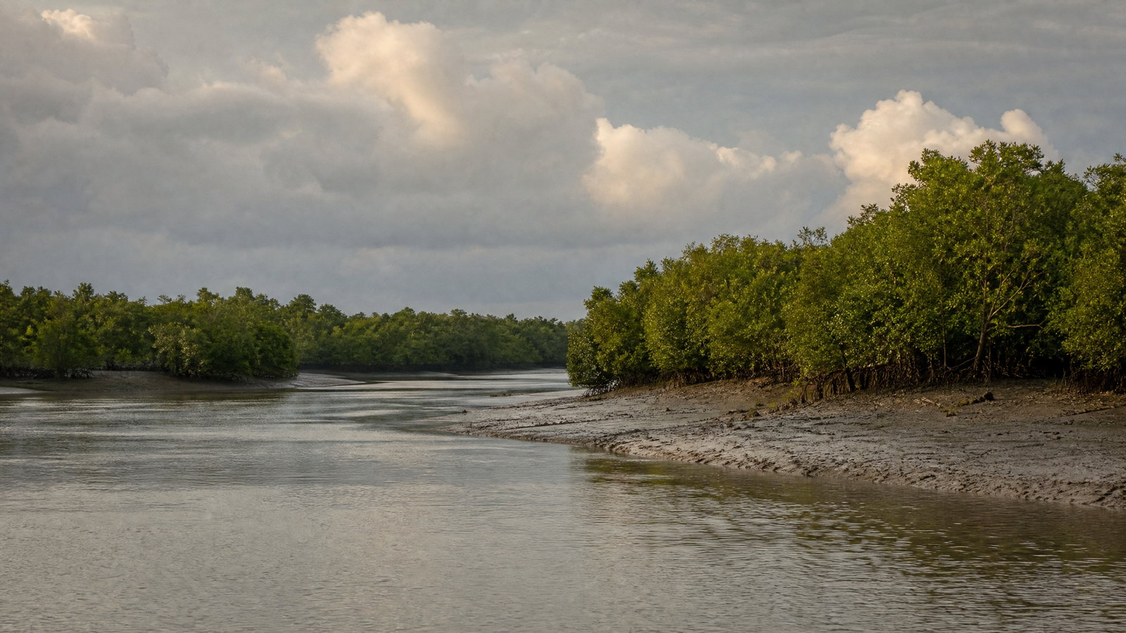
The southern edge is tidal. The Hooghly reaches the Bay of Bengal, while the Sundarbans is a shifting mangrove delta of creeks, mudflats and islands. Altitude, humidity and remoteness vary sharply. Plan by actual terrain, not straight-line distance.
Living culture
Arrive as a guest, not an audience.
Bengali language, literature, music, visual art and foodways shape much of public life, but West Bengal is not culturally uniform. Kolkata holds multi-faith histories. Santiniketan embodies Tagore’s internationalism; Bishnupur preserves Malla-era terracotta; Murshidabad and Malda retain Nawabi, Sultanate and trading layers. Nepali-speaking communities and Himalayan Buddhist traditions are central in the hills, while Adivasi communities and Santali traditions inform western and rural areas.
Festivals are meaningful civic and religious occasions, not a backdrop for intrusive photography. Ask before photographing people, rituals, artwork or workspaces, and remember that these are places of worship, study, livelihood and home.
Curated regional atlas
Places that reveal different parts of West Bengal
This is a selective, geographically varied starting point rather than an exhaustive list. Use it to choose a coherent route, not to compress every place into one trip.
metropolis and cultural capital · Kolkata district, lower Hooghly river corridor
Kolkata
Kolkata is the capital and most useful base for reading West Bengal’s modern history. On the Hooghly, it layers former imperial institutions with Bengali literary, artistic, religious and civic life. A thoughtful visit can join the Victoria Memorial and colonial civic fabric with museum collections, river ghats, book districts, neighbourhood markets and sacred architecture approached respectfully. The city’s value is its density of institutions and ordinary street life, including food, theatre, football and adda-like social exchange. It is also the principal gateway for rail, air and many onward road journeys.
Why this place matters
Choose Kolkata when you want an urban anchor rather than a scenic stop. It gives context for the Bengal Renaissance, anti-colonial politics, publishing, cinema and Durga Puja, while its transport network makes heritage extensions practical. The city suits travelers who enjoy walking and public transport but can be demanding in heat, humidity, traffic and crowding. Its multi-faith heritage is most rewarding when visited slowly and with attention to current worship or event schedules. Use at least two nights to absorb its scale, and more for museums, architecture or festival culture.
hill town, tea landscape and living railway heritage · Darjeeling district, eastern Himalayan foothills
Darjeeling Hills and Darjeeling Himalayan Railway
Darjeeling combines a busy Himalayan hill town, long-established tea country and a remarkable working railway. The Darjeeling Himalayan Railway links New Jalpaiguri and Darjeeling through steep terrain using narrow-gauge engineering, loops and reverses; its heritage significance rests partly on remaining a functioning line. Around town, viewpoints, monasteries, markets and tea slopes create a cultural landscape rather than a wilderness escape. Nepali-speaking communities and other long-settled groups are integral to the hills, so gardens and villages should be treated as workplaces and homes. Clouded mornings are normal, not a failed journey.
Why this place matters
Go for the interplay of mountain geography and human engineering. The railway makes the slope legible, while the town provides a base for views, local food and walks. It fits travelers accepting steep gradients, uneven pavements, crowds and weather variation better than those expecting a quiet resort. Darjeeling gives altitude without a multiday trek and contrasts well with Sandakphu. Keep expectations flexible: rain, maintenance, landslides and operating decisions can affect roads and rail services. Allow time margins for any onward connection rather than relying on a tight transfer.
high-altitude trekking landscape · Darjeeling district, Singalila range near the Nepal border
Sandakphu and Singalila Ridge
Sandakphu is West Bengal’s highest point and the signature high-ridge experience in the Singalila landscape. Routes rise through forest, bamboo, rhododendron country and exposed ridge sections toward Himalayan panoramas when weather permits. It is high-altitude terrain with thin air, cold wind and rapidly changing conditions. District guidance describes multiday approaches from the Manebhanjan side and strong seasonal contrast. Spring can bring flowering slopes; post-monsoon periods can improve visibility. The trek’s value is sustained walking through an ecologically sensitive mountain borderland, not chasing a single summit photograph.
Why this place matters
Choose Sandakphu if prepared for a real multiday mountain outing and an earned view of Kanchenjunga and distant ranges in clear weather. It offers more immersion than Darjeeling but demands more caution, gear and time. It is unsuitable for rushed itineraries, untested footwear, serious altitude sensitivity or fixed connections. A shorter hill stay may be wiser in unstable weather. Responsible trekking means keeping to permitted routes, pacing conservatively, using recognized support where needed and accepting that conditions may require a turnaround without a summit view.
foothill protected-area landscape · Alipurduar and Jalpaiguri districts, north Bengal
Dooars: Jaldapara and Gorumara
The Dooars is a humid foothill belt where rivers spill from the Himalaya through tea country, grassland and forest. Jaldapara’s grassland and riverine patches support West Bengal’s largest population of Indian one-horned rhinoceros, alongside elephants, birds and other fauna. Gorumara adds a compact protected landscape with forest-edge biodiversity and birdlife. Together they are a northern counterpoint to the high mountains: lower, warmer and ecologically different. Sightings depend on season, habitat, timing and luck; surrounding tea and forest villages are working landscapes, not open-access zones.
Why this place matters
Go to understand why Himalayan foothills matter beyond hill-station scenery. The Dooars offers riverine forest, grassland birds, elephant country and possible rhino observation through designated systems. It works well before or after Darjeeling, but is not a generic wildlife break. Heat, insects, rain and limited mobility on forest tracks are part of it. Travelers satisfied by habitat interpretation and quiet observation, even without headline species, will gain most. Keep expectations measured and let conservation priorities determine the experience, not a wish for proximity.
mangrove delta and protected wetland · South 24 Parganas district, lower Ganges delta
Sundarbans National Park and Tiger Reserve
The Sundarbans is a tidal mangrove world of creeks, estuarine mouths, mudflats and forested islands in the Ganges delta. The wider landscape spans India and Bangladesh and contains the world’s largest mangrove forest area; its Indian protected complex supports tiger, aquatic mammals, birds and reptiles. Tidal movement, salinity, erosion, sediment and monsoon water define it, not a conventional road-based national park. Visits unfold by regulated boat on approved channels. This is also a storm buffer and lived ecological frontier where conservation, fishing, forest dependence and climate exposure intersect.
Why this place matters
Go for ecological scale and the unusual experience of reading a forest from water. It suits birders, wetland-minded travelers and anyone interested in delta resilience, but not visitors demanding close wildlife encounters. Tiger viewing is uncertain; habitat and tidal quiet are the ethical reward. Boat time, humidity, limited step-free access and changing water conditions require patience. Leave enough time for weather and tide variation, and treat local communities as neighbours in a vulnerable delta rather than as part of an excursion display. Choose an authorized, conservation-respectful visit.
estuarine island and pilgrimage landscape · South 24 Parganas district, mouth of the Hooghly
Gangasagar Island
Gangasagar lies at the mouth of the Hooghly where river, sea and island life meet. It is a major Hindu pilgrimage setting, especially during the annual Mela, while outside peak periods its beaches and estuarine atmosphere offer a quieter delta view. Its meaning cannot be separated from the Kapil Muni shrine, ritual bathing, ferry-linked movement and the logistics of a low-lying coastal settlement. Visit it as a living sacred and environmental landscape, not an empty beach extension from Kolkata. Estuary weather, water level and crowd conditions shape every journey.
Why this place matters
Gangasagar suits travelers interested in pilgrimage geography and the transition from the Hooghly to the Bay of Bengal. It offers a different river lens from Kolkata and a less forested delta perspective than the Sundarbans. The intense pilgrimage period can be culturally powerful but demanding: crowds, temporary arrangements and transit pressure make it unsuitable for those seeking calm or easy access. Outside the gathering, focus on the coast and sacred setting with more space. In all seasons, factor in waterway dependency and avoid planning a critical connection immediately afterward.
World Heritage cultural landscape and university town · Bolpur, Birbhum district
Santiniketan
Santiniketan is a rural cultural landscape built around Rabindranath Tagore’s experiment in education, art and international humanism. Founded as a residential school in 1901 and expanded through Visva-Bharati from 1921, it joined open-air learning, landscape, craft, music and visual art. Its World Heritage value lies in a continuing ensemble of buildings, gardens, pavilions, artworks and educational traditions, including Ashram, Uttarayan and Kala Bhavana areas. It is not a static memorial: it remains part of a contemporary university environment, making respect for campus rhythms and conservation essential.
Why this place matters
Go when ideas, art and place matter as much as architectural photographs. Santiniketan reveals a Bengal that is rural, modernist and internationally connected, correcting a Kolkata-only view of the state. It pairs well with Birbhum craft exploration and is reachable from Kolkata, though a day visit can feel thin. Choose two nights for galleries, local craft context and the landscape. Festival periods can be vivid, but access and crowding are variable. Approach it as an active place of learning, not an open-air museum or an assumed event venue.
historic temple town and craft landscape · Bankura district
Bishnupur
Bishnupur is West Bengal’s clearest introduction to brick-and-terracotta architecture associated with the Malla rulers. Its clustered temples translate curved Bengali hut forms, ratna towers and narrative panels into fired clay, creating a visual language unlike stone temple complexes. Nationally protected monuments include Rasmancha, Jor-Bangla, Shyam Rai, Madanmohan, Lalji and others. The town’s wider identity includes music and craft traditions. Its dry, red-earth Bankura setting matters: this is a western Bengal heritage landscape, not an isolated monument collection. Slow looking rewards more than entering every shrine.
Why this place matters
Choose Bishnupur for architectural detail and a link between monumental heritage and living craft practice. It is a strong alternative to big-city sightseeing for travelers who enjoy close observation of brickwork, iconography and form. Combine it with Kolkata or Santiniketan, but allow time for cooler light and for understanding terracotta as a local medium. It is less suitable for travelers seeking dramatic nature. Some temples remain religious places, so fragile panels must never become props for climbing, touching or casual damage. A measured visit protects both material and meaning.
former Nawabi capital and riverine heritage town · Murshidabad district, Bhagirathi river corridor
Murshidabad
Murshidabad preserves the scale and complexity of a former political centre of Bengal. Along the Bhagirathi corridor, palaces, mosques, cemeteries, imambara spaces, river views and bazaars reflect the Nawabi period and later colonial entanglements. Hazarduari Palace, the Nizamat Imambara and nearby memorial landscapes are visible anchors, but the town is best read as a layered river city rather than a palace stop. Silk and handicraft traditions connect heritage to current livelihoods. Its material record holds power, trade, conflict and changing patronage beyond any single famous battle or ruler.
Why this place matters
Go for a deeper encounter with Bengal’s eighteenth- and nineteenth-century political history than Kolkata alone provides. Murshidabad rewards interest in courtly architecture, Islamic built heritage, river geography and the transition from regional power to colonial rule. An overnight stay helps slow the pace between distinct precincts. Conditions are warm for much of the year, and buildings can involve steps, open grounds and limited shade. Treat museum, palace and sacred-site protocols separately rather than assuming one access rule across town. Modest dress and attentive conduct are particularly important at active religious sites.
medieval urban archaeology and historic region · Malda district, north-central West Bengal
Malda, Gaur and Pandua
Malda is the base for the dispersed historic landscapes of Gaur and Pandua, where Bengal Sultanate architecture, archaeological remains and later urban history spread across a broad plain. Mosques, gateways, tombs, tanks and ruined fabric are fragments of once major political and trading centres rather than one compact complex. The district is also known for mango cultivation, giving the circuit seasonal agricultural context. It is a place for travelers ready to connect sites by road and imagine urban scale through surviving structures and open ground. Heat, dust and distance can outweigh polished interpretation.
Why this place matters
Go beyond colonial and Nawabi narratives toward medieval Bengal’s Islamic architecture and urban networks. Gaur and Pandua reward history and architecture-minded visitors willing to accept a scattered archaeological experience. Pair Malda with Murshidabad on a northward heritage route, not a rushed day trip from Kolkata. It is less suited to travelers seeking continuous museum display or pedestrian infrastructure. Bring sun protection, water and patience for transfers, and let the open land between monuments remain part of the story. Respect all protected boundaries and refrain from climbing on fragile structures.
former princely town and palace precinct · Cooch Behar district, north Bengal plains
Cooch Behar
Cooch Behar offers a northern-plains counterpoint to Darjeeling and the Dooars. The former princely town is known for the Cooch Behar Rajbari, broad civic layout and religious landmarks including the Madan Mohan Temple. Its heritage reflects a distinct regional courtly history shaped by a borderland setting and eastern South Asian connections. It works as an architectural and historical pause in a north Bengal itinerary, especially for travelers who prefer a lived urban centre to another hill station. Its lowland streets are easier than Darjeeling’s slopes, though summer heat remains tiring.
Why this place matters
Choose Cooch Behar to broaden a north Bengal trip beyond tea, mountains and wildlife. The Rajbari gives a visual entry to princely-state history, while temples and markets show an active regional centre rather than a sealed historic enclosure. Pair it with the Dooars or approach it as a separate rail-and-road circuit. One night usually supports a focused heritage visit; history-minded travelers can linger. The experience works best as context for northern plains and borderland culture, not as a copy of Kolkata’s colonial core. Plan outdoor walking for cooler morning or late-afternoon light.
Bay of Bengal beach corridor · Purba Medinipur district
Digha and Tajpur Coast
Digha and nearby Tajpur show a different Bay of Bengal edge from the Sundarbans: open beaches, fishing-linked settlements, resort-town activity and shorebird and crab habitat. Digha is a long-established coastal town with a built-up promenade and busy beach culture; Tajpur has a less urban feel, red crabs and aquaculture surroundings. The appeal is not untouched wilderness. This is a working, changing shore where recreation, coastal engineering, fisheries and weather exposure meet. Visit with realistic expectations about crowds, tides, erosion and sea conditions rather than a perfect swimming beach.
Why this place matters
Go for an accessible coastal break from Kolkata or a contrast to inland heritage circuits. Digha suits travelers wanting services and activity; Tajpur better fits a quieter shoreline walk and observation of coastal texture. Neither is a guaranteed swimming destination: surf, currents, storms and local safety directions matter more than an itinerary. Make the visit responsible by giving crabs and birds space, avoiding litter and sand driving, and recognizing the livelihood importance of fishing and aquaculture. Coastal conditions can change rapidly, so let safety guidance take precedence over plans.
Season and pace
Choose a date window for the experience, then keep a fallback.
October through March is usually most comfortable for Kolkata, heritage towns, coast and delta. Winter can be foggy on the plains and cold at elevation. Spring brings rhododendrons to high hills; post-monsoon weather can improve ridge visibility. Sandakphu can be cold, windy and snowy.
Late March through June is often hot and humid in the plains and coastal belt. The June–September monsoon can interrupt hill roads and railway operations and waterlog low-lying cities. Coastal areas face severe weather. Month labels are broad guidance: consult short-term forecasts, district advisories, river and sea conditions, and site notices before travel.
Movement and planning
Distance on a map is not the same as usable travel time.
Moving through the region
Kolkata is the main arrival and transfer hub, with air, major rail terminals, metro, suburban rail, buses, ferries and taxis. Rail and road connect it with major heritage towns and Digha, though timing varies. Northern itineraries normally use the Siliguri–New Jalpaiguri gateway; allow a full day for hill transfers.
The Darjeeling Himalayan Railway is living heritage, not a timing-proof attraction: weather and maintenance can affect running. Sundarbans and Gangasagar journeys rely on changing waterways. Step-free access, even surfacing and accessible toilets are uneven at historic, hill, boat and rural sites. Confirm current accessibility with the relevant local or official channel before committing.
Building a workable route
Pair places that share a corridor. Santiniketan and Bishnupur form a culture circuit; Murshidabad and Malda emphasize history. Darjeeling, Sandakphu and the Dooars form a northern nature circuit. Gangasagar, Digha and the Sundarbans are separate southern propositions that should not be rushed together.
Carry layers and rain protection in hills, sun protection in the plains and appropriate insect precautions in wetland settings. For high-altitude trekking, pace conservatively and allow a turnaround. For waterways, verify warnings on the day. Festival dates, protected-area entry, train running and ferry timings change; confirm details close to departure and keep an overnight buffer before important onward travel.
Travel responsibly
The regional context includes its limits.
West Bengal’s places include vulnerable precincts, working landscapes, tidal islands and wildlife habitat. Respect resident control: do not enter private gardens, fields, workspaces or worship areas without permission. Keep waste from drains and waterways, and ask before photographing people or work.
In protected areas, wildlife welfare outranks proximity. Remain with authorized guides, vehicles or boats; stay on permitted routes; keep noise low; and never feed animals. Do not pursue a tiger, rhinoceros or dolphin encounter. On the coast, follow safety flags and local restrictions, avoid driving on sand, and give shorebird and crab habitat space. Respect temporary closures as safety and stewardship measures.
This is an evergreen regional guide. Weather, permits, closures, transport and local rules can change; confirm material conditions through the relevant local or official channel before travel.