Northeast India · State · TR
Tripura
Tripura is a compact, green northeastern state where royal-era Agartala, carved sacred hills, lake palaces, forest sanctuaries and highland villages can be combined without attempting a rushed circuit. Its strongest contrast is between the Bengali-speaking urban and temple belt in the west and south, the forested interior and lakes of the east, and the Mizo-influenced Jampui uplands in the north. Unakoti and Chabimura reward visitors who want archaeology embedded in living landscapes; Neermahal and Ujjayanta Palace give a legible Manikya-era frame; and sanctuaries shift the emphasis to habitat, not guaranteed sightings. Roads link the principal centres, but rain, distance and limited local transport make a flexible itinerary more useful than a dense checklist. Plan around cool, clearer months, retain spare time for weather, and approach pilgrimage, community life and wildlife as places with their own rhythms rather than staged attractions.
Regional notebook
Begin with the shape of the region.
Tripura rewards a layered journey, not a rushed landmark circuit. Agartala supplies the clearest base for royal history, museums and onward links. Central and southern lowlands hold Udaipur’s temple landscape, Melaghar’s lake palace, Pilak’s archaeology and Chabimura’s wooded river gorge. Eastward lie Dumboor’s reservoir and the Gumti landscape; northbound are Unakoti’s reliefs and Jampui’s Mizo-influenced uplands.
There is no coastal itinerary: lake islands, riverbanks, low hills and valleys create the geographic contrast. Visitors who prefer urban heritage can focus on Agartala and Melaghar; archaeology-minded travellers should slow down at Unakoti, Pilak and Chabimura; sanctuary visits are about habitat, not assured animal sightings. Six to eight days permits real contrast and weather flexibility.
Landscape
Geography changes the journey.
Tripura is nearly surrounded by Bangladesh, with a narrower eastern and northern connection to the rest of India. Its terrain is a mosaic of north–south low hills, valleys, cultivated plains, forest patches, streams and the Gomati river system. Agartala and the west feel lowland, while the northeast rises to Jampui Hills, around 930 metres at its highest ridge. Jampui can be cooler and mistier than Udaipur, Melaghar and Agartala.
Water shapes its signature landscapes: Rudrasagar is an internationally recognized wetland, Dumboor a reservoir of islands and confluences, and the Gomati links Udaipur, Amarpur and Chabimura. Monsoon rain can swell rivers, disrupt roads and make slopes or rock surfaces hazardous. Use daylight for rural travel and treat timings as estimates.
Living culture
Arrive as a guest, not an audience.
Tripura is shaped by Bengali-speaking communities, Indigenous peoples, courtly rule, migration, agriculture and borderland exchange. Bengali and Kokborok are central to cultural orientation; English appears in administration and many visitor settings. The Manikya legacy is visible at Ujjayanta Palace and Neermahal, while Khumulwng introduces tribal material culture, weaving, dress, instruments and shifting-cultivation knowledge.
Tripura Sundari is an active pilgrimage setting; Unakoti combines monumental Shaiva imagery with annual worship; Pilak preserves Hindu and Buddhist visual traditions; and Chabimura’s reliefs retain local meaning. Dress modestly, ask before photographing people or ritual activity, and do not reduce communities or practice to display. Fairs can be rewarding but alter crowd levels and movement.
Curated regional atlas
Places that reveal different parts of Tripura
This is a selective, geographically varied starting point rather than an exhaustive list. Use it to choose a coherent route, not to compress every place into one trip.
royal palace and state museum · Agartala, West Tripura
Ujjayanta Palace and Tripura State Museum
Ujjayanta Palace is the former Manikya royal palace at the heart of Agartala and now houses the Tripura State Museum. Its symmetrical white façade, domes, formal water features and landscaped compound make it the clearest introduction to the capital’s courtly past. The museum context is especially useful before travelling onward: it connects royal history with archaeology, ethnography, painting, craft and the cultural histories of Tripura’s communities. The setting is urban and generally easier to reach than the state’s hill or forest sites, making it a practical first or final stop rather than a substitute for them. Allow time for both the building and the galleries, whose operating arrangements can change.
Why this place matters
Go here to frame the Manikya legacy before travelling farther. The palace distinguishes royal history from older sacred landscapes, while the museum prepares visitors for Khumulwng and Jampui. It is the best option for a substantial cultural visit with limited time and offers an easy place to begin or end a route. The trade-off is an urban institutional experience, not a village or wilderness encounter; pair it with a wetland, temple or hill stop for a more complete sense of the state.
water palace and wetland · Melaghar, Sepahijala District
Neermahal and Rudrasagar Lake
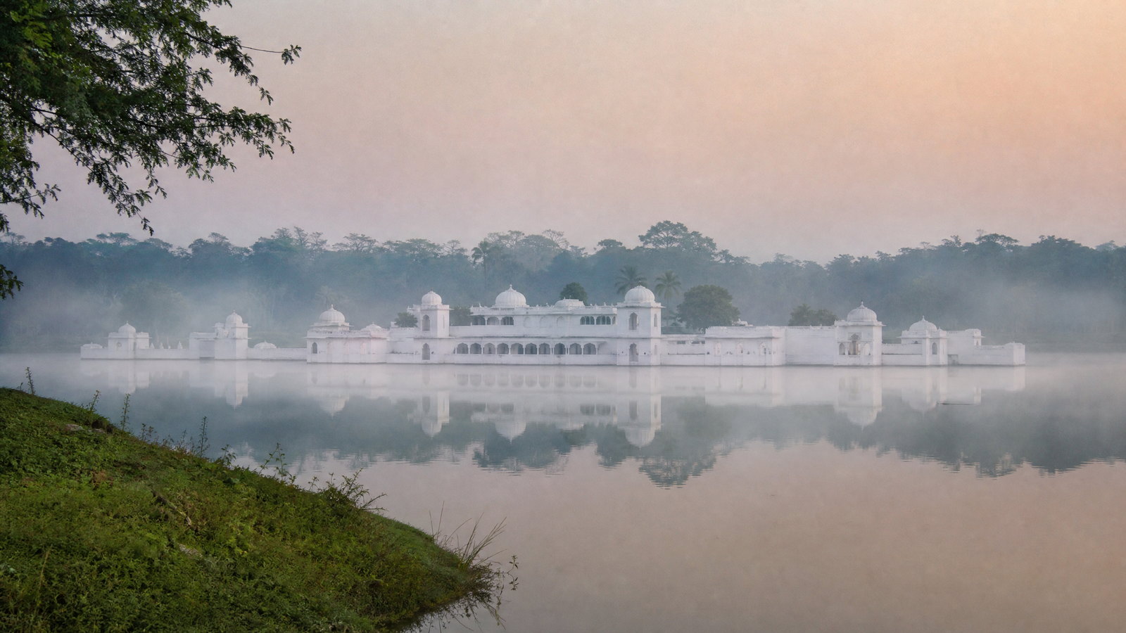
Neermahal is a former summer palace built for Maharaja Bir Bikram Kishore Manikya in the middle of Rudrasagar Lake, near Melaghar. Completed in 1938, the palace combines Hindu and Muslim architectural vocabularies and separates a more private royal side from an open-air performance area. Its identity cannot be separated from the lake: Rudrasagar is a wetland of international importance, and the water crossing, reflections and surrounding lowland vegetation are integral to the visit. This is one of Tripura’s most photogenic built landscapes, but water level, weather and boat operation shape the experience more than a conventional roadside monument would.
Why this place matters
Go for the unusual union of royal architecture and wetland. Neermahal is a more atmospheric counterpart to Ujjayanta: one is urban, the other reached across a lake. It also foregrounds the environmental care behind water heritage. It is an efficient Agartala excursion, but peak weekends and festivals may be busy, and rain or water conditions can alter the crossing. Allow time to study the palace’s relationship to Rudrasagar rather than making it only a photo stop. This also avoids treating a sensitive lake as scenery alone.
sacred archaeological landscape · Unakoti Range, near Kailashahar, Unakoti District
Unakoti Rock-cut Sculptures and Reliefs
Unakoti is a forested hill landscape of colossal and smaller rock-cut Hindu reliefs, loose sculptures, streams and sacred pools near Kailashahar. The major panels include monumental Shaiva imagery and Ganesha figures, with stylistic evidence associated with early medieval worship; local traditions and the annual Ashokashtomi gathering keep the place culturally active. The site is on India’s tentative heritage list, which signals recognition but is not the same as formal World Heritage inscription. Its power comes from scale and setting: carvings emerge from steep rock among rain-fed vegetation rather than from a contained museum or temple courtyard. Erosion, wet surfaces and changing paths are part of its material reality.
Why this place matters
Go because art, geology, forest and worship are inseparable here. Unakoti rewards slow looking and attention to local inflections of familiar Hindu imagery. It contrasts with Chabimura’s later river setting and makes an exceptional archaeological anchor for the north. Do not rush it as a same-day dash from Agartala: travel, stairs and rain deserve time. During the annual fair, crowds and devotion transform the visit, which may appeal to pilgrims but reduce the sense of quiet study. Allow a full morning for its many panels.
Hindu pilgrimage temple · Udaipur, Gomati District
Tripura Sundari Temple
Tripura Sundari Temple, widely known as Matabari or Tripureswari, is an active Hindu pilgrimage centre in Udaipur, the old royal capital area. Set on a low hill above the temple precinct, it is one of the state’s most important devotional sites and anchors a broader landscape of ponds, shrines and historical associations around Udaipur. The strength of a visit lies in observing the rhythm of a functioning place of worship rather than treating it solely as historic architecture. Festival periods can bring a particularly charged atmosphere, but they also mean queues, altered movement and limits on quiet viewing. The surrounding town is a useful southern base for heritage exploration.
Why this place matters
Go to understand living religious practice and Udaipur’s historic importance. Matabari differs from Unakoti and Pilak because current devotion and ritual protocol define the experience. Combine it with Udaipur’s temple landscape or a transfer toward Amarpur for a balanced southern day. Visitors seeking quiet should choose an early, non-festival visit; visitors curious about pilgrimage can allow more time. In either case, follow site direction for dress, footwear, queues and photography rather than relying on assumptions from elsewhere. This protects worshippers as well as your own visit.
riverine rock-relief landscape · Near Amarpur, Gomati District
Chabimura (Devtamura) Rock Reliefs
Chabimura, also called Devtamura, places large Hindu rock reliefs on steep faces above the Gomati River corridor near Amarpur. The panels include Shiva, Vishnu, Kartika and a monumental Mahishasuramardini, generally dated to the fifteenth and sixteenth centuries. Forested slopes, a river approach and the visual shock of carvings rising from rock make this a landscape experience as much as an archaeological one. It differs from Unakoti in period, geography and scale of encounter: here, carved figures are dispersed along a gorge-like river setting and some rock surfaces have been affected by erosion and slope movement. The location makes weather assessment essential, especially in wet months.
Why this place matters
Go for a dramatic fusion of river scenery and monumental relief sculpture. It suits visitors who want sacred imagery embedded in a difficult natural canvas and who accept a more rural outing. Pair it with Udaipur or Amarpur, but do not make a monsoon-day promise: rain, wet ground and river conditions affect safety. The remote setting brings fewer conveniences, while the cliff setting rewards patient observation. Visit with a flexible schedule and never trespass on carvings, unstable slopes or protected river edges.
reservoir lake and island landscape · Gandacherra Subdivision, Dhalai District
Dumboor Lake and Tirthamukh
Dumboor Lake is a large reservoir landscape in the Gandacherra area, formed around the Raima and Sarma river confluence and associated with the Gomati hydel project. Its drum-shaped name, lush shorelines, many islands and winter birdlife give it a scale unlike Rudrasagar’s palace wetland. Tirthamukh, near the project and the Gomati’s origin point, is a religious gathering place associated with the Pous Sankranti fair in January. The lake’s appeal is spaciousness: water, wooded hillocks, island views and a slower eastern Tripura atmosphere. It is a long overland journey from Agartala, so it needs a flexible plan and should not be judged by whether every water activity is operating.
Why this place matters
Go for eastern Tripura’s largest water-and-hill panorama and to see infrastructure, rivers and faith converge. Dumboor contrasts with compact, royal Neermahal: it is rural, expansive and less easily compressed into a short visit. Winter can bring gentler conditions; January adds cultural activity but less quiet. It suits travellers who accept a long journey and prefer landscape over urban amenity. Keep boating optional, build in an overnight or buffer, and make decisions according to local weather and water-safety advice. A slower itinerary is the more rewarding choice.
highland village and mountain landscape · Vanghmun, North Tripura District
Jampui Hills and Vanghmun
Jampui Hills is Tripura’s highest hill range, rising to roughly 930 metres and centred on villages such as Vanghmun. The uplands are known for layered ridge views, dense green cover, seasonal mist, orchards and a cultural landscape with Mizo influence. Betlingchhip is the best-known high point, but the value of Jampui lies as much in the road journey, changing climate and village pace as in one summit view. Compared with Tripura’s warmer plains, this is a cooler and more textured environment, though clouds may obscure panoramas. It is not an alpine destination: trails, accommodation and viewpoints should be approached with low-impact expectations and current local guidance.
Why this place matters
Go for Tripura’s strongest elevation and cultural contrast. Jampui rewards mist, village-scale exploration and a slower hill rhythm after the capital or southern circuit. Distance is the trade-off, and views are never assured even in the broadly drier season. It suits travellers who value landscape and local context more than a fixed attraction list. Spend enough time to adjust to weather and changing light, seek local orientation, and respect private farms, orchards and community spaces rather than wandering by assumption.
wildlife sanctuary and nature learning landscape · Bishalgarh Subdivision, Sepahijala District
Sepahijala Wildlife Sanctuary
Sepahijala Wildlife Sanctuary is a managed forest and visitor-learning landscape about 25 kilometres from central Agartala. Notified in 1987, it combines sanctuary habitat with a zoological park, botanical garden, trails, interpretation facilities and water-edge recreation areas. The sanctuary is associated with species such as hoolock gibbon, spectacled langur and leopard cat, though a responsible visit treats sightings as uncertain rather than promised. Its accessibility from the capital makes it useful for families, students and travellers who have limited time for more remote forest areas. The mix of managed facilities and wildlife habitat also makes clear why quiet behaviour and adherence to designated areas matter.
Why this place matters
Go for the most practical introduction to Tripura forest biodiversity, particularly from Agartala. Sepahijala is easier to reach than Trishna or Gumti and works well for a limited-time itinerary. The trade-off is a managed setting with zoological and learning facilities, not remote wilderness. It pairs well with Ujjayanta and Neermahal by adding an ecological dimension to royal and wetland heritage. Choose it for interpretation, birds and a quiet nature walk, not assured wildlife sightings or close animal encounters. This is especially valuable for first-time visitors.
wildlife sanctuary and grassland-forest mosaic · Near Belonia, South Tripura District
Trishna Wildlife Sanctuary
Trishna Wildlife Sanctuary near Belonia is a southern Tripura protected landscape notified in 1988. Its visitor experience is built around forest, water bodies, watchtower views, a butterfly area and designated nature trails; official material also identifies hoolock gibbon, spectacled langur and leopard cat among notable fauna. The wider conservation landscape is associated with gaur, often called Indian bison, but wildlife movement is never a schedule. The sanctuary is substantially farther from Agartala than Sepahijala and therefore works best when integrated with a southern itinerary rather than as an impulsive capital day trip. Winter water bodies can add bird interest, while rain changes trail and road conditions.
Why this place matters
Go for a spacious southern forest experience where water, woodland and open views matter as much as animals. Trishna complements Pilak or Udaipur and suits travellers who prefer conservation landscapes to museums. The trade-off is travel time: a flexible half or full day is deserved, especially when roads or weather are uncertain. Bring binoculars, but expect habitat rather than certainty of wildlife sightings. Its best value is careful observation of a managed forest mosaic, not pressure to find gaur or other animals.
archaeological landscape · Jolaibari area, South Tripura District
Pilak Archaeological Landscape
Pilak is a dispersed archaeological landscape in southern Tripura where excavations have revealed Hindu and Buddhist images, terracotta plaques and related remains across an agricultural setting. The material is generally dated to the eighth and ninth centuries, and prominent finds include large figures identified as Avalokiteshvara and Narasimha. Rather than a single monumental complex, Pilak asks visitors to think about the survival and rediscovery of sculptural traditions across a broad rural area. It is also recognized among Tripura’s centrally protected archaeological locations. The annual local archaeology and tourism gathering can highlight cultural programming, but the setting remains primarily a heritage landscape, not a theme park.
Why this place matters
Go to encounter a rich record of religious exchange in a landscape rather than a single monument. Pilak complements Unakoti with Hindu and Buddhist traditions in a lowland agricultural setting, and it pairs well with Trishna in a southern route. The scattered remains reward archaeology-minded visitors more than those expecting immediate spectacle. Allow time to understand the setting and its conservation needs; respect barriers, local farming, interpretation limits and the possibility that individual features may be inaccessible during ongoing management work.
cultural landscape and heritage centre · Khumulwng, West Tripura
Khumulwng Eco Park and Heritage Centre
Khumulwng Eco Park lies at the headquarters area of the Tripura Tribal Areas Autonomous District Council, about 22 kilometres from Agartala. Its park setting includes the Tribal Museum and Heritage Centre, which presents models of the state’s tribal communities, traditional clothing, tools, musical instruments, weaving and stages of jhum cultivation alongside a narrative of Tripura’s political transition. This is a curated, educational setting rather than a substitute for direct community life. Its strength is orientation: visitors can learn vocabulary and visual context that enrich later travel to hill villages, craft areas and rural landscapes. The park’s proximity makes it an achievable half-day cultural excursion from the capital.
Why this place matters
Go to look beyond royal and Hindu sites. Khumulwng introduces Indigenous cultures through objects, dress, instruments and livelihood histories before remote travel. Paired with Ujjayanta, it reveals differing institutional narratives of Tripura’s past and present. The park is also a convenient short excursion from the capital. Displays are necessarily selective and cannot represent whole communities; approach the centre as an informed starting point, not a template for everyday village life. Carry that humility into later visits to rural and hill areas.
compact wildlife sanctuary · Near Panisagar, North Tripura District
Rowa Wildlife Sanctuary
Rowa Wildlife Sanctuary is a small, forested protected area near Panisagar in North Tripura. Its compact scale and canopy-rich setting make it a complementary nature stop on a northern route rather than a replacement for larger forest landscapes such as Trishna or Gumti. Official district tourism material emphasizes its flora and fauna, including primates, birds and reptiles, and presents it as a quieter place for nature walks and bird observation. Its location can make it a useful break between the capital region, Unakoti and Jampui country, though exact trail use and visitor facilities should not be assumed. As with every sanctuary, habitat observation matters more than a tally of animals seen.
Why this place matters
Go if already travelling north and wanting a quiet forest pause alongside Unakoti or Jampui. Its small scale sharpens attention to birds, canopy, leaf litter and woodland detail. Limited infrastructure and few animal sightings are possible; habitat observation is the point. Include it only if access is confirmed and the northbound route has enough weather and road flexibility. It is most rewarding for visitors prepared to slow down, stay quiet and recognize that a protected forest is not a place for guaranteed encounters or off-trail exploration.
Season and pace
Choose a date window for the experience, then keep a fallback.
Humidity, heat and heavy rain determine the practical calendar. November–February is usually clearest and most comfortable for walking, lakes and sanctuary visits. Winter mornings can be cool and misty in Jampui, so pack a layer. March and April are hotter and can coincide with religious observances, bringing both cultural intensity and crowds.
June–September monsoon rain can be intense and locally variable. Meteorological reporting documents waterlogging, road disruption and impacts on access to Jampui, Unakoti and other sites. October is a transition, not a dry-weather guarantee. Confirm forecasts, water conditions, opening hours and advisories close to departure; do not make boat or forest days inflexible connections.
Movement and planning
Distance on a map is not the same as usable travel time.
Moving through the region
Maharaja Bir Bikram Airport serves Agartala, the state’s primary air gateway. Rail and road connections make the capital the practical arrival base. Neermahal and Sepahijala suit a capital-based outing; Udaipur, Pilak, Amarpur and Chabimura make a southern loop. Unakoti and Jampui need a northbound allocation, while Dumboor and Gumti country merit an overnight or deliberately paced eastern excursion.
Shared transport can serve towns but is less dependable for scattered sites, forest gates and lake edges. A local driver may add flexibility but cannot override closures. Unakoti and Chabimura can involve stairs, uneven ground, mud or wet stone; Neermahal involves a water crossing. Confirm step-free options, toilets, seating and safe boarding for individual access needs.
Building a workable route
Choose the Tripura you want to understand. For six days, base first in Agartala for Ujjayanta and Khumulwng, add Sepahijala or Neermahal, then Udaipur and Tripura Sundari; choose either Unakoti–Jampui or Amarpur–Chabimura–Dumboor. An eight-day route can include both with flexible overnights away from Agartala. This prevents constant backtracking.
Carry rain protection, water, sun cover, grip footwear and a dry bag. Start early for outdoor reliefs, lake light and cooler walks. Confirm current hours, entry procedures, boat operation, photography, roads and identification requirements through the relevant local or official channel before travel. Retain a contingency day for hill, river, lake or sanctuary terrain.
Travel responsibly
The regional context includes its limits.
Tripura’s reliefs weather under intense rain, its lakes depend on wetland health, and its sanctuaries are managed habitats. Stay on marked paths; never climb carvings, feed animals or use loud audio. Keep distance from primates and birds. On water, follow crew instructions, use provided safety equipment and accept cancellations when weather changes.
At temples and fairs, follow queues, footwear and photography directions. Buy crafts transparently and avoid treating cultural objects as props. Carry out all litter and reduce disposable plastic. Never explore restricted or sensitive areas on assumption: confirm current access locally, follow site and forest staff, and plan travel to leave fragile places and communities with less disturbance.
This is an evergreen regional guide. Weather, permits, closures, transport and local rules can change; confirm material conditions through the relevant local or official channel before travel.