West India · State · RJ
Rajasthan
Rajasthan is India’s largest state by area, a vast west-northwestern landscape where the Thar Desert, the ancient Aravalli hills, dry plains, lakes, forests and river valleys create markedly different journeys. Jaipur, the capital, is a logical urban gateway, but the state rewards unhurried regional choices: desert architecture and living fort streets around Jaisalmer; Marwar’s blue-washed Jodhpur; the lake-and-hill setting of Udaipur; Mewar’s monumental forts; and eastern wetlands and tiger forest. Its heritage is not a single royal tableau. Forts contain temples, markets, water systems and, in some cases, continuing homes; craft, music, faith and everyday commerce remain part of the setting. October to March is generally most comfortable, while the hot season can severely limit daytime walking and the monsoon transforms the southeast more than the dry northwest. Distances are substantial, terrain is uneven at many historic sites, and wildlife access is managed rather than spontaneous. Build an itinerary around two or three connected regions, leave room for rest and local timing, and approach sacred, inhabited and protected places with patience.
Regional notebook
Begin with the shape of the region.
Rajasthan is best approached as several travel regions, not one circuit. Jaipur concentrates planned urban form and nearby Amber; Jodhpur and Jaisalmer foreground Marwar, sandstone and the Thar; Udaipur, Kumbhalgarh and Mount Abu bring hills, lakes and forest edges; Bharatpur and Sawai Madhopur add wetland and dry forest. This curated selection is an orientation, not an exhaustive list.
Choose depth over mileage. Pair Jaipur with Shekhawati or Ranthambore; Jodhpur with Jaisalmer; or Udaipur with Kumbhalgarh, Chittorgarh and Mount Abu. Major cities have the widest transport and medical options, while desert edges, small towns and protected areas need more time and a current local check.
Landscape
Geography changes the journey.
Rajasthan covers 342,239 square kilometres in India’s northwest. The Thar shapes the west, but dunes, rocky ground, thorn vegetation, villages and old trade settlements make it a lived, varied desert. The Aravalli range broadly divides the drier northwest from relatively better-watered east and southeast. South Rajasthan has lake basins and forest mosaics; Bharatpur is wetland country; the southeast combines dry woodland, lakes and escarpments.
Terrain changes effort. Desert drives are long, forts demand ramps and steps, and Mount Abu is a genuine upland break. Rain can alter low crossings and park conditions; carry water, seek shade and plan conservatively.
Living culture
Arrive as a guest, not an audience.
Forts and palaces are only one layer of Rajasthan. Rajput courts shaped architecture, painting, music and ceremonial landscapes, but forts also held temples, markets, reservoirs and working settlements. Jain, Hindu and Islamic sacred places remain active: dress modestly, observe quietly and follow local rules.
Speech, food and craft vary by region. Hindi is the bridge language; Marwari, Dhundhari or Jaipuri, Mewati, Wagdi and Malvi are among important local varieties. Painted merchant houses, textiles, metalwork, leatherwork and folk music are living livelihoods. Ask before photographing people or private workspaces, and approach rituals as community practice rather than display.
Curated regional atlas
Places that reveal different parts of Rajasthan
This is a selective, geographically varied starting point rather than an exhaustive list. Use it to choose a coherent route, not to compress every place into one trip.
Historic capital city · Jaipur district, eastern Rajasthan
Jaipur
Jaipur is Rajasthan’s capital and a concentrated urban introduction: an eighteenth-century planned city of pink-toned façades, market streets, palaces and astronomical instruments below the Aravalli foothills. Sawai Jai Singh II established it after pressure on Amber’s water and population. Read the street grid, courtyards and gateways alongside Jantar Mantar, City Palace and Hawa Mahal, then look toward Amber to understand the shift from hill capital to plains city. Jaipur is a strong transport base, though traffic and crowds are part of its experience.
Why this place matters
Go for a city where planning, court culture, craft economies and daily life overlap. Jaipur offers the state’s broadest concentration of orientation services, museums and transport, making it a useful first or final stop. The trade-off is intensity: central lanes are noisy and busy, and heritage surfaces are best seen early. Use it to compare observatory science, palace architecture and market neighbourhoods, not just to collect landmarks. A measured stay leaves room for nearby Amber and the historic centre. Deliberately.
Historic city and hill fort · Jodhpur district, Marwar
Jodhpur and Mehrangarh
Jodhpur gathers blue-washed neighbourhoods, markets, tanks and temple spires beneath the rocky mass of Mehrangarh. Founded by Rao Jodha in 1459, it became a Marwar centre, and the fort still explains its geography: an elevated defensive site above an inhabited plain. Palace rooms, carved screens and gates show courtly display as well as defence. The old city is a working fabric of homes, workshops and religious places, not a uniform blue scene. Mandore and historic water bodies widen the story beyond the fort.
Why this place matters
Go to understand a desert-edge city through rock, fortification and water. Mehrangarh offers a clear skyline and rich detail, while lower lanes reveal market rhythms and Marwar identity. Jodhpur is a useful western hub between Jaipur, Udaipur and Jaisalmer, but dense traffic and summer heat can make midday tiring. Treat blue-painted homes as lived space, and give the fort and lower city separate time. The contrast between court architecture and everyday urban density is its real strength. Do so slowly.
Living hill fort and historic town · Jaisalmer district, western Rajasthan
Jaisalmer Fort
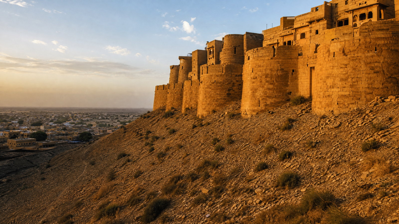
Jaisalmer Fort, or Sonar Qila, is a sandstone hill town in the Thar rather than a sealed monument. Founded in the twelfth century, it forms part of the Hill Forts of Rajasthan and remains inhabited, with temples, lanes, homes and commerce inside its walls. Jain temples, defences and desert-adapted stone building reflect historic trade geography. Visitors share narrow streets with residents, worshippers, deliveries and conservation work. Its water and drainage needs are consequential, making care for an inhabited heritage place central to any visit.
Why this place matters
Go for a desert fort whose urban life continues within its defences. Jaisalmer contrasts with museum-like palace visits: sacred buildings, dwellings and commerce demonstrate living heritage. It also anchors a wider stay exploring havelis, desert ecology and fossils. The trade-off is fragility. Crowding, waste and unmanaged water affect the fort, while narrow stepped lanes challenge mobility. Stay unhurried, follow local rules and use authorised arrangements for surrounding desert visits. Its value lies in shared, respectful observation, not unrestricted access. Respectfully.
Lake city and cultural landscape · Udaipur district, southern Rajasthan
Udaipur Lake City
Udaipur sits in the Girwa Valley among Aravalli hills, where lakes, dams, palaces, ghats, gardens and older neighbourhoods form a linked water-and-city landscape. Founded in 1553 as the Mewar capital, it differs from the sandstone west through its basin setting and engineered lakes. City Palace rises above Lake Pichola, while Fateh Sagar and smaller lakes show how storage and urban form coexist. Shilpgram adds a regional crafts context. The city’s visual drama depends on catchments, water levels and the living old city.
Why this place matters
Go for Rajasthan’s clearest combination of court architecture, water engineering and green Aravalli relief. Udaipur suits a slower urban base after the dry west, with museums, temples, crafts and walks in reach. The trade-off is popularity around the principal lakefront, where roads are tight and views busy. Monsoon light and fuller lakes can appeal, but rain may disrupt walking. Spread time across Lake Pichola, City Palace, a neighbourhood walk and a quieter lake or craft space rather than treating it as one sunset stop.
Hill fort and archaeological landscape · Chittorgarh district, southeastern Rajasthan
Chittorgarh Fort
Chittorgarh Fort spreads across a high hill above the modern city, a Mewar stronghold associated with court history, warfare, devotion and layered folklore. Part of the Hill Forts of Rajasthan serial property, it contains towers, palaces, temples, reservoirs, gates and open ground: a former fortified urban world. Vijay Stambh and Kirti Stambh express different commemorative traditions, while Gaumukh shows why water storage mattered on a hill. Its scale rewards historical nuance; popular stories should not erase its Jain, Hindu, military and water-management histories.
Why this place matters
Go for fort scale and complexity. Chittorgarh makes the political and environmental logic of a Rajput hill capital visible, from guarded approaches to reservoirs and sacred precincts. It pairs naturally with Udaipur or Kumbhalgarh but needs more than a roadside stop. Exposure is substantial, shade limited and paths rocky or stepped. Start early, plan around heat and allow time for towers, temples and water structures. The value lies in reading many eras in one landscape, not repeating simplified legends. Deliberately.
Hill fort and wildlife sanctuary · Rajsamand district, Aravalli region
Kumbhalgarh Fort and Sanctuary
Kumbhalgarh places a fifteenth-century Mewar fort in a forested Aravalli setting. Long ramparts follow difficult terrain, enclosing palaces, temples, water structures and settlement traces; it is one of the six Hill Forts of Rajasthan. The adjacent sanctuary extends the experience into dry forest, ravines and habitat for leopard, hyena, deer and birds. The place shows how topography served defence and still shapes travel. Fort and sanctuary are separately managed spaces, so routes and operating conditions should not be assumed to align.
Why this place matters
Go for the meeting of Mewar architecture and Aravalli ecology. Kumbhalgarh feels terrain-driven: walls, gates and viewpoints follow the ridge rather than override it. It works from Udaipur with an overnight or within a slower southern loop. The trade-off is exertion and timing. Hill gradients, ramparts and forest access make it more demanding than a city museum, and wildlife is never assured. Give the fort a focused visit and approach the sanctuary quietly, with current permissions and realistic expectations. Unhurriedly.
Pilgrimage town and sacred lake landscape · Ajmer district, central Rajasthan
Pushkar
Pushkar is a compact pilgrimage town around a sacred lake, 52 bathing ghats and a dense ring of temples. Set between low hills near Ajmer, it contrasts with Jaipur’s breadth through its pedestrian scale and active ritual life. The Brahma temple, lakefront steps, Varaha temple and viewpoints are experienced beside worship, water rituals, markets and seasonal gatherings. Its fair period can intensify the town, but Pushkar remains devotional year-round. Its value lies in observing a living sacred geography with restraint, not treating ghats or worshippers as scenery.
Why this place matters
Go for a legible sacred-town landscape where water, hill, temple and lanes form a coherent whole. Pushkar complements Ajmer and Jaipur, and its compactness rewards a slower overnight instead of a hurried excursion. The trade-off is sensitivity and crowding: shrines and ghats have rules for footwear, dress, photography and movement, while fair dates change traffic and noise. Walk the lake at calmer hours, enter shrines when appropriate and let devotional rhythm set the pace rather than following a rigid checklist.
Historic merchant-town cultural landscape · Jhunjhunu, Sikar and Churu districts, northern Rajasthan
Shekhawati Painted Haveli Towns
Shekhawati is a cultural landscape of merchant towns, not one monument. Across Mandawa, Nawalgarh, Fatehpur, Ramgarh and neighbouring settlements, nineteenth- and early twentieth-century havelis, temples, wells, cenotaphs and forts retain painted façades and interiors. Imagery ranges across myth, local memory, flora, animals and wider-world encounters. These towns also show dry-climate building through courtyards, shade, reservoirs and close lanes. Conditions vary by property, and many houses remain private, altered or fragile. See several towns and respect thresholds. Surfaces reward slow looking.
Why this place matters
Go beyond royal capitals to encounter painted merchant architecture and town life. Shekhawati rewards attention to mural detail, trade wealth and domestic building. It is quieter than Jaipur, though town-to-town distances and uneven conservation make a vehicle and flexible pace useful. Do not expect every haveli to be open, restored or interpreted. Two nights reveal meaningful differences; one stop gives only a surface impression. Treat occupied houses as homes, seek permission before entering courtyards and never touch painted walls. Respectfully.
Tiger reserve and forest hill fort landscape · Sawai Madhopur district, southeastern Rajasthan
Ranthambore Tiger Reserve
Ranthambore combines dry deciduous forest, lakes, crags and meadows where the Aravalli and Vindhyan systems meet. It is a major tiger reserve but also habitat for deer, langurs, birds, reptiles and other predators, with tenth-century Ranthambore Fort rising above the forest. Ruins, water and dhok woodland give it cultural as well as ecological texture. Protected status sets the terms: entry follows managed routes and schedules, and the landscape’s value does not depend on seeing a tiger. Sawai Madhopur offers rail access and a practical base.
Why this place matters
Go for protected dry forest alongside a major hill fort. Ranthambore complements Jaipur or Bharatpur by bringing a nature-based contrast to city days. The trade-off is expectation management: wildlife can be distant, hidden or absent, and an outing is not a private expedition. Heat builds quickly, management can alter access and popular months are busy. Plan multiple outings only if habitat, birds and landscape matter as much as a flagship species. Keep fort, reserve and community edge distinct in your understanding.
Wetland national park · Bharatpur district, eastern Rajasthan
Keoladeo National Park
Keoladeo National Park at Bharatpur is a compact, managed mosaic of grassland, woodland, swamps and shallow water within a populated setting. It is recognised for migratory waterfowl on the Central Asian flyway and supports resident breeding birds and other wildlife. Dykes and sluices create varying depths, while rainfall and external water influence habitat condition. Its former hunting-reserve history should not eclipse its conservation role or community-linked guiding traditions. This is a close study of birds, water and habitat rather than a grand scenic wilderness.
Why this place matters
Go for patient bird observation and a lesson in how managed water shapes wetland habitat. Keoladeo works with Bharatpur’s rail connections and routes toward Jaipur, but it asks for a slower pace than fort touring. Species mix, water levels and visibility shift by season and year, so there is no fixed checklist. Winter often brings migrant concentrations; other seasons still reward attention to residents and vegetation. Use quiet, low-impact movement, give nests distance and never use playback to draw birds closer.
Desert protected landscape · Jaisalmer and Barmer districts, western Rajasthan
Desert National Park
Desert National Park protects a large cross-section of the Thar across Jaisalmer and Barmer: dunes, gravelly and rocky ground, thorn vegetation, grassland, sparse settlements and fossil-bearing terrain. Its scale corrects the idea of desert as blank scenery. The landscape supports chinkara, foxes, reptiles and notable birds, including the threatened Great Indian Bustard; Akal Wood Fossil Park records a far older environmental history. Villages and long-established land use are part of the wider setting. It is a conservation landscape, not a free-roaming playground.
Why this place matters
Go to encounter the Thar as a biologically and geologically complex place, not simply a dune backdrop. The park pairs meaningfully with Jaisalmer Fort: one explains desert urban adaptation, the other habitat, fossils and communities. The trade-off is exposure and uncertainty. Heat, wind and distance require preparation; wildlife is elusive; and management may restrict access. A guided low-impact visit can reward landscape, birds and natural history without a major sighting. Stay on authorised routes and leave no trace on fragile ground.
Aravalli hill station and pilgrimage landscape · Sirohi district, southwestern Rajasthan
Mount Abu
Mount Abu is Rajasthan’s principal hill station, rising to about 1,722 metres in the Aravalli range with forest, rock formations, lake views and temple architecture far removed from the Thar. The eleventh- to thirteenth-century Dilwara Jain temples are central to its religious and artistic significance. Nakki Lake, Guru Shikhar and the sanctuary offer different readings of the upland setting. Mount Abu is a living town and pilgrimage area with crowds, steep paths and protected forest. Altitude moderates conditions but does not eliminate sun, rain or mobility concerns.
Why this place matters
Go for a highland counterpoint to hot plains and desert cities. Mount Abu works after Udaipur or Kumbhalgarh, combining Jain architecture, forest-edge scenery and viewpoints. The trade-off is that popular lake and temple areas can crowd quickly, weather changes and slopes or steps are common. Balance a respectful temple visit with quiet time in the hill landscape rather than collecting every viewpoint. Dress appropriately at shrines and keep forest expectations realistic: sanctuary habitat does not guarantee wildlife encounters. Move slowly.
Season and pace
Choose a date window for the experience, then keep a fallback.
October–March is generally easiest for cities, forts, desert walks and birding. Official statewide guidance places much winter weather around 10–30°C, though desert nights can feel cold. Fairs, pilgrimages and school holidays can concentrate demand.
April–June is hot and dry; official guidance notes peaks near 48°C. In the west, reduce outdoor activity to early hours, use shade and water, and heed heat alerts. July–September brings the main monsoon influence, roughly 100–165 mm in the statewide planning range but unevenly distributed. Aravalli and southeastern landscapes green up; slick stone, short intense rain and local access changes remain possible. Confirm current forecast, alerts, roads and conservation closures locally.
Movement and planning
Distance on a map is not the same as usable travel time.
Moving through the region
Jaipur, Jodhpur and Udaipur are useful air and rail gateways; rail also reaches Sawai Madhopur, Bharatpur, Ajmer and Chittorgarh. Buses and hired vehicles connect the state, but narrow town approaches, fort climbs, desert roads and rain-affected stretches add time. Do not depend on tight connections after a long drive.
Old quarters reward walking but often have cobbles, steps, slopes, crowding and vehicle restrictions. Travellers needing step-free routes should seek current details from each site; historic access is often partial. In protected areas, movement follows designated vehicles, tracks or guided routes.
Building a workable route
Choose by landscape rather than attempting a state-wide checklist. A first nine-to-twelve-day trip might combine Jaipur, Pushkar, Jodhpur and Udaipur, or Jaipur, Ranthambore and Bharatpur. Add Jaisalmer only with time for its western approach. A southern loop through Udaipur, Kumbhalgarh, Chittorgarh and Mount Abu suits hills, water and temple architecture; Shekhawati shifts the focus to painted merchant towns.
Carry sun protection, refillable water capacity, a winter-evening layer, grippy shoes and shrine-appropriate clothing. Timed entry, documents, routes, fees, closures and operating hours change; confirm through the relevant local or official channel near travel. Build a weather buffer and do not expect a wildlife outing to deliver a particular encounter.
Travel responsibly
The regional context includes its limits.
Water scarcity, heat, waste, urban growth and visitor volume affect Rajasthan’s heritage and ecosystems. Use refills where safe, avoid single-use plastic and leave no litter at lakes, dunes, temples or forts. In Jaisalmer, use water sparingly; at havelis, do not touch murals or enter private space uninvited.
In wildlife areas, follow the assigned route and guide, keep voices low, never feed or call animals and do not request off-route driving. Keep distance from birds and nests. Sacred water, ghats and temple interiors have rules for footwear, photography and dress; ask when unsure. Favour locally rooted craftspeople and guides, and adjust plans for alerts, crowding, closures or community requests rather than forcing access.
This is an evergreen regional guide. Weather, permits, closures, transport and local rules can change; confirm material conditions through the relevant local or official channel before travel.