South India · Union territory · PY
Puducherry
Puducherry is a discontinuous Union Territory whose four former French possessions span South India: Tamil-speaking Coromandel coast around Puducherry and Karaikal, Malayalam-speaking Mahe on the Malabar coast, and Telugu-speaking Yanam on a Godavari distributary in coastal Andhra Pradesh. The capital rewards unhurried walks through a Franco-Tamil streetscape, spiritual institutions, gardens and Bay of Bengal promenade; its hinterland adds an archaeological riverbank, wetland and estuary. Karaikal brings Cauvery-fed fields and Shaiva pilgrimage; Mahe, laterite slopes, intense southwest monsoon and an Arabian Sea estuary; Yanam, a riverine counterpoint. This is not one compact circuit. Use Puducherry city as a two- or three-day base and plan detached regions as separate journeys. Treat beaches, sacred spaces, wetlands and residential streets as lived environments, checking weather, sea conditions and access shortly before departure.
Regional notebook
Begin with the shape of the region.
Puducherry’s four separated regions share history, not continuous territory. The capital is the practical first base: seafront, heritage quarter, Ashram and Botanical Garden are walkable or a short ride apart. Arikamedu and Chunnambar add maritime and estuarine layers; Oussudu Lake offers a wetland contrast.
Karaikal, Mahe and Yanam are extensions within different surrounding states. Karaikal combines Cauvery-fed Tamil landscapes, temples and shore; Mahe is a lateritic Malabar estuary; Yanam a Godavari river town in coastal Andhra. Map distance understates travel time, so territory-wide itineraries need journey days.
Landscape
Geography changes the journey.
Puducherry and Karaikal lie on Tamil Nadu’s Coromandel coast; Mahe is on Kerala’s Malabar coast and Yanam in Andhra Pradesh. The capital is low and coastal, with red ferrallitic soil, black clay, coastal alluvium, and the Ariyankuppam and Chunnambar rivers. Oussudu is a freshwater wetland; Mahe combines an Arabian Sea estuary and lateritic hills; Yanam is a Godavari distributary landscape.
There is no high-altitude travel. Heat, humidity, uneven paving, heavy rain, tide and changing water are the practical limits. Use managed access and keep clear of erosion-prone edges, surf, channels and floodwater.
Living culture
Arrive as a guest, not an audience.
French association is real but incomplete without Tamil, Malayalam and Telugu worlds. French rule left architectural traces, while enduring South Indian religious, linguistic, craft and food traditions shape each enclave. Puducherry’s façades, courtyards and verandas adapt a mixed urban vocabulary to the tropics. The Ashram and Auroville add modern spiritual and experimental-community histories, but remain working communities.
Karaikal is associated with Tamil Shaiva traditions and Karaikal Ammaiyar; Thirunallar is active pilgrimage. Mahe is Malayalam-speaking and Malabar in character. Yanam is Telugu-speaking and river-oriented, with Hindu and Christian sites. Dress respectfully, ask before photographing people or rituals, and honour devotional queues, silence and community rules.
Curated regional atlas
Places that reveal different parts of Puducherry
This is a selective, geographically varied starting point rather than an exhaustive list. Use it to choose a coherent route, not to compress every place into one trip.
heritage urban quarter and seafront · White Town and Goubert Avenue, Puducherry city
French Quarter and Promenade
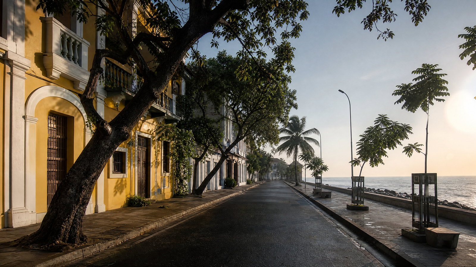
The French Quarter, often called White Town, is Puducherry’s most legible built record of its colonial and Franco-Tamil history. A rectilinear street pattern leads from shaded residential lanes to the Bay of Bengal promenade, where the French War Memorial, old harbour frontage and civic landmarks form a public seafront sequence. Its architectural interest lies in adaptation: shuttered façades, courtyards, verandas and tropical planting make a mixed vocabulary rather than a replica of France. The quarter remains residential, institutional and commercial, so its value comes from walking slowly and noticing scale, light and everyday use rather than treating it as an open-air set.
Why this place matters
Go for the clearest introduction to Puducherry’s urban identity, where sea, colonial-era planning, Indian coastal life and civic memory meet within a walkable area. It is a strong first or last stop, placing the Ashram, museum precinct, churches and promenade in relation. Early morning brings softer light and less heat; late afternoon is atmospheric but busier. This is among the region’s more approachable areas for limited time or mobility, although kerbs, traffic and uneven surfaces remain constraints. It rewards observation rather than an overpacked checklist.
living spiritual community · White Town, Puducherry city
Sri Aurobindo Ashram
Sri Aurobindo Ashram is a living spiritual community in central Puducherry, associated with Sri Aurobindo and Mirra Alfassa, known as the Mother. Its principal courtyard and samadhi are places of quiet contemplation rather than a conventional monument. The institution’s presence also extends into educational, cultural and service-oriented work across the town, helping explain why the capital’s spiritual life cannot be separated from its civic texture. A visit is best approached as a short, quiet pause within the heritage quarter. The modest scale and disciplined atmosphere are part of the experience, not a lack of spectacle.
Why this place matters
Go to understand a major twentieth-century strand of Puducherry’s intellectual and spiritual identity in its urban setting. It fits a nearby-quarter walk but requires another pace: its value lies in stillness, flowers, shade and careful use of a shared courtyard. Visitors interested in modern Indian thought, community institutions or contemplation will find more substance than those seeking dramatic architecture. Close to other central sights, it provides a practical low-heat interval within a day on foot, while retaining its own atmosphere.
experimental township and contemplative landmark · Auroville area, north of Puducherry city
Auroville and Matrimandir Viewing Point
Auroville is a dispersed experimental township across forested, semi-urban and coastal-edge landscapes, established around an idea of human unity. The gold-toned Matrimandir sits within its central Peace Area and is intended for individual silent concentration. For most short-stay visitors, the appropriate encounter is through the Visitors Centre, interpretation material and the regulated viewing point rather than an attempt to move freely through residential communities. The setting matters as much as the building: planted roads, regenerating landscape and scattered settlements make Auroville feel unlike a compact attraction or a suburb of Puducherry.
Why this place matters
Go for a counterpoint to the capital’s colonial street grid: Auroville expresses a modern, international and ecological vision rooted in the same region. It suits design, community-planning and contemplative interests, not a hurried photo stop. The viewing point shows Matrimandir and its gardens without disrupting the concentration space. With time, orientation material clarifies the township’s complexity. It is spread out and regulated, so a short visit requires realistic expectations, advance awareness, practical planning and unhurried pacing. Prepare and arrive unhurried.
historic botanical garden · Southwest Puducherry city
Puducherry Botanical Garden
Established by the French administration in 1826, Puducherry Botanical Garden is an approximately 11-hectare living collection in the city rather than a decorative stop alone. Its development began with testing cultivable plants under local conditions and evolved into a broad collection of indigenous and introduced trees, palms, medicinal plants, cacti and succulents. Mature specimen trees and the garden’s shaded geometry offer a useful ecological lens on a hot coastal city. As a government-managed garden with educational aims, it connects colonial-era botanical history to contemporary plant conservation and public green space.
Why this place matters
Go for shade, plant diversity and historical context without leaving the city. It fits well between exposed promenade or heritage-quarter walks and shows how tropical horticulture shaped Puducherry’s public realm. Naturalists can focus on labelled collections and seasonal flowering; families and casual visitors can enjoy a slower green interval. This is cultivated urban landscape rather than wilderness, but its old trees, varied forms and botanical purpose give it depth beyond an ordinary park visit for varied interests. Allow unhurried exploration.
archaeological site and riverbank landscape · Ariyankuppam area, south of Puducherry city
Arikamedu Archaeological Landscape
Arikamedu occupies a low riverbank landscape on the Ariyankuppam River south of the capital. It is associated with early historic maritime exchange and has long been central to study of South India’s connections across the Indian Ocean, including trade with the Roman world. The significance lies in archaeological evidence and the setting of a former port landscape, not in a fully reconstructed visitor complex. Vegetation, riverbank conditions and the fragmentary nature of remains demand imagination and care. It is best regarded as an archaeological landscape whose meanings are still protected and interpreted through research, rather than as a place to explore freely.
Why this place matters
Go beyond the French period to encounter an older maritime layer in Puducherry’s story. Arikamedu rewards travellers interested in archaeology, trade networks, beads, ceramics and riverside settlement patterns; it pairs with Chunnambar or the city museum. Its restrained presentation makes preparation useful: read the landscape and respect conservation boundaries rather than expecting grand standing ruins. It is less suited to a rushed first itinerary but memorable for historically minded visitors who value context, research and protected place. Check access beforehand.
estuary and beach landscape · Nonankuppam, south of Puducherry city
Chunnambar Estuary and Paradise Beach
Chunnambar is where a backwater landscape approaches the Bay of Bengal south of Puducherry. The boat-house area is the usual gateway to the riverine setting and the sandy stretch commonly known as Paradise Beach. This is not simply a beach add-on: the appeal comes from the contrast between calm-looking inland water, planted banks, boat movement and an exposed marine shoreline. The estuary’s shape, sand and access are dynamic, reflecting monsoon, tide and management conditions. It is therefore an appropriate place to slow down, observe water and birdlife from a distance, and treat boat travel as weather-dependent.
Why this place matters
Go for Puducherry’s clearest river-to-sea transition and a break from dense city. It suits travellers who prefer landscape to shopping or urban heritage and combines sensibly with Arikamedu on a southern day. The boat approach can make the beach feel removed from roads, but operations are not assured in all weather. Early or late daylight reduces heat and gives softer light. Water access, sea state and crowd levels remain variable, so leave time for the landscape rather than a fixed schedule.
freshwater wetland and bird sanctuary · Oussudu/Ousteri, west of Puducherry city
Oussudu Lake Bird Sanctuary
Oussudu Lake, also called Ousteri, is a freshwater wetland shared across the Puducherry–Tamil Nadu boundary and protected in part as a bird sanctuary. The wetland supports resident and migratory waterbirds, including herons, storks, pelicans and ducks, and is recognized for its importance as a wintering habitat. Its character changes markedly with rainfall, water level and season: open water, reeds, mud edges and bird concentrations are never a guaranteed tableau. Unlike the urban promenade, this is a habitat first. Its quietest rewards are distant observation, changing light and an understanding of how a large wetland functions beside a growing city.
Why this place matters
Go for a nature-focused counterbalance to Puducherry’s built heritage. Birders can use post-monsoon and winter as broad planning windows; others will value the open horizon and wetland ecology. It suits an early half-day, leaving later hours for shaded city sites. Wildlife movement, water levels, viewing points and weather shape the visit more than a standard timetable. Patience and binoculars add more value than trying to approach birds closely, and flexibility respects habitat and conditions. Expect changing sightings, conditions and views.
Shaiva pilgrimage temple · Thirunallar, Karaikal region
Thirunallar Dharbaranyeswarar Temple
Thirunallar’s Dharbaranyeswarar Temple is an active Shaiva pilgrimage centre in the Karaikal region, dedicated to Dharbaranyeswarar and closely associated with Saneeswara. Temple tradition connects the site with King Nala and the sacred tank known as Nala Theertham; it is also counted among the Sapta Vidanga shrines. Its importance is devotional, ritual and regional, not only architectural. On major astrological and festival occasions, the temple and surrounding town can receive exceptionally large pilgrim flows. A respectful visit recognizes that worship, queues, bathing customs and timing are governed by religious practice rather than by a visitor’s schedule.
Why this place matters
Go for one of the territory’s major living pilgrimage contexts and a direct encounter with Tamil Shaiva practice beyond the capital’s heritage zone. The temple adds depth to a Karaikal trip and pairs with Karaikal Ammaiyar Temple to trace distinct Tamil devotional histories. Observe its ritual rhythm, sculpture and civic role without trying to replicate rituals. Quiet observation is likelier outside major festival and planetary-transition periods, but crowding and timings always require confirmation before planning a visit or travel day.
Shaiva heritage temple · Karaikal town, Karaikal region
Karaikal Ammaiyar Temple
Karaikal Ammaiyar Temple is dedicated to Punithavathi, revered as Karaikal Ammaiyar, one of the sixty-three Tamil Shaiva Nayanmars and the only woman among them. The temple anchors a townscape that includes other shrines and the nearby Ammaiyar Thirukulam, giving a compact introduction to Karaikal’s devotional geography. The annual Mangani observance, associated with the Tamil month of Aani, is a major expression of this literary and religious inheritance. Karaikal’s history as a maritime town and former French possession is present in the wider region, but Ammaiyar’s legacy reveals a deeper Tamil spiritual and poetic identity.
Why this place matters
Go to encounter a female saint’s place in Tamil religious memory and early devotional literature, often missed by itineraries focused on French architecture or beaches. The temple adds cultural and intellectual weight to Karaikal when approached with time to understand rather than photograph. Combine it with Thirunallar or the shore, while allowing for its living ritual context. Visitors interested in women’s religious history, Tamil bhakti and small-town sacred landscapes have a distinctive reason for this separate journey and its patient, respectful exploration.
river estuary and waterfront · Mahe town, Mahe region
Azhimukham, Mahe Estuary
Azhimukham is the meeting place of the Mayyazhi River and the Arabian Sea in Mahe, the territory’s small Malabar enclave. A riverside walkway links the estuary area toward Mahe Bridge, while Tagore Park and the regional administrative precinct sit nearby. The scene is defined by moving water and weather: a river mouth, sea horizon, laterite-backed town and monsoon clouds rather than the flat Coromandel shore of Puducherry city. Mahe’s scale makes this a particularly useful orientation point, showing why the enclave belongs geographically to the Malabar coast even as it remains part of Puducherry.
Why this place matters
Go for the territory’s strongest west-coast contrast. Azhimukham rewards a quiet waterfront walk, changing light and appreciation of estuary geography; it is not a resort beach. Pair it with Mahe’s shrine and hillock for a compact, landscape-led day. Visitors familiar only with Puducherry city will immediately notice different language, rainfall, vegetation and coastal feel. Southwest-monsoon drama can be beautiful, but intense rain, wind and slippery surfaces may sharply limit comfort and require flexible timing during a visit. Check conditions beforehand.
Christian pilgrimage shrine · Mahe town, Mahe region
St. Teresa’s Shrine, Mahe
St. Teresa’s Shrine is one of Mahe’s principal religious landmarks and a focal point of the town’s Catholic heritage. The shrine’s importance is especially visible during the Fête de Mahe, when visitors from different backgrounds join a major local observance. Within a territory known for French colonial associations, the shrine demonstrates how Mahe’s history is also Malabar, Malayalam-speaking and deeply shaped by living Christian practice. Its position in compact Mahe makes it easy to include with the riverfront and hillock, but the atmosphere can change significantly between an ordinary day and a festival period.
Why this place matters
Go for a living religious and community context, not a detached architectural monument. The shrine helps visitors read Mahe as a town where French-era history, Malabar culture and Catholic devotion intersect. It suits a respectful short stop within a Mahe walk. Festival periods can carry considerable cultural energy; other days are quieter and reflective. Its value lies in understanding a local sacred institution on its own terms, rather than seeking access everywhere, and in respecting the congregation’s routines and shared space.
riverfront and civic landscape · Yanam town, Yanam region
Yanam Godavari Riverfront and Ferry Road
Yanam sits beside the Gauthami Godavari, a distributary that continues toward the Bay of Bengal after passing the town. Ferry Road and the riverfront are the clearest places to understand this Telugu-speaking enclave’s water-based geography: coconut-lined banks, broad river views and connections to the surrounding Konaseema region replace the open sea promenade of the capital. The historic ferry function and later bridge infrastructure underscore that this is a working regional crossing as well as a visitor viewpoint. Yanam’s French past is present in the town’s heritage, but the river is the stronger organizing feature of daily landscape and movement.
Why this place matters
Go for a quieter, distinctly riverine perspective on Puducherry. The riverfront shows how the territory changes beyond the Tamil coast: language, vegetation, hydrology and visual scale shift. Combine it with Yanam’s Venkateswara temple and St. Ann’s church for a compact cultural circuit. Sunrise or cooler late-day light is preferable to midday. The river is not a controlled promenade attraction; weather, water flow and local transport activity shape the experience, so use public space patiently and remain adaptable. Check conditions beforehand.
living religious heritage precinct · Yanam town, Yanam region
Yanam Venkateswara Temple and St. Ann’s Church
Yanam’s Alamelumanga Sahita Shri Venkateswara Swamy Temple, widely known as the Venkanna Babu Temple, and St. Ann’s Catholic Church present two important religious histories within a small town. The temple is associated with a major annual Venkanna festival and retains sculptural links to the region’s earlier artistic traditions. St. Ann’s, built in a European style during the French period, carries a different strand of Yanam’s layered heritage and hosts an annual March observance. Seen together, they make clear that Yanam is not merely a French outpost: it is a Telugu town with Hindu and Christian sacred geographies shaped by regional history.
Why this place matters
Go to understand Yanam through active worship rather than colonial imagery alone. The pair offers a concise, respectful route into the town’s plural cultural life, with instructive architectural contrast. Temple visitors may be drawn by the Venkanna festival; the church recalls French missionary-era influence. Both require slower observation. Festival days can be meaningful but do not suit visitors seeking easy circulation, photography or guaranteed quiet; ordinary days may allow more reflective observation, more careful orientation and respectful use of shared sacred space.
Season and pace
Choose a date window for the experience, then keep a fallback.
One calendar does not fit all four regions. Puducherry, Karaikal and Yanam are generally most comfortable from December to February, though northeast-monsoon rain and cyclonic systems can disrupt plans. March to June is hot and humid; Yanam’s pre-monsoon heat can be severe. Puducherry receives much rain with the northeast monsoon; Mahe has intense southwest-monsoon rain roughly June to September.
Post-rain and winter can suit Oussudu bird observation, but water and access fluctuate. Build indoor alternatives into wet days, start exposed walks early, carry water and sun protection, and reassess water activity whenever warnings are issued.
Movement and planning
Distance on a map is not the same as usable travel time.
Moving through the region
Puducherry city is easiest without a private vehicle. The French Quarter, promenade, Ashram and garden connect by foot or short local ride, although heat, crossings and variable paving affect accessibility. Roads remain central; check rail and airport services close to travel.
Detached regions need different approaches: Karaikal is a road leg, Mahe uses Kerala’s rail-and-road network, and Yanam coastal Andhra connections. Public transport adds transfer uncertainty. On a short trip, focus on the capital. For a territory-wide journey, reserve travel days and confirm timetables, road conditions, water operations and restrictions through relevant official or local channels.
Building a workable route
Begin with two capital days: one for the heritage quarter, promenade, Ashram and garden; another for Auroville, Arikamedu or Chunnambar. Add Oussudu early for a nature contrast. Three or four days prevent midday rushing. Choose Karaikal for pilgrimage and Tamil literary heritage, Mahe for Malabar river-and-sea scenery, and Yanam for a Telugu-speaking Godavari setting.
Confirm hours, passes, religious calendars, photography rules, closures, water activity and transport the day before. Matrimandir arrangements are controlled and can change. Carry modest clothing, water, rain cover and removable footwear; leave buffer time for detached-region transfers.
Travel responsibly
The regional context includes its limits.
The territory’s appeal rests on residential streets, active worship, wetlands, dunes, estuaries and riverbanks. Keep quiet at the Ashram and Matrimandir, obey photography and drone restrictions, and never enter restricted grounds. In wetlands, observe from allowed areas, avoid playback calls, do not feed wildlife and keep away from nesting birds. Carry waste out and avoid single-use plastic near water.
Do not enter sea, river or estuary water because it looks calm: currents, tide, discharge and closures change risk. Use authorized operations only when conditions permit, wear required safety gear and accept cancellations. Follow sacred-site directions, obtain consent before photographing worshippers, and purchase from legitimate local makers without pressing residents for access to homes or community spaces.
This is an evergreen regional guide. Weather, permits, closures, transport and local rules can change; confirm material conditions through the relevant local or official channel before travel.