Northeast India · State · NL
Nagaland
Nagaland is a compact but topographically demanding hill state on India’s eastern frontier, where routes between valleys matter as much as map distance. Kohima, the capital, is a useful cultural and historical base; Dimapur is the principal lowland transport gateway. Beyond them, the state opens into markedly different Naga homelands: Angami terraced country around Kohima, Ao villages above Mokokchung, Konyak settlements in Mon, Lotha landscapes around Wokha, and the far-eastern forests beneath Mount Saramati. It is a cross-section of war memory, vernacular architecture, village-led conservation, craft, reservoir birdlife, rainforest, and high mountain terrain. The strongest trip is usually unhurried and regional rather than a rapid circuit. Kohima and its nearby cultural landscapes suit first visits and short breaks; Doyang adds a seasonal wildlife focus; Mokokchung and Mon reward time for community context; Kiphire is for prepared mountain travellers. Roads, rain, festivals, village protocols, and entry requirements can reshape plans. Build spare time, use locally current advice, and approach each community as a living place rather than a backdrop.
Regional notebook
Begin with the shape of the region.
Nagaland, inaugurated as India’s sixteenth state in 1963, occupies 16,579 square kilometres of the eastern hills. Its 17 districts contain many distinct communities rather than one uniform culture. English is official, Nagamese often connects speakers, and local Naga languages and dialects remain central to identity. The visitor experience is intensely local: village history, customary institutions, church calendar, agricultural rhythm, and conservation rules all matter.
Treat the state as an upland mosaic linked by Dimapur, Kohima, and long mountain roads, not as a festival checklist. Archaeological pillars, wartime memory, heritage interpretation, museums, craft, forests, reservoirs, and mountain walks each offer a different entry point. These selected places are a cross-section, not an exhaustive inventory; use them to build a slower route that prioritizes current local guidance and community consent.
Landscape
Geography changes the journey.
Nearly all of Nagaland is mountainous. The Naga Hills rise from the Brahmaputra-side lowlands and climb southeastward into the Patkai system on the Myanmar frontier. Mount Saramati in Kiphire reaches about 3,826 metres, while Kohima is about 1,444 metres. Rivers include the Doyang and Dikhu in the north, the Barak to the southwest, and tributaries of the Chindwin in the southeast.
Terrain governs itinerary design. Dimapur’s lower, warmer plain is the practical arrival point, but most cultural and scenic destinations require winding uphill travel. Short map distances may become long days after rain, roadworks, fog, or landslips. High ridges can be cool and exposed while Peren’s tropical forest has entirely different conditions from Dzukou grasslands or the Saramati approaches.
Living culture
Arrive as a guest, not an audience.
Nagaland’s cultural richness lies in difference. Major communities include Angami, Ao, Chakhesang, Chang, Konyak, Lotha, Phom, Pochury, Rengma, Sangtam, Sumi, Yimkhiung, Zeliang, and others, with distinct languages, dress, material traditions, festivals, and village histories. Agriculture remains a social anchor, and many observances relate to sowing, harvest, food, music, and collective work. Christianity is important in contemporary public and family life alongside customary knowledge.
Learn the host community’s name and context rather than treating ‘Naga culture’ as one display. Textiles, basketry, woodwork, songs, food, and morung forms carry local meaning. Ask before photographing people, homes, worship, heirlooms, or ceremonies; living culture is not public performance on demand.
Curated regional atlas
Places that reveal different parts of Nagaland
This is a selective, geographically varied starting point rather than an exhaustive list. Use it to choose a coherent route, not to compress every place into one trip.
state museum · Bayavu Hill, Kohima District
Nagaland State Museum
Nagaland State Museum is Kohima’s essential orientation point for the state’s material and social histories. Open to the public since 1970, it presents artefacts, attire, clan motifs, jewellery, musical instruments, models, and dioramas that introduce the cultural diversity of Naga communities. Morung models help visitors notice architectural differences that can otherwise be easy to miss in a short journey, while paintings and displays connect historical forms to continuing creative practice. It is a compact, interpretive counterweight to travelling quickly through villages: objects are given context rather than being reduced to decoration.
Why this place matters
Visit early in a Nagaland itinerary to build visual and historical vocabulary before encountering living communities. The museum makes later visits to Kohima, Kisama, Khonoma, Mokokchung, or Mon more legible, from weaving and bamboo instruments to house forms and festival references. It also works well for travellers who need a low-exertion cultural stop in a steep city. The value is not a claim to speak for every community; it is an accessible starting framework that encourages more careful listening and locally informed questions beyond the galleries.
war cemetery and memorial landscape · Kohima, Kohima District
Kohima War Cemetery
Kohima War Cemetery occupies part of Garrison Hill, where the Japanese advance into India was halted in April 1944 during the Burma Campaign. The landscaped cemetery preserves the former deputy commissioner’s bungalow tennis court through white concrete lines and contains 1,420 Commonwealth Second World War burials, alongside a cremation memorial for 917 Hindu and Sikh soldiers whose remains were cremated according to their faith. Its terraces, regimental memorials, and inscriptions make the site both a burial ground and a precise geographic record of a pivotal battle.
Why this place matters
This is the clearest place to understand why Kohima has international wartime significance without turning conflict into spectacle. The cemetery asks for slow, quiet attention to Indian, British, and other Commonwealth lives, as well as to the civilian landscape in which the battle unfolded. It pairs productively with the State Museum because one locates Kohima within global wartime history and the other introduces Nagaland’s broader cultural plurality. The measured design and hill setting make it suitable for reflective travellers rather than those seeking a conventional monument stop.
cultural interpretation village · Kisama, Kohima District
Kisama Heritage Village
Kisama Heritage Village lies on a slope outside Kohima and is designed around traditional Naga village forms, including morung-style structures. It is best known as the main setting for the Hornbill Festival, when cultural programmes, indigenous games, craft activity, food, and performances bring communities from across the state into a shared public setting. Outside festival time, the built environment offers a useful introduction to architectural vocabulary and the state’s wish to safeguard diverse heritage. It should not be mistaken for a substitute for the many autonomous, lived villages represented there.
Why this place matters
Kisama is the most efficient place to encounter the breadth of Nagaland’s public cultural presentation, especially for travellers with limited time. During festival season, it can offer concentrated access to music, food, textiles, and programming that would be impossible to assemble independently. At quieter times, it provides a visual bridge to village architecture before travelling further. The trade-off is scale and crowds: a festival visit is energetic and curated, while a village visit requires more time, invitation, and attention to local rhythms. Both approaches have value when expectations are clear.
high-elevation valley and trekking landscape · Kohima District and the Nagaland–Manipur border area
Dzukou Valley
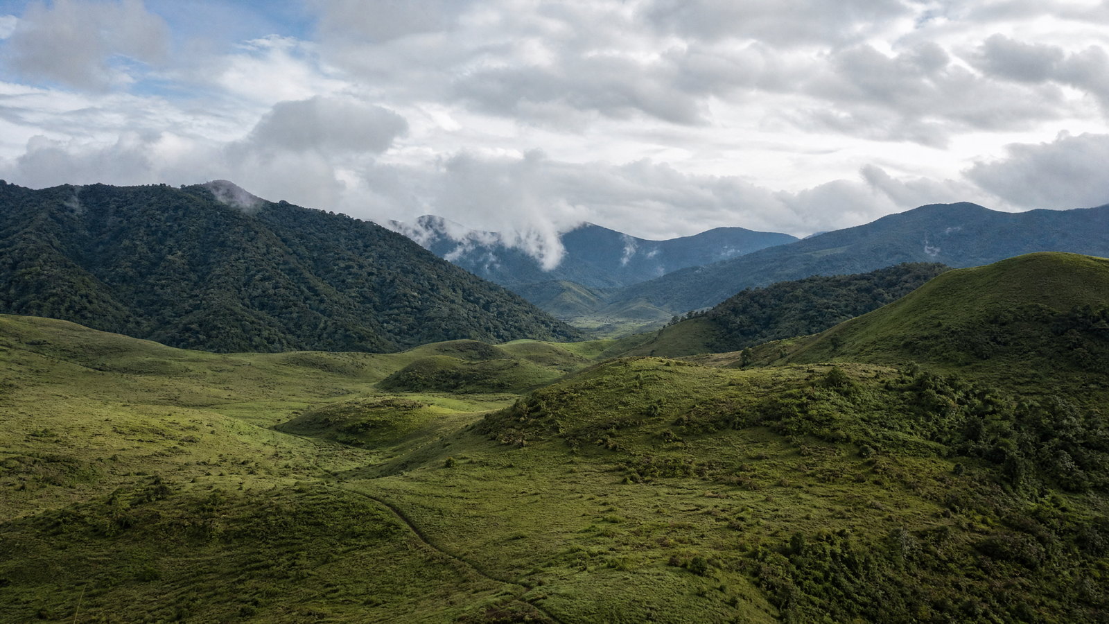
Dzukou Valley is a high, folded grassland and forest landscape between Nagaland and Manipur, at roughly 8,045 feet in the official tourism description. Its shallow stream, rolling knolls, and seasonal wildflower displays give it a markedly different character from the densely settled ridges around Kohima. The celebrated Dzukou lily is associated with the early monsoon floral period. Approaches from the Nagaland side are proper mountain walks through forest and steep terrain, not a roadside lookout; route length, footing, and exposure make the valley a serious day or overnight objective.
Why this place matters
Go for the contrast: after villages, memorials, and town roads, Dzukou offers a spacious upland landscape shaped by weather, grass, and contour. It rewards fit walkers who value a destination where the journey is integral to the experience. The most photogenic flower period coincides with wet, slippery conditions, whereas drier months are usually easier underfoot but less floral. That trade-off is central to planning. A local guide provides route judgement and reduces the chance of straying in fog; a conservative itinerary preserves time to turn back if weather, trail condition, or access advice changes.
Angami heritage and community-conservation village · Kohima District
Khonoma Village
Khonoma is an Angami village in the hills west of Kohima, known for terraced cultivation, a long history of resistance to British rule, and a widely discussed community conservation initiative. Its landscape is a working conjunction of settlement, stone-edged fields, alder-based farming knowledge, forest, and village governance. The Khonoma Nature Conservation and Tragopan Sanctuary emerged from local concern about wildlife loss, including Blyth’s tragopan. A fort inscription recalls the nineteenth-century conflict history, while the present-day village demonstrates that conservation is negotiated through community decisions rather than imposed scenery.
Why this place matters
Khonoma is one of Nagaland’s strongest places for understanding how heritage, farming, political memory, and conservation occupy the same slopes. It suits travellers who want more than a quick photograph of terraces: a guided walk can introduce landscape stewardship, village history, and the practical limits of access in a living settlement. It also provides a useful counterpoint to Kisama’s curated representation. The experience depends on respectful pacing and local permission; wildlife, farming work, homes, and community institutions should not be treated as open displays or guaranteed encounters.
archaeological ruins · Dimapur, Dimapur District
Dimapur Kachari Ruins
The Dimapur Kachari Ruins are sandstone remnants of the former Kachari kingdom, whose presence in the area predates the thirteenth century according to the district administration. The most recognizable elements are carved, mushroom-domed pillars, generally about eight to ten feet high, along with V-shaped memorial forms. Carvings of birds, animals, flowers, spearheads, and other motifs survive amid the wider traces of temples, embankments, and baths. In a state often introduced through hill cultures, these lowland ruins provide a different historical layer: an urban archaeological landscape close to the modern transport gateway.
Why this place matters
This is an efficient first or last cultural stop because it places Dimapur’s rail-and-air gateway within a much longer regional history. The pillars are visually distinctive, but their value lies in noticing how archaeology intersects with a busy contemporary city and a multi-layered past. It is especially worthwhile for travellers who intend to move directly to Kohima and want a grounded sense of the lowland–upland transition. Visit with patience and modest expectations: the site is not an expansive monumental complex, and its context is more rewarding when read slowly rather than rushed.
craft village · Chümoukedima District
Diezephe Craft Village
Diezephe is a craft-focused village near Dimapur where many households work with handloom, wood carving, bamboo, and cane. District documentation identifies it as a community of skilled weavers and craftspeople, with knowledge passed through families. The village offers a grounded way to see how material culture is made in a semi-rural setting rather than only displayed in a shop or festival pavilion. Its strength is process, skill, and continuity: weaving structures, local materials, and everyday work reveal why textiles and woven objects are central to Nagaland’s visual language.
Why this place matters
Choose Diezephe for a maker-centred cultural stop close to the transport gateway. It can complement the State Museum’s historical objects by showing contemporary craft practice and help travellers understand that a textile or bamboo object carries labour, technique, and family knowledge. It is a more suitable choice than souvenir-only shopping for visitors who want to learn respectfully. The experience should remain invitation-based: artisans may be working, private, or unavailable, and the presence of crafts does not create an entitlement to photograph, handle, or commission work on demand.
national park · Peren District
Intanki National Park
Intanki National Park is a 202-square-kilometre protected forest in Peren district, declared a national park in 1993. Its dense tropical and subtropical vegetation forms a critical forest patch connected with the Dhansiri Reserved Forests of neighbouring Assam. The Forest Department identifies habitat for species including hoolock gibbon, Asian elephant, clouded leopard, and wild buffalo, alongside varied plant life. These are conservation values, not a promise of sightings. The park’s significance is its contiguous forest ecology and the strict protection needed for wildlife, rather than easy wildlife-viewing infrastructure.
Why this place matters
Intanki is for travellers who value a protected forest as a place to learn about habitat rather than collect animal encounters. It broadens a Nagaland journey beyond high ridges and cultural villages into lowland rainforest ecology, making the link between forest continuity and species survival tangible. Birders and naturalists may find the less commercial character appealing, but should accept that dense forest makes observation uncertain. The right expectation is quiet, regulated nature time, guided by current forest rules and the park’s conservation priorities, not an open safari-style itinerary.
reservoir and migratory-bird landscape · Wokha District
Doyang Reservoir
Doyang Reservoir, associated with the Doyang Hydro Project in Wokha district, combines water, surrounding valley slopes, and terrace cultivation. It is particularly important in October and November, when large numbers of Amur Falcons roost during their long migration from northeastern Asia toward southern Africa. Nagaland Tourism identifies Doyang as a major seasonal roosting landscape and notes the area’s agricultural scenery. The reservoir is not only a wildlife destination: it is a working watershed whose experience is shaped by weather, water level, village activity, and the responsibilities of keeping a migration site undisturbed.
Why this place matters
Doyang offers one of the state’s strongest wildlife-and-landscape combinations, especially for travellers who prefer observation over high-exertion trekking. In migration season, the scale of raptor movement can make conservation immediately visible; outside it, the reservoir and cultivated hills remain a calmer regional landscape. The seasonal concentration is the trade-off: visiting specifically for falcons requires flexible dates and acceptance that numbers, viewing positions, and local rules can change. It works well in a Wokha-focused route but should not be treated as a stage set for drones, shouting, or crowding birds.
Ao heritage village · Near Mokokchung, Mokokchung District
Ungma Village
Ungma, also called Soyim, is identified by Mokokchung district as the oldest and largest village in the district, with more than 1,000 households and a location close to Mokokchung town. Ao tradition holds that the community first settled here after migration from Chungliyimti, and later village migrations spread from Ungma. The settlement is divided into the Yimpang and Yimlang khel areas, with a prominent church, amphitheatre, and village council presence. Its annual Moatsu and Tsungremmong celebrations connect public cultural life to Ao seasonal rhythms.
Why this place matters
Ungma is a compelling choice for travellers who want a village visit grounded in Ao history rather than a generic rural detour. Its proximity to Mokokchung lets visitors slow down, return to town, and avoid treating a remote community as a one-hour roadside stop. The village can illuminate how migration narratives, church life, council structures, and festivals coexist in the present. Festival periods may add energy, but a quieter visit can be more appropriate for attentive conversation and architecture. Either way, welcome arrangements and photography etiquette should be established before arrival.
Ao highland village and walking landscape · Mokokchung District
Longkhum Village
Longkhum is an Ao village southwest of Mokokchung at about 1,846 metres, described by the district as the highest-altitude village in the Ao region. Its elevated position commands views across surrounding hills and valleys and places it near Lotha and Sumi cultural areas. Local belief associates Longkhum with a resting place for the spirits of the dead on their onward journey, adding a layer of meaning to a landscape often approached for scenery alone. The village’s altitude, ridgeline setting, and walking possibilities make it a quieter complement to larger settlement visits.
Why this place matters
Go to Longkhum when you want a hill-village landscape where altitude, outlook, and Ao cultural memory are inseparable. It is especially suited to travellers who enjoy unhurried short walks, cooler air, and conversations that emerge from an overnight or full-day visit rather than a rushed transfer. The principal trade-off is weather: cloud may conceal the views that draw visitors, and the terrain is not uniformly accessible. Pairing Longkhum with Mokokchung and Ungma creates a richer Ao-region route than visiting either as an isolated photo stop.
Konyak borderland heritage village · Mon District
Longwa Village
Longwa is a Konyak village in Mon district’s far northeastern cultural landscape. District documentation identifies Longwa among places associated with wood carving, historic skull displays, Second World War remains, and rock inscriptions. Those references point to a complex historical record, not a cue to sensationalize the community. Konyak life is shaped by village-specific dialects, kinship, craft, Christianity, and customary authority, while the wider Mon region has a distinct relationship to the Myanmar frontier. Longwa is best approached as a contemporary village with deep, sometimes difficult histories rather than as a frozen ethnographic scene.
Why this place matters
Longwa can make a journey to Mon feel purposeful because it foregrounds Konyak material culture and village landscape far from the Kohima–Dimapur corridor. It suits travellers who can allow generous time for the road journey, stay longer than a quick call, and learn through an authorized local host. Its distance is the major trade-off: onward transport, weather, and administrative conditions can be less predictable than in central Nagaland. The strongest visit is based on listening and consent, not on seeking access to private houses, historical objects, or border-adjacent locations.
high mountain and border forest landscape · Near Thanamir, Kiphire District
Mount Saramati
Mount Saramati rises near Thanamir in Kiphire district on the mountainous India–Myanmar frontier. At about 3,826 metres, it is Nagaland’s highest peak and a striking expression of the Patkai border range. The district identifies its surrounding forest as a habitat of varied flora and fauna. Saramati is not simply a summit statistic: its remoteness, altitude, forest approaches, exposure, and border setting distinguish it from Kohima-area day walks. For many visitors, the mountain’s value is the eastern highland landscape and the preparation it demands, whether or not a summit attempt is appropriate.
Why this place matters
Saramati is for experienced, well-prepared mountain travellers seeking Nagaland’s highest-altitude environment, not a casual add-on to a festival itinerary. It offers a meaningful contrast to village and reservoir routes: forest, changing elevation, and broad border-range scale replace urban convenience. The trade-offs are substantial. The approach is remote, weather can turn cold and wet, trail and road conditions are variable, and border-area procedures may affect plans. A responsible itinerary values acclimatization, local knowledge, daylight, and a decision to stop when conditions or guidance make continuation unsuitable.
Season and pace
Choose a date window for the experience, then keep a fallback.
Nagaland has a wet–dry monsoonal pattern. Annual rainfall commonly falls in an approximately 1,800–2,500 millimetre range, concentrated from May to September. Summer temperatures vary greatly with altitude; winter is cooler in the hills, and higher ground can see frost. These are statewide indications, not a forecast for a specific road or trail.
October to April is generally easier for road circuits and walks. Winter mornings can be cold at elevation while Dimapur remains warmer. Monsoon brings lush slopes and Dzukou flowers, but also cloud, leeches, swollen streams, poor visibility, and transport disruption. Doyang’s Amur Falcon roosting is normally concentrated in October and November. Check current district warnings and road conditions, especially in rain.
Movement and planning
Distance on a map is not the same as usable travel time.
Moving through the region
Dimapur is the principal air and rail gateway; Kohima is reached by a mountain road journey. Shared and hired vehicles link larger towns, but frequency, comfort, and daylight suitability diminish on secondary and eastern routes. Rain, mist, traffic, and repairs can extend any transfer. Avoid remote arrivals after dark and leave buffer time rather than scheduling consecutive single-night stops.
Accessibility is uneven. Central Kohima sites can fit a slower urban day, but steep streets, steps, uneven paths, terraced villages, heritage structures, and trail approaches often prevent step-free access. The War Cemetery is terraced. Travellers with limited mobility should prioritize transport-supported viewpoints and museums, then confirm vehicle approach, gradient, toilets, seating, and assistance with the local contact.
Building a workable route
Entry rules are a first planning task. The current framework requires people from outside Nagaland to obtain an Inner Line Permit, and foreign visitors have additional protected-area and registration requirements. Categories, documents, fees, validity, and district coverage can change, so verify current requirements through the relevant official channel before transport is booked. Do not rely on old travel accounts.
Base first itineraries in Kohima or Dimapur, then choose one or two regional arcs. A central trip can pair Kohima, Kisama, Khonoma, Dzukou, Dimapur ruins, and craft. Doyang and Mokokchung form another arc; Mon and Kiphire need more time and road contingency. Carry rain protection, warm layers, sturdy footwear, water, offline maps, cash reserves, and medicines. Reconfirm weather, transport, welcome arrangements, and trail access locally.
Travel responsibly
The regional context includes its limits.
Choose depth over extraction. Seek permission before entering farms, forests, churches, workshops, homes, memorial areas, or village spaces; respect a refusal to photograph or record. Buy directly from makers when welcomed, but do not press for private access or ceremonial objects. Treat patterns and household objects as cultural property, not props.
Use locally approved nature routes, take all waste out, and never feed, call, pursue, or crowd wildlife. Keep distance from Doyang’s raptors and respect Intanki’s forest rules. In Dzukou and high country, weather and footing can turn quickly; local guidance and a conservative turn-around protect everyone. Do not collect plants, wood, stones, or historic material. Follow current instruction from village, forest, transport, and disaster-management authorities.
This is an evergreen regional guide. Weather, permits, closures, transport and local rules can change; confirm material conditions through the relevant local or official channel before travel.