Northeast India · State · MZ
Mizoram
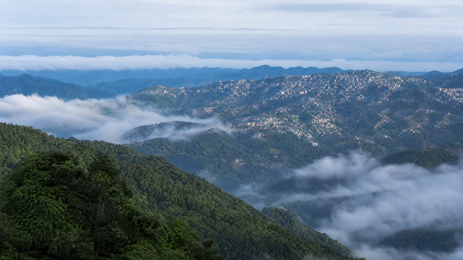
Mizoram is a time-intensive hill state at India’s southeastern edge, where roads follow ridges, bamboo-rich forest meets protected highlands, and valleys hold small settlements. Aizawl is the practical base and clearest urban window on contemporary Mizo life; the east and south reward slower travel with Champhai’s cultivated valley, Vangchhia’s carved stones, Blue Mountain country and Palak Lake. The west offers rainforest-scale Dampa, while Hmuifang, Reiek, Tam Dil and Vantawng are strong extensions from the capital. Long overland days, rain-sensitive roads and conservation rules make this a place to explore by clusters, not checklists. Give village, church and forest settings the quiet consideration expected of a guest. Its rewards are unhurried ridge views, attentive cultural landscapes, and a grounded sense of the forests and communities that shape the state. Plan for two or three compatible clusters, retain weather buffers, and confirm changing access before departure.
Regional notebook
Begin with the shape of the region.
Mizoram is best read as a set of hill-worlds rather than a single scenic drive. Aizawl has the greatest concentration of services, museums and onward transport, yet even its neighbourhoods climb narrow ridges. Shorter excursions reveal old-chief landscapes at Falkawn, high forest at Hmuifang and Reiek, and Tam Dil’s wooded water. Longer arcs lead east to Champhai and Vangchhia, west to Dampa’s lowland rainforest, or south to Phawngpui’s exposed ridges and Palak’s low wetland. Remote places deepen the ecological and cultural picture but consume more daylight and need flexibility. Build around two or three compatible clusters, not a sequence of day trips. This is a curated introduction, not a literal inventory of every significant place.
Landscape
Geography changes the journey.
Mizoram lies in southern Northeast India, bordered by Myanmar to the east and south and Bangladesh to the west. Its roughly 21,000 square kilometres are intensely folded: steep parallel hills, deep river gorges and narrow ridge settlements dominate the view. Many hills sit near 1,000 metres, while Phawngpui reaches 2,157 metres. Rivers drain north or south through valleys, and bamboo, mixed forest, cultivated slopes and village land uses meet closely. This topography makes distance deceptive: a short-looking route can involve many bends, steep gradients and weather-sensitive sections. Lowland forest in the west and south feels warmer and more humid; Champhai and Phawngpui can feel markedly cooler.
Living culture
Arrive as a guest, not an audience.
Mizo is the shared everyday language for much of the state, with English widely useful in administration and education; Lai, Mara, Hmar, Chakma and other communities add to its cultural range. Christianity shapes the public rhythm of towns and villages, while older social memory remains legible in the Zawlbuk dormitory, chief’s house, memorial stones, oral histories and agricultural festivals. Tlawmngaihna, often explained as an expectation of selfless hospitality and service, is a useful visitor principle: accept welcome without presuming on it, ask before photographing people or homes, and keep noise low near worship and residential settings. Chapchar Kut is a spring-time cultural focal point linked historically to the pause after clearing jhum fields; dates and public access require local confirmation.
Curated regional atlas
Places that reveal different parts of Mizoram
This is a selective, geographically varied starting point rather than an exhaustive list. Use it to choose a coherent route, not to compress every place into one trip.
Hill capital city · Aizawl District
Aizawl
Aizawl is Mizoram’s capital, administrative centre and most workable first base, spread across steep ridges above the Tlawng and Tuirial valleys. At roughly 1,132 metres, it combines a dense hillside townscape with far views of layered green slopes. Its modern role sits alongside a history shaped by nineteenth-century colonial settlement and Mizo leadership. The city is the easiest place to understand daily rhythms, find the state museum and organise onward travel, but it is not a flat, walkable capital: lanes, stairways and traffic on ridgelines set the pace.
Why this place matters
Choose Aizawl for the strongest introduction to contemporary Mizo civic and cultural life before heading into less serviced districts. It makes sense for travellers who value museums, neighbourhood views, church-dominated skylines and practical trip preparation as much as wilderness. The city also gives a useful contrast to the smaller villages and protected landscapes elsewhere in the state: one sees how steep topography shapes housing, commuting and public space. Two unhurried nights make room for cultural context, recovery from arrival and a flexible weather buffer.
Cultural village and open-air interpretation site · Falkawn, Aizawl District
Falkawn Zokhua
Falkawn’s Zokhua is an Art and Culture Department interpretation of a historic Lusei village on a hill south of Aizawl. Its reconstructed setting includes a chief’s house, elder’s house, blacksmith’s work area, ordinary dwelling and Zawlbuk, the bachelor’s dormitory that once had a central role in village education and social life. Memorial stones add another layer of historical memory. The value lies not in treating the site as a frozen village, but in using its buildings to understand how authority, craft, domestic work and communal training were spatially organised before modern urban life.
Why this place matters
Go to Falkawn early in a Mizoram itinerary, when its architecture and interpretation can make later villages and festivals more legible. The site gives a tangible introduction to the Zawlbuk, chief-based settlement pattern and care for socially vulnerable households discussed in Mizo history. It is especially useful for travellers who want cultural context without intruding on private village life. Pair it with Aizawl’s museum or a hillside drive, then leave time for a local conversation if interpretation is available. Avoid presenting reconstructed houses as unchanged everyday life; present-day communities are dynamic and should not be reduced to a historical display.
Forest hill and trekking landscape · Reiek, Mamit District
Reiek Hills
Reiek Hills rise west of Aizawl as a compact highland escape of forest, rock and broad ridge views. The tourism record places Reiek Tlang at about 1,208 metres, with a trail-oriented identity that contrasts with the capital’s dense ridges. The hill’s value is in its changing scale: close vegetation, limestone or rocky features, then long outlooks across a terrain of folded valleys. It is a good example of Mizoram’s accessible upland character, where a short move from the city can replace urban texture with forest and open sky.
Why this place matters
Reiek is a strong first hill outing for visitors based in Aizawl who want a landscape experience without committing to a remote multi-day circuit. It rewards an early start, a slow walk and attention to forest detail as much as the summit view. The relative proximity also makes it a sensible test of how a traveller copes with winding roads and uneven trails before choosing Hmuifang or Phawngpui. Go for a half-day or overnight pause, not as an excuse to hurry through fragile slopes.
Highland forest and village landscape · Aizawl District
Hmuifang
Hmuifang is a 1,619-metre mountain landscape about 50 kilometres south of Aizawl, known for forest that was reserved in the era of Mizo chiefs, open summit grassland and views over surrounding hills. It is not solely a lookout: nearby hillside villages and the mountain’s former chief-linked land give the place a cultural frame. The forest supports orchids and birdlife, while grass patches and cliffs make the weather visible in a different way than in Aizawl. Hmuifang offers a gentler highland contrast to the more distant Blue Mountain, with an emphasis on slow observation rather than difficult wilderness travel.
Why this place matters
Go to Hmuifang for a day or overnight when you want highland forest, village geography and a cooler setting without a long cross-state transfer. It is especially useful for travellers combining cultural interest with easy nature time: the summit, grassland and surrounding settlements allow discussion of chief-era land, rural livelihoods and local seasonal events without assuming access to private life. The mountain is appealing in clear weather, but mist can be part of the experience rather than a failure. Choose it over a rushed waterfall detour if your priority is walking, birds and a sense of elevation.
Forest lake and recreational landscape · Near Saitual, Saitual District
Tam Dil
Tam Dil, literally the Lake of Mustard, sits near Saitual in a wooded basin and is one of Mizoram’s most visited lakes. It is associated with a well-known local origin story centred on a mustard plant and a flooded valley, while its contemporary setting includes fisheries development and a tourism-oriented lakeside environment. Thick forest around the water supports a quieter, enclosed landscape than the state’s exposed ridges and waterfalls. Tam Dil is not a remote wetland expedition; it works as a restorative water-and-forest stop from Aizawl, provided visitors approach it as a living managed landscape rather than an empty picnic ground.
Why this place matters
Choose Tam Dil when a short itinerary needs a lake setting, local folklore and an easier nature pause. Its proximity to the capital makes it suitable for families, slower walkers and travellers who do not want a demanding summit day. The lake offers a useful counterpoint to river gorges and waterfalls: still water, forest edge and a story tied to cultivation show another relationship between landscape and memory. It is also a practical weather alternative if high viewpoints are clouded in.
Waterfall viewpoint · Near Thenzawl, Serchhip District
Vantawng Falls
Vantawng Khawhthla is Mizoram’s highest waterfall, dropping through forested, steep-sided terrain on the Vanva River near Thenzawl. Official district material records the fall at about 750 feet and notes that the surrounding hillsides make close approach difficult; the intended experience is a secure distant viewpoint rather than immersion at the base. The name carries a local story of Vantawnga, remembered as an exceptional swimmer. In the broader landscape, the fall demonstrates why Mizoram’s rivers produce dramatic cascades: water gathers on high, rain-fed hills and descends rapidly through narrow valleys.
Why this place matters
Vantawng is the right choice for travellers who want one decisive waterfall view within a central Mizoram circuit. The viewing-tower approach makes it more realistic than trying to reach a dangerous river edge, and Thenzawl offers a useful point in an Aizawl–Hmuifang–Serchhip route. The site is most rewarding when treated as a landscape observation: forested slopes, high rainfall and the distant sound of the river matter as much as the photograph. It is less suitable for visitors expecting swimming or unrestricted access.
Tiger reserve and rainforest landscape · Mamit District
Dampa Tiger Reserve
Dampa Tiger Reserve occupies Mizoram’s northwest, a large forested landscape near the Bangladesh and Tripura side of the state. The forest department describes a 500-square-kilometre core and 488-square-kilometre buffer, stretching from about 200 to 1,200 metres and receiving 2,000–2,500 millimetres of rain annually. Its moist forest mosaic supports elephant, gaur, leopard, wild dog, primates, hornbills and many less visible species. That list should create humility, not an expectation of sightings: Dampa is habitat first, not a wildlife display.
Why this place matters
Choose Dampa for forest depth and birdlife rather than for a guaranteed encounter with a named animal. It is among the state’s most consequential conservation landscapes and offers a clear contrast to the high ridges of Phawngpui or the cultivated Champhai area. Serious nature travellers should allow time, keep expectations quiet and value tracks, canopy, calls and habitat patterns even when wildlife remains unseen. The reserve is a substantial detour from Aizawl, so it fits a dedicated westward leg rather than a compressed general tour.
Upland borderland town and cultivated valley · Champhai District
Champhai
Champhai is an eastern hill town at about 1,331 metres, surrounded by rolling slopes and a notably open cultivated valley. It provides a valuable visual change from Aizawl’s compact ridges: agricultural fields and distant hills make the relationship among town, cultivation and frontier geography easier to read. The official tourism profile places it roughly 188 kilometres from Aizawl, a reminder that a map’s short span is a long road day in Mizoram. Champhai is a practical eastern base for Vangchhia and Murlen, while its upland climate can feel cool in winter.
Why this place matters
Choose Champhai to slow down in eastern Mizoram and see a more open agricultural landscape before moving toward archaeology or forest. It offers a sensible overnight break on a route that would otherwise become an exhausting drive from the capital. Travellers interested in food systems, valley geography, ridge settlement and borderland history will find more to observe here than at a single scenic stop. Its value is strongest when combined with Vangchhia’s carved stones and Murlen’s forest, creating a coherent eastern circuit.
Archaeological landscape · Vangchhia, Champhai District
Vangchhia Menhirs and Caves
Vangchhia is Mizoram’s principal protected archaeological landscape, a hill site near Khawbung where the Archaeological Survey of India records almost 180 menhirs. The carved stones bear human figures, mithun heads, deer, weapons and circular motifs; local tradition understands many as memorials to heroes and their achievements. The site also includes a weathered rock shelter, post-hole traces, handmade pottery and old stone-paved routes toward the Tiau River. These elements make Vangchhia more than a row of stones: it is evidence of commemoration, movement, subsistence and settlement in a borderland hill setting.
Why this place matters
Go to Vangchhia for a rare archaeological counterweight to Mizoram’s dominant nature imagery. The site connects Mizo oral memory, monumental carving and material traces without requiring visitors to force a single definitive interpretation onto the past. It rewards a guided or well-explained visit, careful looking at motifs and time to understand the wider slope and river-route setting. Pair it with Champhai rather than attempting it as a hurried capital day trip. Heritage-minded visitors should be prepared for uneven ground and changeable logistics, but the reward is a deeper sense that Mizoram’s cultural landscapes extend well beyond nineteenth- and twentieth-century history.
National park and birding forest · Champhai District
Murlen National Park
Murlen National Park is a 100-square-kilometre protected forest in eastern Mizoram, reached through the Champhai side and spanning roughly 400 to 1,900 metres. Its subtropical evergreen and sub-montane forest supports Mrs. Hume’s pheasant, kaleej pheasant, hornbills, owls, serpent eagle, serow, barking deer and arboreal mammals. Rocky cliffs with swifts and swallows add a vertical dimension to the forest. Murlen’s significance lies in habitat continuity and quiet bird observation, not speed or spectacle. The official travel window runs from October to May, yet the park’s remoteness and forest weather mean that every visit needs current local confirmation and a willingness to accept limited visibility or wildlife encounters.
Why this place matters
Murlen is the eastern choice for travellers who would rather listen and look closely than chase dramatic summits. Its varied elevation and forest types give birders and naturalists a distinct counterpart to Dampa’s lower, wetter rainforest and Phawngpui’s exposed montane ridges. The chance to encounter the state bird’s habitat, rather than a certainty of seeing it, is the appropriate reason to go. Build it into a Champhai-based circuit, allow two nights in the wider area and keep the schedule loose enough for weather.
High mountain national park · Lawngtlai District
Phawngpui National Park
Phawngpui, the Blue Mountain, is Mizoram’s highest peak at 2,157 metres and the centre of a 50-square-kilometre national park in the far south. A ridge running roughly north–south rises above sheer cliffs and looks toward the Chhimtuipui River bend and Myanmar hill ranges. The park holds oak, rhododendron, bamboo, grassy glades and orchids alongside goral, serow, primates and a remarkable bird assemblage including Blyth’s tragopan and Mrs. Hume’s pheasant. Temperatures can range widely, with official material citing roughly 2–30°C.
Why this place matters
Go to Phawngpui for Mizoram’s clearest high-ridge experience: cliffs, flowering vegetation, distant blue hill layers and habitat changes that are difficult to see elsewhere in the state. It earns a place on a longer southern itinerary, not on a rushed plan. The reward is as much the approach through remote country as the summit landscape, which makes the journey suitable for patient walkers and nature-focused travellers. Choose Dampa instead if lowland rainforest is the priority, or Hmuifang if time is tight.
Protected wetland and forest lake · Near Phura, Siaha District
Palak Wetland
Palak Dil, also called Pala Tipo, is Mizoram’s largest natural lake and the core water body of a protected wetland near Phura in the south. The forest department places it within the Indo-Burma biodiversity hotspot, about 274 metres above sea level, with an 18.5-square-kilometre wetland reserve and a lake area of roughly 1.5 square kilometres. Tropical evergreen and semi-evergreen forest, marshy ground and bamboo surround the lake. Surveys cited by the department record rich bird, mammal, amphibian and reptile diversity, including primates and wetland birds.
Why this place matters
Choose Palak for a slower southern wetland experience that differs sharply from ridge hiking. The lake’s low elevation, marsh and forest edge give birders and attentive travellers a different set of sounds, light and habitats from Phawngpui’s exposed heights. It is best approached as a conservation landscape with a living Mara cultural context, not as a generic boating stop. The remoteness is part of its value and its challenge: the approach from Phura has historically involved light-vehicle limitations, so realistic routing matters.
Season and pace
Choose a date window for the experience, then keep a fallback.
Rainfall shapes travel more than a sharp temperature divide. Winter is generally dry, with typical state ranges around 11–21°C, while summer commonly runs around 20–29°C; altitude, cloud and time of day alter the feel quickly. Heavy monsoon rain usually arrives from May through September, supporting lush waterfalls but raising the chance of landslides, blocked roads, poor visibility and disrupted plans. October through March usually gives the best balance for road travel, viewpoints and protected areas. Water levels and access at wetlands, waterfalls and rivers change with the season; current conditions always matter more than a photograph.
Movement and planning
Distance on a map is not the same as usable travel time.
Moving through the region
Aizawl is the operational hub, reached through Lengpui Airport and long road approaches from neighbouring rail and road gateways. Hill driving is slow by design: use daylight, allow for roadwork or rain delays, and do not schedule a major hike immediately after a long transfer. Slopes, stairs and irregular pavements can be demanding within Aizawl; remote viewpoints, forest paths and waterfall overlooks are often unsuitable for wheelchairs or anyone needing step-free access. A hill-experienced vehicle and driver reduce fatigue but not weather uncertainty. Confirm road status, park opening and local restrictions through the relevant official or local channel shortly before departure.
Building a workable route
Begin with entry formalities. Indian visitors commonly need an Inner Line Permit, and foreign visitors have separate registration or entry requirements; verify rules, validity and arrival procedures through the relevant official channel before committing to transport. Carry identity documents, rain protection, a warm highland layer, sturdy shoes, medicines and offline maps. Keep the circuit compact: Aizawl–Hmuifang–Thenzawl suits a first visit; Champhai–Vangchhia–Murlen needs more road time; Phawngpui and Palak are separate southern commitments. Protected areas may require permission, local guidance or limited entry windows. Confirm permits, trail condition, accommodation, network coverage, fuel and weather locally.
Travel responsibly
The regional context includes its limits.
Mizoram’s appeal depends on living villages, forest edges and fragile slopes remaining liveable. Carry out all packaging, use refillable water containers where safe, and avoid single-use litter at lakes, roadsides and viewpoints. Stay on permitted paths; do not enter closed forest, cliff or border-adjacent areas, and do not chase, feed or call wildlife. Waterfalls and wet rocks deserve distance rather than staged photographs. At Vangchhia and other heritage places, do not touch, climb or rub carvings. Ask before photographing people, worship spaces, ceremonies, homes or craft work. Dress and conduct should be considerate in villages and church-oriented settings. If authorities issue rain, road or wildlife advisories, revise the plan rather than trying to bypass them.
This is an evergreen regional guide. Weather, permits, closures, transport and local rules can change; confirm material conditions through the relevant local or official channel before travel.