Northeast India · State · ML
Meghalaya
Meghalaya is a high-rainfall hill state in Northeast India where weather and community stewardship shape travel as much as distance. Shillong is the urban base; the Khasi Hills hold Sohra’s escarpments, root-bridge valleys and sacred groves; the Jaintia Hills combine rivers, falls and megaliths; and the Garo Hills reward longer journeys with forests, caves and protected landscapes. A short road can be slowed by cloud, wet surfaces or a long descent, while a village landscape may be culturally significant as well as beautiful. Plan one hill circuit at a time, use local knowledge where terrain calls for it, and accept that rain, river levels and conservation controls can change the day. Shillong is the administrative capital.
Regional notebook
Begin with the shape of the region.
Meghalaya’s waterfalls, rivers, caves and root bridges belong to very different terrains and community settings. Shillong and nearby Khasi Hills suit a first route of short drives and cultural stops. Sohra, Nongriat and Mawsynram are more weather-exposed and can mean steps, wet ground or guide-dependent natural sites. West Jaintia Hills adds river country, waterfalls and Nartiang’s ancestral stones. The Garo Hills require more travel time but bring forests, caves, plateaus and Garo cultural context. This record selects signature places rather than a complete inventory. Choose between a compact Shillong–Sohra–Jaintia circuit and a longer Garo Hills itinerary; in either, weather, water and protected-area controls are operational facts.
Landscape
Geography changes the journey.
Meghalaya is a plateau and hill system south of the Brahmaputra valley, bounded by Assam to the north and east and Bangladesh to the south and west. Moist monsoon air meets steep southern escarpments, producing the extraordinary falls, caves and river landscapes around Sohra and Mawsynram. Shillong and much of the Khasi–Jaintia plateau are altitude-moderated; the Garo Hills descend toward warmer, humid lowlands. Limestone and sandstone create caves, ravines and fossil-bearing strata, but also demand care on wet, unstable or poorly lit ground.
Living culture
Arrive as a guest, not an audience.
Khasi, Pnar or Jaintia, and Garo communities shape Meghalaya’s cultural geography and land relationships. Matrilineal traditions are important in several communities, but everyday norms remain local and varied. Root bridges are long-term Khasi landscape engineering; Mawphlang’s sacred grove is protected through customary belief. Nartiang’s stones make Jaintia ancestral commemoration visible, while Garo forest, jhum cultivation histories, oral traditions and Balpakram are closely interwoven. Festivals belong to living community calendars, not fixed entertainment. English is useful in formal travel settings; ask before photographing people or rituals and accept community guidance.
Curated regional atlas
Places that reveal different parts of Meghalaya
This is a selective, geographically varied starting point rather than an exhaustive list. Use it to choose a coherent route, not to compress every place into one trip.
capital city and hill station · East Khasi Hills
Shillong
Shillong is Meghalaya’s administrative capital and the operational gateway to the Khasi and Jaintia Hills. Set at roughly 1,496 metres, it has a cooler highland feel than the lower Garo country and compresses markets, institutions, music culture, churches, lakeside walks and short excursions into one urban base. Its real value in an itinerary is logistical as well as atmospheric: it is where travellers can pause after a long arrival, adjust to wet-weather conditions, arrange onward transport and understand the state before heading into more remote valleys.
Why this place matters
Choose Shillong for an entry point with cultural texture rather than solely as a transit city. It provides the most practical balance of accommodation choice, food, urban services and access to the southern escarpment, Mawphlang, Mawsynram and Jaintia roads. The city also helps reveal a contemporary side of Meghalaya that waterfall itineraries can miss: Khasi life, local music traditions and civic institutions sit alongside the hill-station legacy. It is especially useful for travellers who prefer short, flexible day excursions before committing to a demanding walk or a long Garo Hills transfer.
rainfall plateau and escarpment town · East Khasi Hills
Sohra (Cherrapunji)
Sohra, also called Cherrapunji, sits on the southern Khasi Hills escarpment where rainfall, limestone and steep relief have produced a concentrated landscape of falls, caves, gorges and cloud-wrapped viewpoints. It is about 55 kilometres by road from Shillong, but weather and road conditions matter more than a simple distance estimate. Nohkalikai, Nohsngithiang, Mawsmai and Arwah are part of the wider Sohra circuit, while the road onward leads toward Tyrna and Nongriat. The town is a sensible base for reading the region’s rain-shaped geology rather than trying to treat each natural feature as isolated.
Why this place matters
Sohra is the strongest choice for travellers seeking the visual logic of Meghalaya: rain striking a plateau, water dropping toward Bangladesh-facing lowlands, and caves formed in a porous limestone landscape. It offers a wide range of experiences without requiring a remote expedition, from roadside viewpoints to guided cave visits and valley descents. The trade-off is exposure. Dry-season clarity can support views and walks, while the rains deliver fuller waterfalls and mist but make plans less predictable. Allow time to respond to conditions rather than expecting every viewpoint to perform the same way.
living cultural landscape and trekking village · Nongriat, East Khasi Hills
Nongriat Living Root Bridges
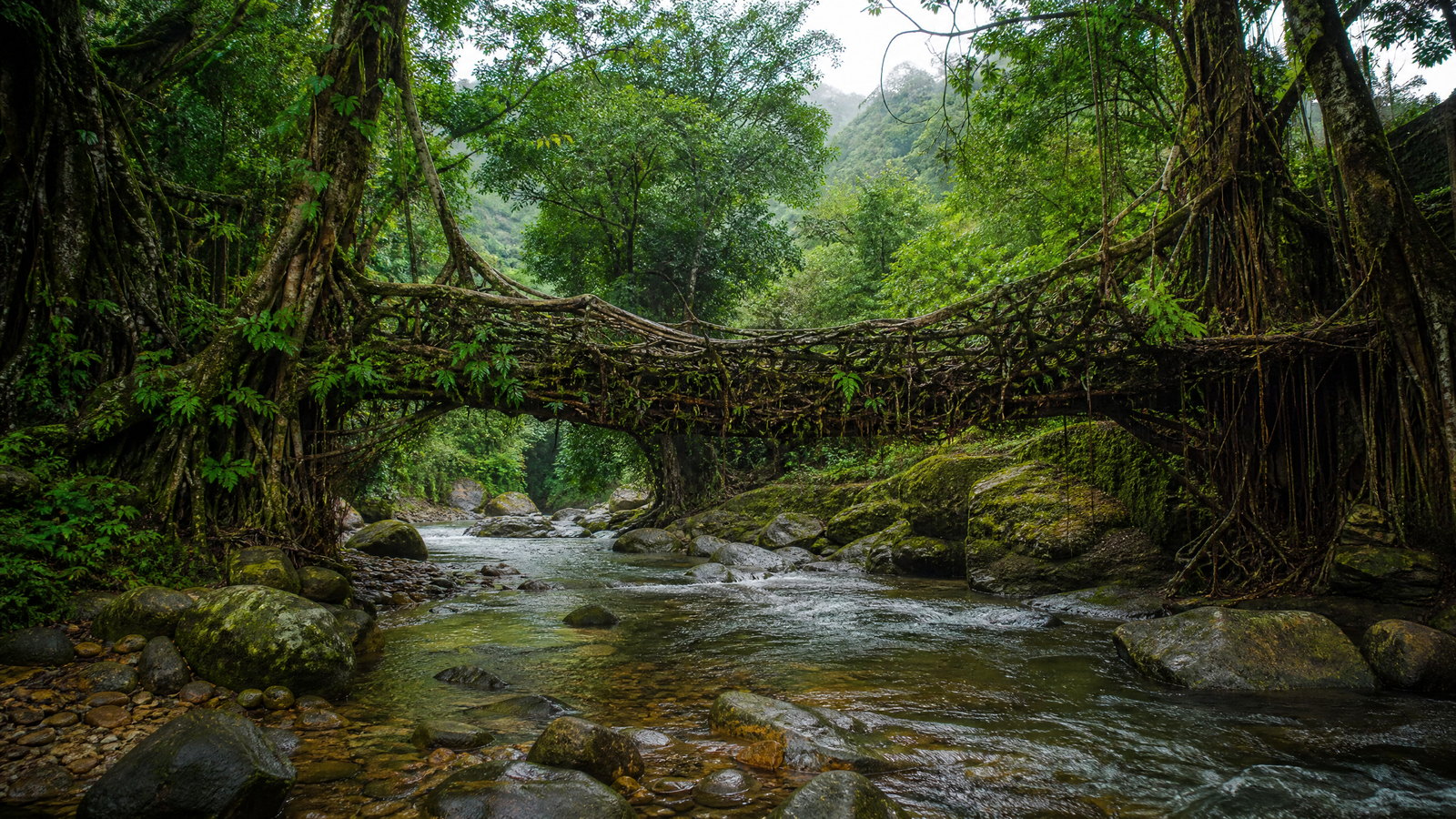
Nongriat is a forested Khasi village below the Sohra plateau, known for the Double Decker Living Root Bridge grown from the guided roots of rubber fig trees. Reaching it usually begins with a road transfer to Tyrna and a descent of roughly 3,000 to 3,500 stone steps through a humid valley. The bridge is the result of generations of practical ecological engineering: roots are trained across watercourses and strengthen as living structures over time. Smaller root bridges, pools and waterfalls belong to the same landscape, but the village should not be reduced to one photo stop.
Why this place matters
Go to understand an extraordinary form of community knowledge that joins botany, infrastructure and terrain. The bridge is powerful precisely because it is alive and functional, set in a valley where ordinary movement has long required resilient crossings. The journey also shows the contrast between the open Sohra plateau and a deeply vegetated southern-range valley. It is rewarding for fit walkers willing to give the place an overnight or an unhurried day. It is a poor match for anyone unable to manage a long stair descent and strenuous uphill return, especially in humid or wet conditions.
sacred forest and cultural landscape · Mawphlang, East Khasi Hills
Mawphlang Sacred Grove
Mawphlang’s sacred grove, known locally as a law kyntang, is an old-growth forest sustained by Khasi customary protection rather than a conventional recreational park. About 25 kilometres southwest of Shillong, the grove stands in marked contrast to the open meadows and pines of the surrounding highland. Its dense canopy, humid floor, epiphytes and decomposing wood demonstrate the ecological consequence of long-term restraint. The place also carries spiritual significance: visitors are not permitted to remove anything, including a pebble, leaf or twig.
Why this place matters
Mawphlang offers a deeper encounter with Meghalaya’s relationship between belief and biodiversity than a standard forest walk. It is particularly valuable alongside the root bridges: both are enduring examples of cultural practice shaping ecological outcomes, though one creates living crossings and the other preserves a forest. Its proximity to Shillong makes it accessible for travellers with limited time, while its meaning rewards a slow visit with local interpretation. The main trade-off is that respectful access matters more than freedom to wander; visitors should accept the grove’s customary boundaries without testing them.
rainfall landscape and geological countryside · East Khasi Hills
Mawsynram and Mawlyngbna
Mawsynram, around 61 kilometres south of Shillong, is associated with exceptionally high annual rainfall and gives a more rural, geological counterpart to Sohra. The wider plateau includes rain-fed ravines, caves, rock formations, pools and the fossil-rich landscape around Mawlyngbna. Its sandstone and limestone features make clear that Meghalaya’s drama is not confined to waterfalls: exposed strata, crevices and ancient marine traces point to a much longer environmental history. The journey is best understood as a countryside circuit, not a single attraction.
Why this place matters
Choose Mawsynram for a landscape-first understanding of why the southern Khasi Hills feel so distinct. It complements Sohra rather than replacing it: Sohra concentrates famous escarpment views, whereas Mawsynram offers a more dispersed mix of rain, geology and village country. Travellers interested in caves, fossils and short guided walks will find more decision value here than those seeking an urban base. The central trade-off is weather. The monsoon gives the fullest expression of the terrain but can restrict safe movement; post-monsoon conditions often make geological features and walks easier to appreciate.
Khasi village and living cultural landscape · East Khasi Hills
Mawlynnong
Mawlynnong is a Khasi village in the southern ranges, approached from the Shillong side through Pynursla country. It is widely recognised for collective cleanliness practices, gardens, streams and an enduring relationship between settlement and lush subtropical vegetation. The Nohwet Living Root Bridge nearby shows the same slow, intergenerational root-training tradition seen elsewhere in the state, while the century-old Church of the Epiphany and views toward the Bangladesh plains add built and geographic layers. Mawlynnong is not an untouched wilderness; its appeal is a maintained village landscape whose order depends on resident practice.
Why this place matters
Mawlynnong is a good choice for travellers wanting to see how daily care, Khasi traditions and a rain-fed landscape meet at village scale. It pairs naturally with Dawki and Shnongpdeng but has a different tone: gardens, lanes and root-bridge craft rather than river recreation. The place is especially meaningful for travellers interested in community-led environmental practice and in the subtropical transition toward the Bangladesh-facing plains. Visit outside the pressure of a rushed day loop if possible; its strongest experience is observing a lived-in landscape respectfully, not chasing a title or judging residents’ routines.
borderland river landscape · West Jaintia Hills
Dawki–Shnongpdeng and the Umngot River
Dawki is a West Jaintia Hills border town on the Umngot River, with Shnongpdeng and Darang forming a riverside landscape downstream and nearby. In the drier season, the river is noted for its clarity, pale stone bed and calm-looking reaches, while the suspension bridge and views toward Bangladesh place it within a working borderland rather than an isolated leisure site. River conditions change with rainfall, sediment and releases upstream, so photographs do not define water safety or visibility. The locality is reached by hill roads from Shillong or Jowai and is best approached with time for the winding transfer, not as a guaranteed short stop.
Why this place matters
This is Meghalaya’s clearest contrast to the clouded plateau: a river valley where the hills open toward the plains of Bangladesh. It suits travellers looking for a low-elevation landscape, boat-based observation where currently permitted, and a base for understanding the Jaintia Hills’ southern edge. Pair it with Nartiang or Krangshuri for a richer regional arc of memory, water and limestone. The trade-off is seasonality and safety. Clear-water conditions are often associated with drier months, while monsoon flow and visibility can alter both the experience and what activities are allowed.
megalithic heritage landscape · Nartiang, West Jaintia Hills
Nartiang Megaliths
Nartiang is a quiet West Jaintia Hills village with one of Northeast India’s most substantial concentrations of monoliths. Standing menhirs, called moo shynrang, and flat dolmens, called moo kynthai, form a landscape of ancestral memory associated with the former Jaintia kingdom. Some stones are linked to royal and noble commemoration, with the site’s principal phase extending over centuries and additions continuing into the nineteenth century. The arrangement matters as much as the scale: it expresses gendered ancestral reference, ritual and political history in an open village setting.
Why this place matters
Visit Nartiang to add historical depth to an itinerary otherwise dominated by water and forest. The stones make visible that Meghalaya’s heritage is not only colonial or natural; long-lived indigenous political and ritual traditions are inscribed in the terrain. The site works well at an unhurried pace, ideally with contextual explanation, and can be combined with Jowai or Krangshuri without forcing a long return to Shillong. Its trade-off is subtlety: travellers seeking a heavily curated monument may find a village heritage setting quieter than expected, whereas those open to landscape-based history will gain more.
waterfall and forest pool · Near Amlarem, West Jaintia Hills
Krangshuri Falls
Krangshuri Falls is a broad curtain of water dropping from a forest stream over a rocky ledge near Amlarem in West Jaintia Hills. The pool below can appear vivid blue in clearer, drier conditions, but its colour should not be confused with predictable depth or safety. Reaching the lower view involves a descent through greenery from the approach area, making wet footwear and return effort relevant. The falls are roughly a short drive from Jowai’s wider road network and pair well with Nartiang or Dawki.
Why this place matters
Krangshuri is an effective choice for travellers who want a waterfall experience within a West Jaintia Hills route rather than a repeat of the Sohra circuit. Its setting demonstrates how local geology and forest cover create a different scale of water landscape. The journey can be combined with heritage at Nartiang or riverside Dawki, giving one day genuine thematic variety. The decisive trade-off is water risk. Drier months may make the pool visually clearer, but conditions, entry rules and currents can change; view the falls as a landscape first, and use water only when current local guidance permits.
forest peak and town overlook · Near Tura, West Garo Hills
Tura Peak
Tura Peak rises close to Tura town in the West Garo Hills and provides a forested, relatively accessible introduction to the Garo Hills conservation landscape. The summit is near 900 metres and is reached by a moderate walk, commonly beginning near Akonngre; a return outing can take around one to one and a half hours depending on conditions and pace. The route passes through reserve-forest habitat where birds and primates may be present, though wildlife is never assured. From clear viewpoints, the outlook extends across Garo hill country and toward the plains.
Why this place matters
Tura Peak is the practical first nature stop for a Garo Hills itinerary. It asks far less of a traveller than Nokrek, Balpakram or Siju while still offering a sense of forest, elevation and the region’s broad horizon. The setting makes it especially useful after a long road arrival in Tura, or before deciding whether to invest several more days in protected-area country. Its reward depends on weather: clear panoramas are more likely in the drier months, while rain can make trails slick and close views into mist. Treat it as a forest walk, not a guaranteed wildlife encounter.
biosphere reserve and national park · Tura Range, Garo Hills
Nokrek Biosphere Reserve and National Park
Nokrek is a mountainous biosphere reserve on the Tura Range, recognised internationally within the Man and the Biosphere Programme and centred on a national park. The broader reserve holds evergreen and semi-evergreen forest, perennial river catchments and the wild citrus resource for which the area is especially important. Nokrek Peak reaches about 1,412 metres, while the reserve’s terrain changes from gentler northern hills to steeper southern slopes. Elephants, hoolock gibbons, slow lorises and other threatened wildlife occur in the wider landscape, but their presence is a conservation fact, not a viewing schedule.
Why this place matters
Nokrek is for travellers who want to exchange easy sightseeing for ecological depth. It offers a way to understand the Garo Hills as a connected catchment and forest system, including the conservation of wild citrus, rather than as a collection of scenic stops. The reserve also gives cultural context to Garo hill communities and their relationship with land. It needs time, patience and a willingness to follow forest-management advice. Visibility, entry arrangements and trail condition can vary; a visit is most rewarding when framed around habitat, plants and landscape process rather than hoping to encounter a particular animal.
national park, plateau and gorge landscape · South Garo Hills
Balpakram National Park
Balpakram National Park occupies a remote South Garo Hills landscape of plateaus, deep gorges, limestone formations, grassland and dense forest. It lies within a larger Garo Hills conservation mosaic that connects national parks, a wildlife sanctuary, reserve forests and community-owned forest. The park’s dramatic relief is tied to Garo cultural memory: the plateau and gorges hold traditions concerning spirits and ancestors, giving its scenery a meaning beyond geology. Wildlife habitat includes elephants, primates, carnivores and rich birdlife, but the park is not a zoo and sightings cannot be forecast.
Why this place matters
Balpakram is the choice for a longer, more immersive Garo Hills journey where natural history, cultural landscape and remoteness are inseparable. Its gorge-and-plateau form differs dramatically from Sohra’s rain escarpment, while the surrounding protected mosaic explains why this area matters for connectivity as well as scenery. It is suited to travellers prepared for slow overland travel, simple logistics and changing park protocols. It is not a casual add-on from Shillong. Give it dedicated days and treat current forest guidance as decisive, particularly in wet weather, when road condition and access may change rapidly.
limestone cave and river-valley habitat · South Garo Hills
Siju Cave and the Simsang Valley
Siju Cave, also known as Dobakkol or Bat Cave, is a long limestone cave system in South Garo Hills near the Simsang River and Siju Wildlife Sanctuary. Stalactites, stalagmites, underground water and bat habitat make it a significant speleological landscape, while the surrounding valley belongs to the wider Garo Hills conservation setting. Its recorded passages extend for several kilometres, but this does not mean all areas are appropriate for general visitors. Cave environments are dark, wet, disorienting and ecologically sensitive; bats and specialised cave species depend on low disturbance.
Why this place matters
Siju offers the underground counterpart to Meghalaya’s rain and forest landscapes. It is compelling for travellers interested in limestone process, cave ecology and the close relationship between a river valley and subterranean habitat. Pairing it with Balpakram can deepen a South Garo Hills route, though the two should not be compressed into an unrealistic day. The trade-off is access complexity: light, footing, water levels, bat welfare and permissions matter more than cave length. A responsible visit accepts only the currently approved portion and values expert local guidance over independent exploration.
Season and pace
Choose a date window for the experience, then keep a fallback.
October through April is broadly easier for road travel, walking and clearer river views, though showers and cool evenings remain possible. March to May can be warmer in lower Garo areas. June to September brings full waterfalls and mist but also a higher likelihood of landslides, slippery steps, rough approaches, swollen streams and curtailed outdoor activity. Shillong and Jowai are cooler than lower Garo hills, yet temperature varies with altitude and cloud. Check current district weather and hazard notices before waterfall, cave, valley-walk or long-drive plans; no seasonal label guarantees access.
Movement and planning
Distance on a map is not the same as usable travel time.
Moving through the region
Road travel links most destinations. Shillong is the practical Khasi–Jaintia hub; Tura and Baghmara anchor the Garo circuit. Air and rail gateways may be outside the state or operate on limited schedules, so allow for meaningful road transfers. Shared vehicles connect some towns but can thin later in the day. A dedicated vehicle or skilled local driver helps on dispersed Garo routes, Dawki’s river villages and rainy roads. Winding, wet or rough surfaces make times variable. Some destinations add a stair descent or forest walk after the road ends, so plan for daylight, return effort and physical access.
Building a workable route
For a first week, base near Shillong and group Sohra, Nongriat, Mawphlang, Mawsynram and Jaintia sites by direction. Add Garo Hills only with extra nights: Tura, Nokrek, Balpakram and Siju are not a practical extension of a rushed Shillong circuit. Carry rain protection, non-slip footwear, a warm layer, water and a light for any approved cave visit. Nongriat requires a demanding stair descent and return ascent. Caves, protected areas, boats and swimming zones can have changing rules or closures. Confirm road status, transport and access through the relevant local or official channel shortly before travel.
Travel responsibly
The regional context includes its limits.
Treat photogenic sites as living cultural and ecological landscapes. On root bridges, follow local instructions and never pull, carve, climb on or remove living material. In sacred groves, taking even small natural objects breaches the place’s meaning. In caves, avoid disturbing bats and enter only approved passages. Water clarity does not establish depth, current or swimming safety; heed closures and use approved access. Keep wildlife viewing quiet and distant, minimise litter and never cross a border informally. Heavy rain can transform streams, slopes and roads, so turn back when authorities, guides or residents advise it.
This is an evergreen regional guide. Weather, permits, closures, transport and local rules can change; confirm material conditions through the relevant local or official channel before travel.