Northeast India · State · MN
Manipur
Manipur is a highland-and-valley state in India’s northeast, organised around the Imphal valley and ringed by forested hills. Its strongest journeys pair the capital’s layered civic and royal heritage with the living wetland of Loktak, then add one hill district rather than rushing across the map. Imphal offers Kangla, the women-run Ima Keithel and Vaishnavite ritual space; Bishnupur adds Moirang’s independence-era memory and the phumdi landscape that sustains the Sangai. Eastward, Ukhrul brings Tangkhul cultural landscapes, a seasonal endemic lily, caves and black pottery; western routes lead to caves, lakes, meadows and rivers around Tamenglong. The trade-off is time: roads cross steep, rain-sensitive terrain and local conditions can alter plans. Give priority to verified access, community consent and an unhurried pace. Manipur rewards travellers who treat its diverse communities, sacred places and fragile habitats as living places rather than backdrops.
Regional notebook
Begin with the shape of the region.
Manipur joins a central valley to forested hill districts. Base in Imphal, then give Loktak–Moirang a full day. Add either Ukhrul–Senapati or Tamenglong, unless time permits both. These 13 signatures are selective, not exhaustive.
Landscape
Geography changes the journey.
The state has a relatively level inner valley and rugged outer hills. Imphal lies near 790 metres; elevation runs from low Jiribam to high Mount Iso. Loktak anchors the central plain. Hill transfers take longer than map distance suggests. Valley vehicle approaches suit visitors with limited mobility; caves, ridges and waterfalls commonly involve steps, mud or uneven ground.
Living culture
Arrive as a guest, not an audience.
Meitei institutions are prominent in the valley, alongside Meitei Pangal and many others; hill districts include diverse Naga, Kuki-Chin and other communities. Tangkhul settings around Ukhrul do not represent all hill cultures. Meitei, English and many local languages coexist. Kangla, Ima Keithel, temples and Longpi pottery are living institutions. Ask before photography, dress modestly, and let hosts determine appropriate access.
Curated regional atlas
Places that reveal different parts of Manipur
This is a selective, geographically varied starting point rather than an exhaustive list. Use it to choose a coherent route, not to compress every place into one trip.
Historic fort and cultural landscape · Imphal, Imphal West district
Kangla Fort
Kangla is the historic seat of Manipuri power in central Imphal, occupying a landscape of moats, embankments, sacred associations and surviving structures. State tourism material identifies it as the seat of Manipur’s rulers until 1891 and an embodiment of both rulers and people. It is not simply a fort in the European sense: its value lies in the relationship between political history, ritual geography, water and memory. A visit can give essential context before seeing the wider valley, especially when paired with the State Museum or a walk through the city. Allow time to read site interpretation rather than treating Kangla as a quick photo stop.
Why this place matters
Go to understand why Imphal is more than a transport gateway. Kangla offers a concentrated introduction to Meitei historical memory, courtly heritage and the valley’s long political life, while its moats and open grounds soften the city’s pace. It is the right choice for travellers who want place-based context before moving to wetland or hill landscapes. The reward is interpretive rather than spectacular: details matter, and respectful attention makes the visit richer. It also works well for visitors who need a lower-exertion heritage stop, although surfaces, distances and access features should be checked in advance.
Living market and civic institution · Imphal, Imphal West district
Ima Keithel
Ima Keithel, often rendered as Mother’s Market, is a working Imphal market run by women vendors. State tourism describes more than 3,000 “Imas” operating stalls, with produce, fish and household groceries in one section and handlooms or household tools in another. Its significance is social and economic as much as visual: the market is a daily institution, not a staged craft precinct. It is a useful place to encounter the material culture of the valley, from food ingredients to woven goods, while observing the rhythms of an active public space. Go with time to browse slowly and without blocking vendors or customers.
Why this place matters
Choose Ima Keithel for a direct encounter with Imphal’s everyday civic life and women’s economic agency. It provides more texture than a conventional shopping stop: the arrangement of stalls, food supply and handloom trade reveal how a market can carry social history. It is particularly worthwhile for travellers interested in textiles, ingredients and small useful objects, provided purchases are made thoughtfully. The experience is busiest and most rewarding when treated as an operating workplace. Ask before taking close photographs, accept a refusal immediately, and do not assume every item is made locally.
Vaishnavite temple · Palace Compound, Imphal East district
Shree Shree Govindajee Temple
Shree Shree Govindajee Temple is a historic Vaishnavite centre in Imphal’s Palace Compound, adjacent to the former royal palace setting. The temple is known for its twin gold-sheeted domes, paved courtyard and large congregation hall; the principal Radha-Krishna image is described as carved from jackfruit wood. Daily worship and devotional activity make this an active religious place, not an architectural shell. Its setting clarifies the entwining of courtly history and Vaishnavite practice in the valley. Visit quietly, observe from permitted areas and allow the rhythm of worship to determine the experience rather than trying to impose a sightseeing schedule.
Why this place matters
Go for a focused view of living Manipuri Vaishnavite practice and temple architecture within the capital. The open courtyard, congregation space and domes make a strong visual counterpoint to Kangla’s historic landscape, yet the deeper value is the continuing devotional use. It suits travellers who want a respectful spiritual and cultural stop without a long transfer. Morning or evening worship may be meaningful for observers where attendance is permitted, but participation, dress and photography norms should follow the temple’s current rules. It is a place to listen and watch, not to interrupt rituals.
Freshwater wetland and cultural landscape · Bishnupur district
Loktak Lake
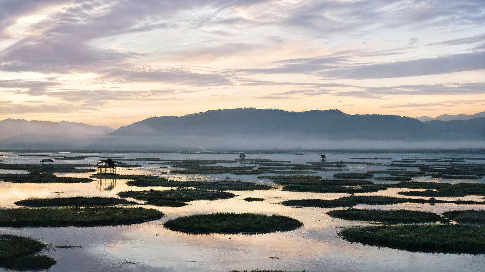
Loktak is the largest freshwater lake in Northeast India and the central valley’s defining wetland landscape. From viewpoints such as Sendra, its water, channels and phumdi mats create a shifting mosaic rather than a conventional open lake. Phumdi are floating masses of soil, vegetation and organic material; they are ecologically important and tied to lake livelihoods. State sources describe residents living on floating islands in phumsangs, while the lake authority frames Loktak as a lifeline, cultural place and fishery resource. The lake should be approached as a living, managed landscape whose beauty is inseparable from its ecological pressures and the people who depend on it.
Why this place matters
Go to see Manipur’s most distinctive inland waterscape and to understand the environmental story behind the view. Loktak rewards a slow, observant visit: light changes across the phumdi, working boats pass through channels and the hills frame the lake. It is a natural companion to Keibul Lamjao and Moirang, but it deserves its own time rather than being reduced to an overlook. Travellers interested in wetlands, livelihood landscapes and photography will find more value here than those seeking a fast recreational outing. Responsible choices matter because water quality, water levels and development pressures are active concerns.
National park and floating wetland · Loktak Lake, Bishnupur district
Keibul Lamjao National Park
Keibul Lamjao is a national park on the southern part of the Loktak wetland, defined by a continuous floating-meadow habitat. Its phumdi are not solid islands: they are buoyant, changing organic mats that support the endangered Manipur brow-antlered deer, the Sangai. The park is described by the forest department as the Sangai’s only current home, and the broader conservation area is on India’s UNESCO tentative list. Waterfowl, otters and hog deer are also part of the wetland ecology. This is a conservation visit, not a wildlife guarantee. Viewing infrastructure and staff direction exist to protect animals and the unstable habitat.
Why this place matters
Go because this is one of the world’s most unusual protected landscapes: a deer habitat formed by floating wetland biomass. The Sangai gives the park emotional resonance, but the larger lesson is the interdependence of vegetation, water regime, biodiversity and local stewardship. Patient observers can appreciate birdlife and wetland textures even without a deer sighting. The park is particularly meaningful when paired with Loktak rather than approached as an isolated animal-viewing stop. It suits travellers prepared to look from designated places, keep noise low and accept that ethical distance is part of the encounter.
Freedom-struggle memorial and museum · Moirang, Bishnupur district
Moirang INA Complex
Moirang is a town near Loktak with deep Meitei cultural associations and a major place in India’s independence-era history. State tourism records that the Indian National Army flag was first unfurled here on 14 April 1944. The INA complex and museum preserve letters, photographs, rank badges and other war memorabilia, placing the town within the Second World War and anti-colonial history of the region. Moirang is also associated with the pre-Hindu deity Thangjing and the annual Lai Haraoba ritual festival. It is therefore best read as a layered town, where museum history, ritual tradition and the lake district meet.
Why this place matters
Go to add political and cultural depth to a Loktak day. The INA collection makes Moirang an important place for travellers interested in the eastern theatre of the Second World War and India’s freedom struggle, while the town’s ritual associations resist a single narrative. This combination distinguishes Moirang from a stand-alone memorial stop. It is a good choice for visitors who value original documents and local historical context over dramatic monuments. Allow time for the museum and keep festival visits respectful: rites are community life, not scheduled entertainment for outsiders.
Highland landscape and seasonal flora habitat · Near Ukhrul town, Ukhrul district
Shirui Hills
Shirui Hills rise above the Tangkhul cultural landscape of Ukhrul. The best-known summit, Shirui Kashung, is about 2,835 metres above sea level and is associated with the endemic Shirui, or Siroy, lily. The flower, locally called Kashong Timrawon, generally blossoms on the hilltop in May and June; the peak’s slopes also feed important streams and rivers. The appeal is not only a flower season: outside bloom time the highland provides a broad hill panorama and a way to experience Ukhrul’s cooler elevation. Flowering, trail condition and access should never be assumed, especially during the wetter months.
Why this place matters
Choose Shirui for an upland contrast to the Imphal valley and for a rare plant found in a specific cultural and ecological setting. During bloom, the lily is a compelling reason to visit, but it should not turn the hill into a collection site or a crowd spectacle. At other times, the ridgeline, weather and surrounding Tangkhul landscape remain the draw. This is a good fit for travellers willing to walk at altitude and accept mist, rain or a change of plan. It pairs naturally with Ukhrul town, Longpi pottery and Khangkhui Cave.
Living craft village · Nungbi village, Ukhrul district
Longpi (Nungbi) Pottery
Longpi, also known as Nungbi, is associated with Manipur’s distinctive black earthenware, made by Tangkhul artisans without a potter’s wheel. Official district material describes a process using clay and black rock; after firing, vessels take on a dark, metal-like appearance. Cooks’ pots, water vessels, cups and other forms show that this is a practical craft as well as a visual one. The village lies on the Ukhrul–Jessami route, roughly 38 kilometres from Ukhrul town. A visit should privilege the makers’ time and working conditions rather than treat homes or workshops as open displays.
Why this place matters
Go to encounter a material tradition through the people and landscape that sustain it. Longpi pottery offers a more meaningful alternative to buying anonymous craft objects: visitors can learn why material, hand-forming and firing matter, and can choose to support work directly when invited. The black finish is striking, but the real value lies in the technique and its place within Tangkhul life. It is well paired with Ukhrul rather than squeezed into a long transit day. Expect a village visit, not a polished retail precinct, and let local hosts set the rhythm.
Limestone cave and archaeological site · Near Ukhrul town, Ukhrul district
Khangkhui Mangsor Cave
Khangkhui Mangsor is a natural limestone cave east of Ukhrul, around 15–16 kilometres from the town according to district information. Archaeological discoveries from the cave include material associated with Palaeolithic culture, and local people used it as shelter during the Second World War. State tourism also notes its limestone formation and interior stalagmite and stalactite patterns. These overlapping histories make it more than an adventure stop: it is a fragile geological and archaeological record. The darkness, irregular floor and possible wildlife presence demand calm, careful conduct and a realistic assessment of mobility before entry.
Why this place matters
Go if you want a compact encounter with Manipur’s deep human history and karst geology while based in Ukhrul. The cave’s archaeological and wartime associations make it especially rewarding for visitors who value interpretation over intensity. Interior formations and chambers are memorable, but the visit should never involve touching walls, removing material or pushing beyond safe, permitted areas. It is a strong companion to the open highland of Shirui, giving the Ukhrul circuit geological range. Choose another place if confined spaces, uneven footing or darkness are uncomfortable.
Highland valley and trekking landscape · Senapati district, on the Manipur–Nagaland border
Dzukou Valley
Dzukou Valley is a highland grassland and flower landscape on the Manipur–Nagaland border, represented from Manipur through Senapati district. State tourism highlights its rare Dzukou lily, green valley scenery and seasonal snow in January and February, while national tourism notes its appeal to trekkers. Its open slopes and changing vegetation make it visually unlike Loktak or the dense western hills. At the same time, it is a demanding place: access routes, weather, fire conditions and jurisdictional guidance can shift. Treat the valley as a mountain environment requiring preparation, not as a guaranteed day excursion from Imphal.
Why this place matters
Choose Dzukou for wide, highland landscape rather than a checklist flower hunt. Its value lies in the sense of scale, seasonal vegetation and the effort of reaching a ridge-and-valley environment that differs sharply from the central plain. It suits fit walkers who can manage uneven terrain, exposure, rapid weather changes and a flexible schedule. The wet season can make the valley intensely green, but also makes route safety more uncertain. Go only with current, authorised local guidance, and be prepared to substitute a lower-risk activity if weather, fire risk or access advice changes.
Cave system and archaeological landscape · Tamei area, Tamenglong district
Tharon Cave
Tharon Cave is a cave system in the Tamei area of Tamenglong district, reached through Manipur’s western hills. District material describes a series of halls, including Lous, Dancing and Meeting halls, and notes fruit bats in the cave environment; the tourism department also identifies archaeological and historical significance. It offers a markedly different experience from Khangkhui: more remote, embedded in a long hill journey and closely tied to the broader Tamenglong circuit. The cave should be considered only after confirming safe conditions, authorised access and whether a knowledgeable local guide is available. Its remoteness is part of its character, not an invitation to enter unprepared.
Why this place matters
Go for a western-hill cave experience with a stronger sense of journey and landscape context. Tharon can appeal to travellers interested in geology, archaeological possibility and bat habitat, especially when combined with Zeilad or Bunning rather than pursued in isolation. It is not a good choice for travellers who need predictable access, polished facilities or a fixed timetable. The satisfaction comes from careful exploration within present rules and from accepting the cave’s limits. If bats are present, quiet observation and low disturbance are more important than securing a close image.
Hill lake and wildlife landscape · Tamenglong district
Zeilad Lake
Zeilad Lake is a hill-set freshwater landscape in Tamenglong district, often described alongside the surrounding wildlife sanctuary. State tourism characterises it as a quieter nature destination with fish, birds and pythons, while the district’s place inventory identifies Zeiladzang village in Tousem subdivision. The lake’s appeal is its remoteness, surrounding forest and slower tempo, not a built lakeside promenade. It belongs on an itinerary with time to absorb weather and road uncertainty. Because it sits within a sensitive wildlife context, the correct expectation is respectful observation, not swimming, close animal encounters or unrestricted shore access.
Why this place matters
Choose Zeilad for a western-Manipur lake that feels very different from the expansive, inhabited wetland of Loktak. It offers a quieter forest-and-water setting and can deepen a Tamenglong circuit for birdwatchers, naturalists and travellers comfortable with limited certainty. The contrast between the two lakes is instructive: Loktak is a vast cultural wetland shaped by phumdi and fisheries, while Zeilad is a hill lake in a sanctuary context. Go slowly, rely on current local advice and leave the shoreline exactly as found. This is a place where restraint improves the experience.
River waterfall landscape · Tousem area, Tamenglong district
Barak Waterfalls
Barak Waterfalls lie in the forested western hills of Tamenglong, where the Barak River forms a cascade landscape that state tourism identifies as a major natural attraction. Official descriptions emphasise the river setting, aquatic biodiversity and scenic value, while district material places the waterfall at Barak River, Tousem. The falls add moving water and river valley scenery to a region otherwise represented by caves and hill lakes. They should not be approached as a guaranteed water-sport venue: river level, rain, current and site management determine what is safe or open. The most durable value is the landscape itself and the journey through Tamenglong’s forested terrain.
Why this place matters
Go for a powerful western-hill water landscape and to round out a Tamenglong itinerary with a river setting. The falls work best for travellers who have allowed an overnight base and are content with viewing, walking and photography if conditions rule out water-based activity. They offer a sensory contrast to Zeilad’s still water and Tharon’s enclosed spaces. Monsoon can make the scene dramatic but also raises access and water hazards, so the clearest-looking season is not automatically the safest. Let current site advice, not online images, decide how close to go.
Season and pace
Choose a date window for the experience, then keep a fallback.
October–February is often brighter in the valley, while rain commonly runs from May to mid-October. Summer can reach about 32°C; higher hills can have frost. May–June suits the Shirui lily when flowering occurs. Heavy rain brings floods, landslides, cloud and slippery ground. Carry rain and warm layers, avoid caves or waterways after intense rain, and confirm conditions locally.
Movement and planning
Distance on a map is not the same as usable travel time.
Moving through the region
Imphal is the main air gateway; published tourism guidance notes no direct train to Imphal, although rail and road arrangements evolve. Imphal suits a valley base, whereas Ukhrul and Tamenglong need overnights. Start hill days early, avoid unfamiliar night driving and retain buffers for weather, checkpoints or roadwork. Indian visitors should confirm current entry-document requirements; international visitors must separately verify Indian entry and area-access rules.
Building a workable route
For six days, allow two for Imphal, one for Loktak–Keibul Lamjao–Moirang, and two or three for one hill direction. Eight or nine days permits a slower second district, not immunity from weather risk. Confirm festival dates, park hours, boating, cave entry, guides and village protocols through the relevant local or official channel. Carry identification, rain gear, grippy shoes, water, medicines, cash backup and offline maps.
Travel responsibly
The regional context includes its limits.
Loktak is a livelihood landscape and fragile wetland: avoid litter, plastics, floating vegetation and intrusion on homes or fishing. At Keibul Lamjao, use viewpoints and never pursue, feed or call wildlife. Do not cross farms, camp, light fires or enter caves, sanctuaries, village land or trails without consent. Protect bats and archaeological material. Spend locally where welcomed, respect privacy and reassess travel when safety conditions change.
This is an evergreen regional guide. Weather, permits, closures, transport and local rules can change; confirm material conditions through the relevant local or official channel before travel.