Islands · Union territory · LD
Lakshadweep
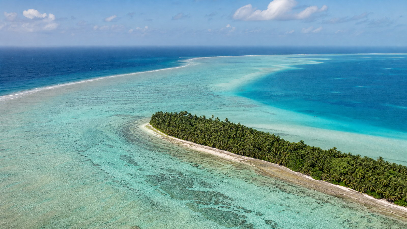
Lakshadweep is India's smallest Union Territory by land area but a vast marine geography: twelve atolls, reefs, submerged banks, and ten inhabited islands scattered in the Arabian Sea off the Kerala coast. Kavaratti is the administrative capital, while Agatti functions as the principal air gateway. The region's appeal is not interchangeable tropical scenery. Each island balances shallow lagoon, reef edge, coconut settlement, fishing culture, and faith in a different way; Minicoy adds its own Mahl-speaking, Dhivehi-linked cultural world. Travel is deliberately conditional here. Entry permission, transport capacity, sea state, protected-area rules, and local hospitality determine what is possible. A rewarding visit combines a few islands slowly, treats coral as living habitat rather than scenery, and leaves space for weather changes. The enduring experience is an understanding of how people live on low coral land surrounded by an immense and dynamic sea.
Regional notebook
Begin with the shape of the region.
Lakshadweep is a marine territory before it is a land destination. Its 32 square kilometres of land sit within a much larger realm of lagoons, territorial waters, reef systems, fisheries, and sea routes. The inhabited islands are small but varied: Kavaratti is administrative, Agatti is aviation-linked, Andrott is the largest by land, Kadmat is notably long and narrow, and Minicoy is culturally distinct. Tourism is therefore best understood as an addition to working island communities rather than a separate world. The most useful itinerary is selective, not exhaustive: choose two or three places with compatible access patterns, allow idle time, and give equal attention to settlement, reef, and weather.
Landscape
Geography changes the journey.
The archipelago lies about 220 to 440 kilometres from Kochi, between roughly 8° and 12° north. It comprises twelve atolls, three reefs, and five submerged banks, with ten inhabited islands and a large lagoonal expanse. Atolls pair low, permeable coral land with shallow lagoons, reef barriers, and exposed outer sea. There are no mountains or highland refuges: much of the land is only a few metres above sea level. Coral sand and limestone absorb rainfall quickly, so freshwater occurs as vulnerable lenses rather than in rivers. This geography explains both the clarity of lagoons and the limits on water, waste, construction, and emergency access.
Living culture
Arrive as a guest, not an audience.
The territory's indigenous population is predominantly Muslim, with Malayalam spoken across most inhabited islands and Mahl, a Dhivehi-related language, central to Minicoy. Religious life, mosques, fishing, coconut cultivation, coir work, and boat knowledge shape the cultural landscape. Kolkali and Parichakali are widely recognized folk forms; Minicoy is especially associated with Lava and with village-based Avah organization. Oppana is part of wedding celebration. These traditions are not staged scenery: they are embedded in households, worship, seasonal work, and community gatherings. Dress modestly, seek consent before photographs, and accept that an invitation or performance may not be available on a visitor timetable.
Curated regional atlas
Places that reveal different parts of Lakshadweep
This is a selective, geographically varied starting point rather than an exhaustive list. Use it to choose a coherent route, not to compress every place into one trip.
Administrative capital island and lagoon landscape · Kavaratti
Kavaratti Island
Kavaratti is Lakshadweep's administrative capital and a compact inhabited coral island set between a shallow western lagoon and the open Arabian Sea. The settlement combines government functions, coconut-lined lanes, mosques, narrow beaches, and a lagoon where reef life is visible in clear conditions. Its low elevation and central position in the archipelago make it an instructive introduction to the territory's spatial reality: land is scarce, the sea is close in every direction, and daily life is shaped by fishing, public services, boats, weather, and freshwater care. It is a lived island rather than a resort precinct.
Why this place matters
Choose Kavaratti for the broadest first view of Lakshadweep: capital-island rhythm, mosque architecture, lagoon ecology, and a practical base for understanding how coral atolls are inhabited. It suits travelers who prefer a cultural and civic dimension alongside water-based experiences, rather than a solely secluded-island stay. The west-side lagoon can offer a gentler setting than the outer sea, but reef, tide, wind, and visibility still govern what is sensible on a given day. Time ashore also rewards slow observation of settlement patterns, boat traffic, and the contrast between dense habitation and open water.
Historic mosque and religious architecture · Kavaratti Island
Ujra Mosque
Ujra Mosque is one of Kavaratti's most significant historic religious buildings, associated with Sheikh Mohammad Kasim and distinguished by elaborate woodwork. The seventeenth-century structure is described locally for an ornate ceiling traditionally said to be carved from a single piece of driftwood, as well as intricately worked pillars. It belongs to a still-active Islamic setting, not a museum detached from community life. Seen within Kavaratti's dense constellation of mosques, it offers a focused way to understand the religious and maritime cultural world that has long connected the islands with wider Indian Ocean networks.
Why this place matters
Visit, when appropriate, for architectural detail and for a quieter counterpoint to reef-centered itineraries. The value is not only the building's carving but the lesson that Lakshadweep's identity is lived through worship, community memory, and island-scale public space. Travelers interested in architecture, material culture, and local history will find more meaning here than those seeking a quick visual stop. Respectful timing and dress matter: this is a sacred place with community norms, and access can differ between spaces. Build the visit around the island's daily rhythm rather than expecting a fixed heritage-site routine.
Inhabited atoll island and aviation gateway · Agatti
Agatti Island
Agatti is a long, narrow inhabited coral island west of Kavaratti, with a substantial lagoon, fishing households, coconut and coir work, and Lakshadweep's airport. Its air link makes it an important arrival and departure point, but the island merits attention beyond logistics. The narrow strip of land places houses, palms, beaches, lagoon, and reef within a short walk of one another. In clear water, coral formations and reef fish are part of the island's visual character; in rough conditions, the same exposed marine setting explains why boat movement and water activities must be treated cautiously.
Why this place matters
Agatti suits travelers who want to begin with the practical geography of the archipelago: an operational airstrip embedded in a small island settlement, with lagoon ecology immediately beside it. It is a useful choice for short stays, snorkeling or glass-bottom viewing where conditions and supervision allow, and for appreciating the working lives behind the destination image. Its strong fishing economy gives the island a different texture from an uninhabited atoll. The trade-off is dependence on weather-sensitive onward movement, so it is wiser to allow a buffer than to stack tight same-day island changes.
Uninhabited coral island and lagoon · Bangaram Atoll, near Agatti
Bangaram Island
Bangaram is an uninhabited island enclosed by a shallow coral lagoon, with coconut cover, sandy shorelines, reef habitat, and birds and small terrestrial fauna. Its appeal lies in relative isolation and the legible shape of an atoll: pale sand, a protected lagoonal side, and the darker outer sea beyond the reef. Although it is often described through leisure imagery, its strongest value is ecological. The coral framework that creates the calm-looking lagoon is living habitat, while the limited land area and marine exposure make the island environmentally constrained and operationally dependent on conditions from nearby Agatti.
Why this place matters
Choose Bangaram for an atoll experience where landscape rather than settlement is central. It can suit travelers seeking quiet shore time, reef interpretation, and low-intensity water experiences under authorized supervision. Compared with Kavaratti or Agatti, there is less everyday civic life to encounter; compared with a remote sanctuary, it has a recognized visitor context. That distinction helps set expectations. Stay curious about the reef rather than treating it as a backdrop: tide timing, wind, and coral health shape the experience, and shore access or facilities should never be assumed to be constant.
Long coral island and lagoon landscape · Kadmat
Kadmat Island
Kadmat is a long, slender inhabited island between Amini and Chetlat, with a western lagoon, a sandy ridge, narrow beaches, and low coral terrain only a few metres above sea level. Its elongated form makes the relationship between lagoon and ocean especially easy to read: calmer shallows lie behind the reef while the outer sea has a different energy. The island is known in official tourism material for marine interpretation and supervised water activities, yet its more durable draw is the open, linear landscape of sand, palms, settlement, and lagoon. It is not a place for hurried island-hopping.
Why this place matters
Kadmat rewards travelers who want room to slow down and observe the physical structure of a coral island. The long shoreline, shallow lagoon, and sand accumulations create a more expansive walking and viewing experience than some denser islands. It can be well suited to reef-aware swimming, paddling, or diving only when local conditions, training, and authorized supervision make them appropriate. Its distance from the main air gateway is a real trade-off: the journey itself can be weather-sensitive. Give Kadmat enough time to absorb operational changes rather than treating it as a guaranteed short excursion.
Inhabited coral atoll and cultural landscape · Kalpeni
Kalpeni Atoll
Kalpeni is an inhabited coral-island landscape southeast of Kavaratti, associated with an elongated atoll, a broad lagoon, Cheriyam and smaller lagoon-side islets. Its pale shore, coconut cover, reef, and open lagoon are complemented by a close-knit community with strong social customs and an important local history of women's education. The atoll also carries a physical reminder of storm exposure: coral debris at the shoreline has been linked in tourism interpretation to a nineteenth-century tempest. Kalpeni therefore offers more than a beach setting; it is a place where weather history, family life, culture, and reef geography meet.
Why this place matters
Go to Kalpeni for a balanced view of Lakshadweep's natural and human dimensions. The lagoon allows visitors to understand why these reef systems support protected shallows, while the inhabited island keeps local culture and community norms in view. It suits a slower itinerary that values a village-scale atmosphere as much as water time. The trade-off is that a broad lagoon is not a promise of universally calm conditions: wind, tide, visibility, and official operating decisions still matter. Be especially attentive to locally designated areas and keep any coral or sandbar exploration low-impact.
Southern inhabited atoll and living cultural landscape · Minicoy
Minicoy Island
Minicoy, the southernmost inhabited island of Lakshadweep, is a crescent-shaped coral island with one of the territory's largest lagoons and a cultural identity distinct from the northern islands. Its people speak Mahl, a Dhivehi-related language, and organize village life through ten Avah communities with their own collective traditions. Painted homes, boat models, coconut groves, tuna fishing, Jahadhoni racing craft, and folk forms including Lava give the island a strong maritime character. A small mangrove cluster adds ecological interest, while its location near major sea lanes and far from the main gateway underscores its remoteness.
Why this place matters
Minicoy is the strongest choice for travelers who want cultural depth alongside a dramatic lagoon. The island's separate linguistic and village identity adds a meaningful dimension that cannot be replicated by simply moving between beaches. Allow time for respectful encounters with the settlement, maritime traditions, and slower island landscape rather than centering the visit on water activities alone. Its distance is the key trade-off: transport can take more planning and weather margins matter. The reef-sheltered lagoon may look inviting, but participants should follow local safety advice and avoid assuming that conditions are alike across every shore.
Historic maritime lighthouse · Minicoy Island
Minicoy Lighthouse
Minicoy Lighthouse is a nineteenth-century maritime landmark, commissioned in 1885 along a major Indian Ocean shipping route. Its tower combines coral stone from the island foreshore with black brick and cement, reflecting both local material context and colonial-era engineering. The lighthouse remains an aid to navigation and is the only surviving British-era structure in Lakshadweep according to its heritage record. From its coastal setting, it connects Minicoy's village landscape, reef-fringed sea, and the wider ocean route that has long shaped the island's history. It is a working heritage structure, not simply a viewpoint.
Why this place matters
This is Lakshadweep's clearest architectural link to global maritime history. It appeals to travelers interested in navigation, engineering, colonial-era infrastructure, and how a small island sits beside major sea traffic. Pair it with Minicoy's Avah villages and lagoon for a more complete picture: the tower is meaningful because it stands within a living island culture, not apart from it. The upper levels involve stairs and exposure, so it is not an equal-access experience. Treat any ascent as conditional on current supervision, opening arrangements, health considerations, and safety instructions.
Inhabited craft island and coral settlement · Amini
Amini Island
Amini is an oval, low-lying inhabited coral island between Kavaratti and Kadmat, with a central depression and land only a few metres above mean sea level. It is particularly valuable as a craft landscape: official descriptions note stone engraving, folk-song traditions, and work with coconut-shell materials. Coral stone and sandstone have historically been used in building, while the broader island economy has long been linked to coconut and coir. Amini's compact dimensions make it a revealing place to see how skill, housing, water, and everyday social life are concentrated within a highly limited coral landform.
Why this place matters
Amini adds a human-scale craft perspective that broadens a lagoon-focused trip. Travelers interested in material culture can appreciate how coconut, stone, and seafaring knowledge shape island expression, while the small settlement offers a counterpoint to uninhabited atolls. The right approach is observational and respectful: craft practices are part of community life, not automatically a performance for visitors. Materials and souvenir rules can be sensitive, particularly where wildlife protection applies. Allow enough time to move at local pace, and do not plan around an assumed workshop visit or a fixed display schedule.
Inhabited island and pilgrimage context · Andrott
Andrott Island and Juma Mosque
Andrott is Lakshadweep's largest inhabited island and differs from most of the chain in its east–west orientation and relatively small lagoon. Coconut vegetation, fishing, coir, and copra remain important components of its local economy. The island is closely associated with the tradition of Saint Ubaidullah, whose tomb is at the Juma Mosque and whose story is linked locally with the arrival of Islam in the islands. This gives Andrott a distinctive pilgrimage and historical dimension, set within a densely lived island where religious teaching, household life, and marine livelihoods coexist.
Why this place matters
Andrott is a thoughtful choice for visitors who want to understand Lakshadweep beyond reefs and water sports. Its scale, nearer position to the mainland, and sacred association provide a different lens on settlement history and religious life. Visit with the understanding that the mosque and tomb are living places of reverence, not architectural props. The modest lagoon also changes the landscape experience from the broad-lagoon imagery associated with other islands. Weather remains consequential: official island information notes that boats are not allowed outside the lagoon during the monsoon, so transport and outdoor plans should retain flexibility.
Protected coral islet and seabird habitat · Pitti Islet, near Agatti
Dr. Salim Ali Pitti Bird Sanctuary
Pitti, also called Pakshi or Bird Island, is a minute uninhabited oceanic coral islet near Agatti. It is a protected conservation landscape associated with coral reef, seagrass, seaweed, turtle nesting, and seasonal nesting by pelagic birds including sooty terns, greater crested terns, and brown noddies. Its significance lies precisely in its fragility: it has no visitor infrastructure, little land above sea level, and exposure to coastal erosion, wind, and saltwater pressure. Pitti should be understood as a breeding and ecological refuge within the wider atoll system, rather than as an ordinary island attraction.
Why this place matters
Pitti belongs in an atlas because it explains what responsible Lakshadweep travel protects. The islet makes visible the nesting, reef, and seagrass systems that underpin the region's biodiversity and enrich appreciation of inhabited islands nearby. For most travelers, the appropriate experience is learning about it through authorized interpretation or distant observation where allowed, not seeking a landing. Its conservation value is higher than any checklist value. Avoid wildlife disturbance, drones, collection, feeding, and unsanctioned approach; site status and seasonal protections should guide every decision.
Season and pace
Choose a date window for the experience, then keep a fallback.
For most travelers, September through May offers the broadest opportunity for water-based plans, with December through February often the busiest and comparatively comfortable. March through May can feel hot and humid despite sea breezes. The southwest monsoon commonly brings rain, wind, and rougher seas from around mid-May to September; island pages specifically note restrictions on boats beyond lagoons in that period. These are planning patterns, not guarantees. Coral visibility, swimming safety, vessel operations, and landing conditions may shift rapidly with wind, swell, tide, or official advisories. Check the active forecast and marine warning immediately before travel and again before each transfer.
Movement and planning
Distance on a map is not the same as usable travel time.
Moving through the region
Access is inherently limited. Agatti is the main air arrival point, while ships and inter-island boats connect parts of the territory from the Kerala coast and between islands. Transfers are not ordinary road journeys: schedules, passenger capacity, sea state, maintenance, and administrative decisions can change them. Minicoy and northern islands require particularly realistic time allowances. On land, distances are short, but compact lanes, jetties, sand, steps, heat, and boat boarding can create access barriers for travelers with limited mobility. Ask in advance about step-free rooms, jetty transfers, toilet access, assistance with luggage, motion sensitivity, and the practical route from arrival point to stay.
Building a workable route
Every non-native visitor needs to settle entry permission before departure; eligibility and documentation differ by traveler category, and international visitors have additional Indian travel-document requirements. Treat approval as separate from transport, lodging, and island access. Build the trip around confirmed legs rather than a long wish list, and retain at least one buffer night near a key arrival or departure. Carry sun protection, refillable water capacity, prescribed medicines, modest clothing for village and mosque settings, and low-waste essentials. Medical facilities, cash access, connectivity, supplies, and specialized accessibility support are limited by island scale. Confirm all changing details through the relevant local or official channel shortly before travel.
Travel responsibly
The regional context includes its limits.
Reefs create the islands' lagoons, fisheries, coastal protection, and much of their visitor appeal. Do not stand on coral, collect shells or wildlife, feed fish, touch turtles, chase birds, or use drones near nesting areas. Use only approved access and supervised water activities; a calm-looking lagoon can still have currents, sharp coral, boat traffic, heat risk, and sudden weather changes. Freshwater is finite because rain-fed lenses are sensitive to extraction and salinity, so take brief showers, reuse towels, and avoid unnecessary laundry. Keep plastic and food waste out of the marine system, carry reusable containers, and do not expect every island to absorb high-consumption habits. Respect mosque etiquette, residential privacy, and community-led conservation boundaries. If a transfer or activity is paused for weather or ecology, treat that restraint as part of visiting responsibly.
This is an evergreen regional guide. Weather, permits, closures, transport and local rules can change; confirm material conditions through the relevant local or official channel before travel.