North India · Union territory · LA
Ladakh
Ladakh is India’s high-altitude trans-Himalayan union territory: a cold desert of Indus-side settlements, plateaux, glaciated ranges and local cultures. Its joint capitals, Leh and Kargil, anchor travel geographies. Leh is the practical base for the Indus Valley, Nubra and Changthang; Kargil opens western valleys, Suru and Zanskar. Living monasteries, trade landscapes, wetlands and mountain towns bring variety. The trade-off is remoteness: altitude affects itineraries, services thin beyond towns, and weather or roads reshape plans. Acclimatise in Leh or Kargil, choose one or two landscape systems rather than every lake and pass, and leave contingency time. This is an introduction, not a Ladakh inventory.
Regional notebook
Begin with the shape of the region.
Ladakh rewards planning by landscape, not checklist. The Indus Valley combines Leh’s services with palaces, monasteries and irrigated villages. North of the Ladakh Range, Nubra is lower and greener in parts, with sand, orchards and caravan routes. Eastward, Changthang is an exposed plateau of lakes, wetlands and pastoral settlements, needing more time, altitude tolerance and flexibility. Kargil District offers another register: Muslim-majority mountain towns, old trade routes, memorial landscapes, cultivated Suru and remote Zanskar. These contrasts make a split Leh–Kargil itinerary meaningful. Use either town as a base, travel in measured stages and retain a spare day for conditions beyond a visitor’s control.
Landscape
Geography changes the journey.
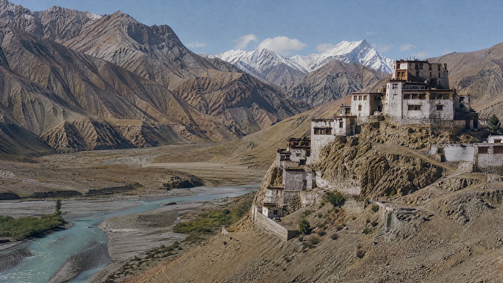
The territory lies in the greater Himalaya’s rain shadow, so dry rock, braided rivers and immense sky prevail over alpine forest. Altitude governs travel: Leh is around 3,500 metres, while Changthang lakes and road passes are considerably higher. The Indus forms the central settlement corridor; the Shyok and Nubra systems shape the north, and the Suru and Zanskar valleys are major western and southern counterpoints. Seasonal melt feeds willow-lined farms, barley fields and orchards in otherwise spare terrain. Landscapes shift quickly: salt margins at Tso Kar, brackish blue water at Pangong, wet meadows around Tso Moriri, Nubra apricots and glacier-facing Suru villages. Treat every high pass and unpaved stretch as a variable, not a scenic certainty.
Living culture
Arrive as a guest, not an audience.
Ladakh’s culture is plural, not a single mountain identity. Himalayan Buddhist monastic traditions are highly visible in the Indus, Nubra and Zanskar landscapes, where prayer halls, murals, masked rituals and farming villages remain part of daily life. Kargil and western valleys carry strong Muslim, especially Shia, histories alongside Buddhist, Dardic and Balti-related traditions. The official-language framework recognises Bhoti, Purgi, Urdu, Hindi and English while promoting Shina, Brokskat, Balti and Ladakhi. Food, oral traditions, music, craft and festivals are living practices, not staged scenery. At monasteries, mosques, village events and homes, dress modestly, ask before making images, keep voices low and follow directions about interiors, rituals and footwear.
Curated regional atlas
Places that reveal different parts of Ladakh
This is a selective, geographically varied starting point rather than an exhaustive list. Use it to choose a coherent route, not to compress every place into one trip.
Historic town and palace precinct · Leh town, Leh District
Leh Old Town and Leh Palace
Leh is Ladakh’s largest town, a high-altitude service centre whose older quarters climb beneath the former royal palace. Leh Palace, associated with the Namgyal dynasty and built in the seventeenth century, gives the town a strong vertical silhouette above lanes, neighbourhood shrines and market life. The appeal is not only the palace interior: walking the old fabric reveals how homes, water channels, religious sites and trade-era routes adapted to a dry mountain basin. This is the most useful place to understand the territory’s urban scale before moving into remote valleys.
Why this place matters
Begin here to acclimatise without sacrificing context. A slow day can join palace views, older lanes, local food and small religious sites while keeping effort modest after a flight. Leh also makes the contrast between royal history, Buddhist institutions, Muslim trading connections and present-day travel infrastructure visible at close range. It is the best base for deciding whether your next days should emphasise Indus Valley heritage, Nubra, Changthang or Kargil. Return at the end of a circuit for supplies, recovery and a final urban perspective rather than treating it as a transit stop.
Living Buddhist monastery · Thiksey, Indus Valley, Leh District
Thiksey Monastery
Thiksey is a large hillside monastery above the Indus Valley, recognisable for its stacked white buildings and broad view across cultivated ground and brown ranges. It remains a religious institution rather than a museum, with assembly spaces, chapels, monastic routines and ceremonial life embedded in the settlement landscape. Its tiered architecture makes the relationship between built form and terrain unusually clear: narrow passages rise through the complex while the valley opens below. The site works especially well as an early cultural excursion from Leh because it combines visual scale with a close encounter with a living monastic setting.
Why this place matters
Visit for a focused introduction to Ladakh’s monastic architecture without committing to a remote circuit. The climb and the light across the Indus Valley repay an unhurried morning, while the monastery provides a useful frame for understanding ritual, murals and community-supported religious life. Thiksey is a stronger choice than a hurried series of monasteries: allow time to observe quietly, absorb the setting and pair it with nearby village or palace landscapes. It also helps travellers see that religious heritage in Ladakh is actively used, not simply preserved as a historic backdrop.
Monastic heritage complex · Alchi village, Leh District
Alchi Monastic Complex
Alchi is a low-set monastic complex beside the Indus corridor, distinguished from the familiar hilltop silhouette by its village-scale setting and celebrated painted interiors. Its medieval religious art reflects links across the western Himalaya and makes it a key site for understanding Ladakh’s long artistic exchange rather than only its later royal history. The complex includes temples and devotional spaces whose fragile surfaces demand careful viewing. Alchi belongs naturally on a westward Indus Valley journey with Basgo or Lamayuru, though it can also be approached as a long, culturally dense day from Leh.
Why this place matters
Choose Alchi when painted art and historical detail matter as much as mountain scenery. The experience is quieter and more intimate than an elevated monastery: attention shifts from a far view to close observation of architecture, painted figures and the way a religious complex sits within a cultivated village. It balances Leh Palace’s royal story and Thiksey’s active hilltop presence. For travellers with limited time, it is a particularly high-value heritage stop; for slower travellers, it invites a western Indus itinerary that connects art, village life and dramatic geology.
Monastery and geological landscape · Lamayuru, Leh District
Lamayuru and the Moonscape
Lamayuru combines an ancient monastery with deeply eroded pale-brown landforms often called the Moonscape. At about 3,510 metres and roughly 127 kilometres west of Leh, it occupies a historic road corridor where religious architecture appears almost carved into a folded, dry landscape. The monastery’s tradition is associated with Naropa and it retains frescoes, masks and festival life alongside weathered structures. The geology is the second draw: gullies and ridges change colour through the day, giving the journey a distinct texture from the blue lakes and higher plains farther east.
Why this place matters
Go to connect a specific monastic tradition with an extraordinary physical setting, rather than for a single quick viewpoint. Lamayuru makes a convincing westward counterweight to Leh’s urban culture: its monastery compresses history and ritual, while the surrounding landforms explain why Ladakh is often read as a cold-desert landscape. It can be a thoughtful day return from Leh, but an overnight or onward journey allows better light and less rushed attention. It pairs naturally with Alchi and the western Indus corridor, offering a cultural route with fewer altitude jumps than Changthang.
High-altitude valley and cultural landscape · Diskit and Hunder, Nubra, Leh District
Nubra Valley: Diskit and Hunder
Nubra lies north of the Ladakh Range between the Karakoram and Ladakh ranges, shaped by the Shyok and Siachen river systems. It feels different from the bare Indus corridor: where water reaches the valley floor, there are orchards, shrubs and cultivated villages, while Hunder’s dunes introduce a cold-desert form rarely associated with the Himalaya. Diskit Monastery, founded in the fifteenth century, overlooks the valley and remains its major religious landmark. Nubra’s old caravan-route associations add historical depth to a landscape often reduced to dunes and camel rides.
Why this place matters
Choose Nubra for the clearest contrast within a Leh-based journey—sand, green village pockets, river valleys and monastery views in one circuit. Diskit gives the visit cultural focus, while Hunder demonstrates how wind, water and high mountains produce unexpected terrain. Two nights are preferable to a dash across a high pass because they reduce altitude stress and create time for villages, changing light and a slower return. Nubra is also a good reminder that Ladakh’s cultural geography includes trade routes and agricultural adaptation, not only monasteries and extreme roads.
High-altitude brackish lake · Durbuk–Tangste area, eastern Leh District
Pangong Tso
Pangong Tso is a long brackish lake in eastern Ladakh, reached from the Leh side across high mountain terrain. Its broad water surface, often intensely blue in clear conditions, is set against barren layered hills rather than a conventional lakeside town. The lake extends beyond India, making the surrounding approach subject to particular access and movement controls. Its appeal is elemental: shoreline, wind, colour and scale. That simplicity is also why it needs restraint. The lake is a high-altitude, exposed destination, not a casual day outing or a place where every shore is available for recreation.
Why this place matters
Visit Pangong for its stripped-back landscape composition: a horizontal band of water that changes with cloud, angle and wind, surrounded by mineral-coloured slopes. It is the right choice for travellers prepared to invest time in acclimatisation and a dedicated eastern circuit. Compared with Nubra, it offers less settlement variety and more exposure; compared with Tso Moriri, it has a more immediate road-trip character but still demands care. Stay only where current rules and local advice allow, keep plans flexible, and make the journey part of the experience rather than chasing a predetermined colour or photograph.
Ramsar wetland and pastoral landscape · Korzok, Changthang, Leh District
Tso Moriri and Korzok
Tso Moriri is a freshwater-to-brackish lake at about 4,595 metres in Changthang, recognised as a Ramsar wetland. Its shores include wet meadows and mineral-rich ground, while Korzok village and its old monastery introduce an inhabited, sacred dimension to the plateau. The wetland supports important birdlife, including black-necked cranes and bar-headed geese, and the wider plateau is habitat for kiang and other high-altitude fauna. This is not simply a larger lake stop: it is a cultural and ecological landscape where pastoral life, breeding habitat, scarce water and visitor pressure meet.
Why this place matters
Choose Tso Moriri over a second rushed lake if you want Changthang’s environmental and human context as well as dramatic water and mountains. Korzok anchors the visit in a real settlement and monastery landscape, while the lake makes the ecological stakes visible: high-elevation wetlands are unusually productive and unusually vulnerable. The trade-off is remoteness, cold and thin services, so this is best for a slower itinerary with a fully acclimatised group. Observant, low-noise wildlife watching can be deeply rewarding; chasing animals, off-route driving and lakeshore litter undermine the very qualities that make the journey worthwhile.
Ramsar wetland complex · Rupshu Plateau, Changthang, Leh District
Tso Kar Wetland Complex
Tso Kar is the ‘white lake’ of Changthang, named for salt efflorescence along its hypersaline margins. Its Ramsar wetland complex joins Tso Kar with freshwater Startsapuk Tso, creating a more varied system than a single lake viewpoint suggests. The basin is an important staging area on the Central Asian Flyway and a significant breeding landscape for black-necked cranes, geese, grebes and other birds. Wind, salt, seasonal water and wide grazing country define the experience. It is a place for careful observation, not high-volume recreation or close wildlife encounters.
Why this place matters
Go for a more ecological reading of Ladakh’s high plateau. Tso Kar shows how a saline lake, freshwater body, marshy margins and grazing landscape function together, and it offers a strong alternative to destinations valued mainly for a single dramatic photograph. Birders and patient landscape travellers will find depth in its changing water, salt edges and open horizons. The trade-off is exposure: weather is abrupt, facilities are limited and the environment is easily disturbed. Combine it with a well-paced Changthang route rather than treating it as a fast roadside stop between distant points.
High-altitude national park · Markha–Rumbak landscape, Leh District
Hemis National Park
Hemis National Park protects a large high-altitude landscape of dry valleys, rock faces, alpine and steppe habitats in eastern Ladakh. It is associated with snow leopard conservation but supports a broader community of bharal, Himalayan marmot, urial, wolf, fox, birds and drought-adapted plant life. Hemis Monastery within the wider park landscape links conservation with a major religious institution. The park is not a wildlife enclosure and sightings cannot be promised; its real value is the chance to understand why sparse mountain habitat, seasonal grazing, village life and conservation decisions must be considered together.
Why this place matters
Visit for a landscape-scale wildlife experience rather than a guaranteed animal encounter. In the right season and with responsible local guidance, valleys can reveal tracks, birds, blue sheep and the evidence of predator-prey relationships even when elusive species remain unseen. Treks and village-based routes add cultural context, but altitude and terrain make fitness, weather judgment and route discipline essential. Hemis is ideal for travellers willing to exchange certainty for ecological depth. It also provides a necessary counterpoint to road-based lake circuits by showing how conservation, grazing and remote communities coexist across a vast, dry mountain park.
Mountain town and memorial landscape · Kargil town and Drass, Kargil District
Kargil–Drass Corridor
Kargil is Ladakh’s second-largest town and joint capital, historically a meeting point for trade routes linking Central Asia, Kashmir and the Indian subcontinent. The corridor toward Drass follows a major mountain road through a landscape marked by the 1999 conflict and by everyday settlement, commerce and agriculture. Memorial sites invite sober reflection, while Kargil itself offers a valuable introduction to the district’s Muslim-majority cultural context and transport role. This is not a scenery-only transit stretch: its forts, mosques, Buddhist remains, rock carvings and war memory make it one of Ladakh’s most layered historical corridors.
Why this place matters
Choose this corridor to broaden a Ladakh itinerary beyond the Leh-centred image of monasteries and high lakes. Kargil’s position reveals old exchange networks, while Drass brings recent history into a landscape that remains a working road and mountain community. It is well suited to a Leh–Kargil journey with time to stop and listen, rather than a quick pass-through. The experience is strongest when approached with restraint at memorials and respect for local routines. It also provides a practical bridge into Suru and Zanskar, where the terrain and cultural texture change again.
Mountain valley and village landscape · Suru Valley, Kargil District
Suru Valley and Panikhar
Suru Valley is a cultivated, glacier-facing counterpoint to the drier valleys around Leh. Villages and fields follow the Suru River beneath high peaks, with the Nun–Kun massif forming a dramatic southern skyline from the Panikhar area. The valley’s greener appearance comes from water, farming and a lower, though still demanding, mountain environment; it should not be mistaken for an easy lowland escape. Suru introduces Ladakh’s Kargil-side landscapes through everyday agriculture, mountain views and routes that lead toward more remote valleys and mountaineering country.
Why this place matters
Go to see Ladakh’s relationship with water and cultivation at a scale that the highest plateaux cannot show. Suru is a strong choice for travellers who value village landscapes, longer mountain views and a less concentrated visitor circuit. Panikhar is a natural pause for observing fields, river terraces and the Nun–Kun skyline rather than merely ticking off a peak view. It pairs effectively with Kargil and can lead toward Rangdum or Zanskar, but the distances reward an overnight. Weather, road surface and mountain hazards remain part of the calculation even in this greener valley.
High-altitude valley and town · Padum and Zanskar, Kargil District
Zanskar Valley and Padum
Zanskar is a high-altitude semi-desert on the northern flank of the Great Himalayan range, with Padum as its principal town. Its long relative isolation has preserved a distinctive combination of Buddhist monasteries, village agriculture, river gorges and high passes, while newer road links are changing the pace of access. The valley should be understood as a place where people live through a short working season, not as an empty adventure arena. Padum is the practical orientation point; the wider valley rewards time for monastery landscapes, fields, local roads and changing geology.
Why this place matters
Choose Zanskar when you have enough days to let distance become part of the journey. It offers a more immersive valley experience than a Leh day excursion: the approach, Padum’s services, villages and monastic settings gradually reveal a distinct regional character. Its appeal lies in depth, not speed. Travellers can balance cultural visits with low-key landscape walks, but difficult terrain, limited medical support and variable transport make independent improvisation a poor strategy. Zanskar is best as a dedicated Kargil-side chapter, with flexible days for route conditions and an itinerary scaled to altitude and experience.
Dardic cultural landscape · Dha and Hanu villages, western Leh District
Aryan Valley: Dha and Hanu
The villages of Dha and Hanu sit in Ladakh’s western Indus-side cultural landscape and are associated with Brokpa communities and Dardic language traditions. They are part of a wider route that includes irrigated settlements, orchards and older pathways toward Kargil. This region adds an important corrective to simplified portrayals of Ladakh by foregrounding linguistic and cultural diversity within the territory. Its interest is not an imagined ‘unchanged’ past; it is the continuing relationship among village livelihoods, dress, festivals, language, farming and a borderland mountain environment.
Why this place matters
Visit to learn that Ladakh’s cultural map is broader than a single religious or architectural tradition. The landscape is more intimate than Changthang: villages, cultivated plots and the Indus corridor provide a setting for understanding how language and community identity persist in a modern, connected territory. A respectful visit should prioritise ordinary village pace over intrusive observation. This is a meaningful addition to an Alchi–Lamayuru or Leh–Kargil route for travellers who value cultural complexity and are willing to ask, listen and follow community guidance rather than treating residents as an attraction.
Season and pace
Choose a date window for the experience, then keep a fallback.
May–September usually offers the widest road, lake, trekking and monastic access, though warm days can turn very cold at elevation. Late September and October bring sharp visibility, golden fields and quieter valleys, but early snow may narrow options. From November–April, severe cold, snow, reduced services and closed mountain roads reshape travel; winter suits prepared visitors with a specific current plan. Ladakh is mostly dry, but intense weather can bring rockfall, landslides, flash flooding or transport interruption. Before each road day, check current weather, hazard messages, route status and local advice: a clear morning does not guarantee a pass or river valley.
Movement and planning
Distance on a map is not the same as usable travel time.
Moving through the region
Air arrivals make Leh accessible more often than land routes, but rapid elevation gain makes the first two days medically important. The Srinagar–Kargil–Leh road commonly operates longer than the Manali approach; both are seasonal and restrictions change. In winter, remote land movement may be extremely limited. Distances understate journey time because of altitude, road surface, traffic controls and weather. Vehicles, operating public transport and local drivers are practical, but time buffers remain necessary. Mobile service, fuel, repairs and medical care concentrate in larger settlements. Do not start a long remote day late, travel through a closure or assume a mapped shortcut is appropriate. Confirm current road, transport and fuel information through the relevant local or official channel.
Building a workable route
Build the itinerary around acclimatisation before ambition. Rest on arrival, take low-effort outings at similar elevation, then move to higher lakes, passes or trailheads. Headache, nausea, dizziness or unusual breathlessness mean stop ascending and seek qualified medical advice; severe symptoms require prompt descent and emergency care. Carry prescribed medicines, layers, sun protection, a reusable water system, food for delays and cash for areas with unreliable connectivity. Some border-adjacent, wildlife and remote circuits have entry rules that can change by nationality, season and conditions. Obtain valid permissions and follow route or timing instructions. Choose one eastern lake circuit or Nubra after Leh rather than cramming both into a rushed weekend; reserve extra days for Zanskar, Suru or a Leh–Kargil crossing.
Travel responsibly
The regional context includes its limits.
Ladakh’s high desert has limited water, fragile soils and small waste-handling capacity. Refill rather than use single-use plastic, carry litter from lakeshores and trailheads, and use toilets or waste systems rather than open ground. Wetlands are habitat, not picnic lawns: keep distance from nesting or grazing wildlife, stay on established approaches, keep noise low and never feed animals. A snow leopard, crane or wild ass sighting never invites pursuit. In villages, compensate fairly for guides, transport, homestays and craft work; do not enter fields, prayer spaces or homes without invitation. Avoid removing stones, fossils, artefacts, plants or religious objects. Match activity to experience, weather and local guidance. Confirm current conservation closures, protocols, access rules and emergency advice through the relevant local or official channel.
This is an evergreen regional guide. Weather, permits, closures, transport and local rules can change; confirm material conditions through the relevant local or official channel before travel.