South India · State · KA
Karnataka
Karnataka rewards a route-based journey rather than a single-base holiday. Its capital, Bengaluru, anchors a broad state that runs from the Arabian Sea and monsoon-soaked Western Ghats to dry northern plateaux and the boulder country of the Tungabhadra. Within that span are the surviving urban landscape of Vijayanagara at Hampi, Chalukyan temple ensembles in the Malaprabha valley, Hoysala carving, Mysuru’s royal and ceremonial traditions, coffee-growing highlands, and major forest habitats. The trade-off is distance: a coast-and-hills itinerary can be wet and slow when the northern heritage belt is hot and open. Build around one or two adjoining regions, leave space for weather, and treat wildlife sightings, water activities, road conditions, monument hours, and festival access as variable. Kannada is the state’s principal language, while local speech and foodways shift markedly from Kodagu to the coast and the Deccan interior. Karnataka is especially strong for travelers who value landscape as part of history, not merely a backdrop to monuments.
Regional notebook
Begin with the shape of the region.
Karnataka is a large, internally varied state whose most rewarding journeys follow geographic logic. Bengaluru is a practical gateway, but the old Mysuru region, Malaprabha and Tungabhadra basins, Western Ghats, and Arabian Sea coast each offer distinct climates, histories and tempos. The selection is representative, not exhaustive.
A first visit works best as Bengaluru–Mysuru–Kodagu/Bandipur, a northern Hampi–Chalukyan circuit, or a Ghats-and-coast route. Combining all of them needs substantial travel time. Historic sites reward early starts; protected areas require patience and staff compliance; coastal days depend on sea conditions. Move carefully across the contrasts rather than rushing a checklist.
Landscape
Geography changes the journey.
Karnataka runs from a narrow Arabian Sea coast across the Western Ghats to the Deccan plateau. The state government lists 191,791 square kilometres, explaining the substantial changes in weather, terrain and travel time. The Krishna, Kaveri and Tungabhadra systems shape the interior, while west-flowing rivers cut through the Ghats. Granite hills, river plains, lateritic coast, forested escarpments and cultivated plateau coexist.
The west is humid and steep; Kodagu and Chikkamagaluru can be cool but rainy and road-sensitive. Hampi, Badami and Pattadakal are open and hot. Southern forest country has controlled access. Elevation is moderate, yet ridge walks, heat, uneven stone and seasonal rain demand suitable pacing and footwear.
Living culture
Arrive as a guest, not an audience.
Kannada is a statewide thread, but Karnataka is culturally diverse. Tulu and Konkani are prominent on parts of the coast, Kodava identity is central in Kodagu, and Urdu, Marathi, Telugu, Tamil and other languages reflect trade, migration and borderland histories. Temple worship, Jain heritage, Islamic architecture, church communities, royal legacies and modern institutions coexist.
The monumental record runs from Early Chalukyan experiments to Hoysala carving and the Vijayanagara capital. These are living landscapes: temples remain active and festivals alter access. Coastal Yakshagana, Kambala and regional foodways add other local histories. Dress modestly at religious sites, remove footwear where required, ask before photographing rituals or people, and treat shrines, markets and working land with care.
Curated regional atlas
Places that reveal different parts of Karnataka
This is a selective, geographically varied starting point rather than an exhaustive list. Use it to choose a coherent route, not to compress every place into one trip.
capital city · Bengaluru Urban district
Bengaluru
Bengaluru is Karnataka’s administrative capital and largest urban gateway. Legislative architecture, public gardens, museums, older commercial quarters and a contemporary cultural scene sit within a highland metropolis that has expanded far beyond its historic core. It offers a useful introduction to the state’s modern institutions, design, food cultures and multilingual life before rural travel. The scale brings a clear trade-off: traffic can consume more time than maps suggest, and neighbourhood character changes sharply. Explore it selectively rather than treating it as a substitute for the state’s heritage or natural landscapes.
Why this place matters
Go for an intelligent opening or closing chapter. Bengaluru offers the widest onward connections, an introduction to Kannada public life, and a contrast with the temples, forests and coast beyond. Vidhana Soudha, Lalbagh, Cubbon Park and older market areas make a compact thematic day when sensibly clustered. It also offers stronger medical, transport and mobility support than remote areas. It is less suited to a quiet, low-traffic break; its cultural depth emerges from neighbourhood time, not a cross-city dash. Its public green spaces offer welcome breaks from the pace.
heritage city · Mysuru district
Mysuru
Mysuru is a heritage city at the foot of Chamundi Hills, shaped by the Wodeyar court, ceremonial avenues, gardens and an enduring reputation for art and festival culture. The Amba Vilas Palace is its visual anchor, but palace precincts, markets, lakes, hill shrines and collections reveal a fuller urban story. Its legible centre makes it a useful base for a slower cultural stay and nearby river or forest landscapes. It feels calmer than Bengaluru, although religious dates, weekends and Dasara can bring pronounced crowds and altered movement.
Why this place matters
Go to connect dynastic history with a living regional city rather than see a palace alone. Mysuru rewards architecture, collections, early hill views and planned civic spaces, and is a practical hinge between Bengaluru, Ranganathittu, Bandipur and Kodagu. Dasara can be meaningful for public ceremony but demands flexibility and crowd tolerance. Wilderness travelers should treat it as a gateway. Two nights allow the city to breathe; trying to pair every nearby attraction with the palace makes the experience rushed. Its compact central districts make this slower pace practical.
wetland and bird sanctuary · Near Srirangapatna, Mandya district
Ranganathittu Bird Sanctuary
Ranganathittu is a Kaveri river bird sanctuary near Srirangapatna, defined by small wooded islets and channels. Waterbirds, nesting colonies, crocodiles, riparian vegetation and careful observation are the focus. It provides an ecological counterpoint to Mysuru’s architecture and works in a compact Mysuru-area day. Its small scale means noise and crowd behaviour matter. This is not a guaranteed spectacle: bird diversity and visibility shift with season and water level, while boat movement is managed for safety and conservation. River flow and nesting cycles determine what is visible.
Why this place matters
Go for an approachable introduction to Karnataka wetland ecology and for birds rather than large-mammal chasing. The islets and cultivated river landscape show why waterways are ecological corridors and historic routes. It suits families, patient photographers and travelers with limited time near Mysuru, but not those seeking solitude or long walks. A quiet early or late visit, binoculars and a staff-led pace improve the experience. Pair it with Srirangapatna or Mysuru rather than creating a separate overnight. It also rewards travelers who prefer nature interpretation over rapid sightseeing.
tiger reserve and forest landscape · Chamarajanagar district
Bandipur Tiger Reserve
Bandipur is a protected forest landscape in southern Karnataka, within a larger cross-border ecological mosaic of deciduous woodland. Its importance is habitat continuity for elephants, tigers, dholes, deer, birds and less conspicuous life, not an assured view of one animal. Roads, vehicles and activities are controlled because this is functioning habitat. Dryness may make movement more visible; rain transforms vegetation and practical access. The experience is best understood through forest signs, light and scale, using authorised naturalist-led systems. Forest boundaries are ecological rather than visitor conveniences.
Why this place matters
Go to encounter a major South Indian forest system responsibly and understand why speed, noise and visitor numbers are conservation issues. Bandipur complements Mysuru and Kodagu, adding ecological context to a cultural route. It suits patient early risers who value birds, trees and ungulates alongside possible large mammals. It does not suit a rigid itinerary built around a tiger image. Leave time, do not press staff for off-route access, and treat a no-sighting drive as a complete forest experience. This approach supports better observation and less disturbance.
Western Ghats cultural landscape · Kodagu district, centred on Madikeri
Kodagu
Kodagu, widely known as Coorg, is a hilly Western Ghats district of coffee estates, forest edges, river catchments, small towns and Kodava cultural life. Madikeri is the main base, but plantation agriculture, sacred landscapes, waterfalls and high viewpoints define the region. Its economy is tied to coffee, forestry and agriculture, so working land deserves respect. Rain shapes vegetation, roads, leeches, mist, river flow and safe activity. Kodagu is best approached slowly, from one base, with short weather-aware excursions. Seasonal change is therefore fundamental to every itinerary decision.
Why this place matters
Go for a gentler mountain rhythm, coffee landscapes and a distinct regional identity rather than generic hill scenery. It works for travelers who enjoy viewpoints, short walks, local food and quiet observation, and pairs naturally with Mysuru or Bandipur. Dispersed attractions and curving roads make packed itineraries tiring; monsoon can slow any plan. Choose a small area, learn about Kodava context and let rain reshape the day. Estate access is not automatic and should never be assumed. This restraint also reduces pressure on fragile hill environments.
mountain and coffee region · Chikkamagaluru district
Chikkamagaluru and Mullayanagiri
Chikkamagaluru is a Western Ghats gateway where coffee estates, forested slopes, temple settlements and high ridges meet. Mullayanagiri, Karnataka’s highest peak, gives the region its mountain focus, but the deeper appeal is the transition from coffee country to mist-prone uplands. Roads and weather can make nearby-looking scenery feel remote. Cool mornings, cloud, rain and rapidly changing visibility are part of the place. Choose short walks, ridge views when conditions permit and measured driving rather than an all-weather viewpoint chase. Local weather therefore deserves more weight than a fixed schedule.
Why this place matters
Go for elevation, coffee landscapes and the shift from plateau cities to the Ghats. It suits travelers wanting nature without making a safari central, and can open a route toward the coast. Combine a modest ridge outing with time in the lower landscape, allowing cloud or rain to redirect the day. It is less suited to anyone requiring predictable views or universal step-free access. Do not overload a day with distant peaks, waterfalls and estates; each requires local road time and seasonal flexibility.
coastal temple town and beach landscape · Udupi district
Udupi and Malpe
Udupi and nearby Malpe combine a major temple town, working coast and broad Arabian Sea beaches. Udupi’s religious institutions, cuisine and daily rituals provide the core; Malpe adds fishing activity, sand and sea horizons. The Konkan coast’s humidity, monsoon intensity, tidal change and religious etiquette shape the experience. A good visit moves between town and shore without reducing either to backdrop. Early market activity, temple rhythms, local food and shifting coastal light can matter more than a sequence of beach stops.
Why this place matters
Go to experience coastal Karnataka through living temple and food culture as well as the sea. It suits travelers who want a cultural base with shore access and can observe sacred-space customs. Udupi connects the Ghats and northern coast, though hill crossings need conservative timing. It is not for assuming a swim-ready sea every season. Plan one temple-area visit and one coast segment, leaving room for heat, rain or altered marine conditions. This balanced approach makes a short stay more meaningful and safer.
pilgrimage town and coastal landscape · Uttara Kannada district
Gokarna
Gokarna is a Konkan-coast town where the Mahabaleshwar temple, beach coves, fishing activity and rocky headlands coexist. Pilgrimage is its strongest identity; the shore is a second landscape, not a replacement for the sacred centre. Temple areas require modest conduct, while coves and trails can be uneven and weather-sensitive. Seasonal sea conditions are decisive, especially in monsoon. The town suits visitors who can hold devotion, settlement life and coastal geology together without treating a living religious place as a beach setting.
Why this place matters
Go for the close meeting of pilgrimage context and Arabian Sea, with compact exploration on foot when weather permits. Headlands and beaches suit coastal walkers and unhurried pauses, while the temple town gives cultural weight. Do not assume every cove is safe for swimming or every path is accessible. Monsoon is visually powerful but operationally limiting. Centre the town, walk only safe open routes, and follow local tide and access advice rather than attempting cliff shortcuts. That restraint protects both visitors and an inhabited pilgrimage landscape.
Western Ghats tiger reserve and river landscape · Uttara Kannada district, near Dandeli
Kali Tiger Reserve and Dandeli
Kali Tiger Reserve, formerly Dandeli-Anshi, joins Dandeli Wildlife Sanctuary and Anshi National Park in a sensitive Western Ghats tract. Moist deciduous, semi-evergreen and evergreen forest meet valleys and the Kali river system, supporting elephants, big cats, deer, wild dogs, sloth bears, reptiles and resident hornbills. Dandeli is the practical town-side base, but the reserve is regulated habitat. River and forest activity varies with rain, staff decisions and safety. It is strongest for quiet wildlife observation, birding and learning how forest changes across a wet western landscape.
Why this place matters
Go for Western Ghats biodiversity rather than a guaranteed animal list. All four resident hornbill species give bird-focused travelers a reason to linger. The reserve can add forest depth to a Gokarna or Udupi route, though the road transition needs time. Keep conservation and water safety above recreation. Early starts, restrained expectations and attention to smaller life are rewarded. It is unsuitable for self-directed forest entry or for plans dependent on a fixed safari departure without reconfirmation. Patient observation is more appropriate than pursuit of rare sightings.
World Heritage cultural landscape · Vijayanagara district, Tungabhadra basin
Hampi
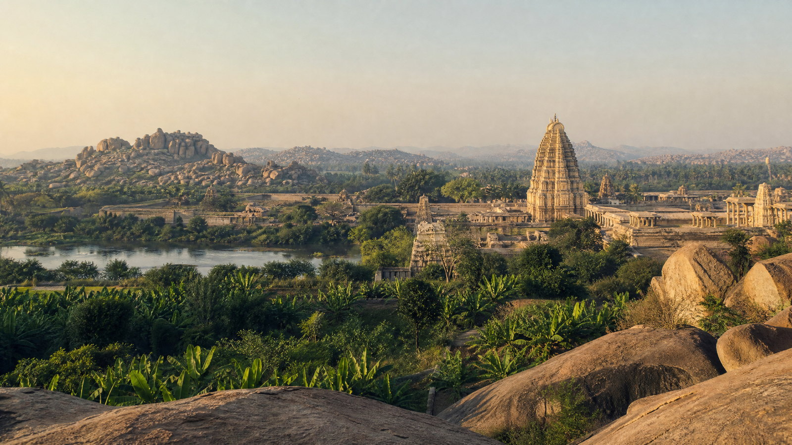
Hampi is an expansive cultural landscape of granite boulders, the Tungabhadra, sacred complexes, royal enclosures, bazaars, water structures and village life. It preserves Vijayanagara’s fourteenth- to sixteenth-century capital within a setting where geology and irrigation are inseparable from architecture. It is more than ruins: ritual, trade, water management and topography formed a planned, defended city. Virupaksha remains a living temple, while other zones are archaeological spaces. Open terrain magnifies its grandeur and heat, making pace as important as any monument list.
Why this place matters
Go for one of India’s clearest historic landscapes, where boulders, river, temples and urban remains explain one another. It suits travelers willing to walk slowly, return in different light and learn why water systems and processional streets matter. Conservation pressures are part of its present reality. The trade-off is exposure and distance between zones. Begin at dawn, pause at midday and resist trying to cover every complex in one day. Respect worship and every protected boundary. The landscape’s scale needs time, water and sun-aware pacing.
Chalukyan archaeological and temple landscape · Malaprabha valley, Bagalkot district
Badami, Aihole and Pattadakal
Badami, Aihole and Pattadakal are a Malaprabha-valley study in Early Chalukyan architecture, not three interchangeable stops. Badami sets rock-cut caves and temples against red sandstone cliffs; Aihole preserves experiments in temple form; Pattadakal presents a mature dialogue of northern and southern idioms in a World Heritage ensemble. They are separated by rural roads and open country, so their relationship needs at least a full day. These are sacred, archaeological and hot plateau landscapes, requiring respect, shade and deliberate pacing. Light and shade strongly influence the experience of carved stone.
Why this place matters
Go to see architectural ideas develop across a valley, rather than collect isolated temple images. Pattadakal’s Virupaksha and Mallikarjuna give a high point; Aihole and Badami reveal the experimentation behind it. It suits readers of art, religion and building technology and adds contrast to Hampi’s imperial scale. It does not reward a rushed day from afar. Look closely at plans, carvings, caves and the landscape between them, allowing time for shade and active-shrine etiquette. A restrained pace improves both safety and architectural understanding.
Hoysala temple towns · Hassan district
Belur and Halebidu
Belur and Halebidu are complementary Hoysala temple towns whose soapstone carving, star-like plans and narrative reliefs demand close looking. Belur’s Chennakesava Temple remains an active sacred precinct; Halebidu’s Hoysaleswara complex offers densely worked exterior sculpture. Their artistry does not make them stone museums: ritual, settlement and conservation are active parts of the setting. They fit a routeable but not instant triangle with Hassan and the Ghats. Two compact sites can fill a thoughtful architecture-first day. Patient looking reveals how craftsmanship and sacred use remain intertwined today.
Why this place matters
Go for some of Karnataka’s most intricate medieval carving at a scale that contrasts with Hampi’s vastness. These temples reward time with individual panels, processional space, ceilings and plan. A guide or reading can help with dense iconography. They are less rewarding as quick exterior photographs. Pair them with Chikkamagaluru for a culture-and-hills route or use Hassan as a base. Keep plans flexible around prayer activity and conservation-managed areas. Careful attention brings out their narrative richness and spatial intelligence. Its details reward repeated, unhurried observation.
Season and pace
Choose a date window for the experience, then keep a fallback.
October–February is the most flexible statewide period: post-monsoon skies are often clearer, northern days are more manageable, and heritage walks are easier. It is also popular. March–May brings serious heat in the northern interior and around Bengaluru; visit exposed sites early. Hills may feel milder, but afternoons remain warm.
June–September is not a uniform off season. Coast and Ghats receive intense rain, producing greenery but also slippery steps, leeches, reduced visibility, rough seas, flash-flood risk and slower roads. October–November can retain showers. Bird activity, river conditions, trekking access, boating and safari operations change with rainfall and management. Check current weather, hazards and operations before travel.
Movement and planning
Distance on a map is not the same as usable travel time.
Moving through the region
Bengaluru has the strongest air, rail and road connections. Rail serves major corridors, while buses reach many rural districts; a hired vehicle reduces friction on dispersed routes but does not remove long journey days. Ghats roads are winding, monsoon movement can be slow, and driving after dark is unwise where wildlife, fog or rain matter.
Use Mysuru, Hospet, Madikeri, Chikkamagaluru, Udupi and Dandeli as regional bases. Hampi is spread across a large landscape; Badami, Aihole and Pattadakal need local road time; protected-area entry is separate from reaching a town. Step-free access is uneven. Confirm current accessible entrances, vehicle permissions, toilets and assistance through the relevant local or official channel.
Building a workable route
Choose a primary focus: heritage, mountains and plantations, wildlife, coast or city culture. A northern circuit needs Hampi plus the Malaprabha valley; a southern one can pair Mysuru with Ranganathittu, Bandipur and Kodagu. Do not treat transfer days as sightseeing days: rain, traffic, wildlife controls and monument walking lengthen them.
Carry water, sun protection and a modest layer for sacred places; add rain protection and grippy footwear in monsoon or hills. Leave a flexible day near the Ghats or coast. Confirm current entry rules, closures, festival restrictions, transport, photography rules, accessibility, guide availability and weather advisories through the relevant local or official channel.
Travel responsibly
The regional context includes its limits.
Karnataka’s best places are shared cultural or ecological spaces. At Hampi and Chalukyan sites, stay on paths, never climb or touch fragile stonework, and do not use drones without clearance. Active temples require quiet conduct. Ask before close portraits and do not treat working communities as a spectacle.
In forests and wetlands, wildlife welfare comes first: keep distance, remain where instructed, never feed animals, avoid flash and accept no large-animal sighting. Carry out litter and keep noise low. Swim or boat only when local safety guidance permits; coastlines and rivers change quickly. Spend locally where possible and respect weather- or conservation-led closures.
This is an evergreen regional guide. Weather, permits, closures, transport and local rules can change; confirm material conditions through the relevant local or official channel before travel.