East India · State · JH
Jharkhand
Jharkhand is a plateau state shaped by sal forest, river-cut escarpments, mineral landscapes and a deeply plural cultural life. Ranchi is a useful gateway for waterfalls, services and short plateau excursions, while the western plateau opens into Netarhat and the regulated forests of Palamau. In the south and east, the Dalma Hills, Jamshedpur’s planned-industrial landscape and Saranda’s sal canopy make a more remote proposition. Deoghar, Rajrappa, Maluti and Parasnath add major Hindu, Shakta, terracotta and Jain sacred geographies. The strongest journeys make room for this range rather than compressing it into a waterfall circuit. Cooler months are most comfortable; monsoon brings full rivers but much greater weather and road uncertainty. Forest visits, hill walks and pilgrimage days need a slower, confirmation-led approach. It is a state best understood through these contrasts, not a standardised circuit.
Regional notebook
Begin with the shape of the region.
Jharkhand rewards travellers who treat it as connected but distinct regions, not a checklist. The Chota Nagpur Plateau supplies the visual grammar: wooded ridges, lateritic ground, reservoirs and rivers that drop into falls. Ranchi concentrates services and nearby water landscapes. Latehar and Palamau offer a slower western forest itinerary; the Singhbhum districts combine elephant country, Saranda’s sal horizon and Jamshedpur’s urban-industrial setting. The north-east carries the Jain pilgrimage of Parasnath, while Deoghar and Rajrappa are powerful Hindu sacred centres. Dumka’s Maluti adds intimate brick-and-terracotta heritage.
There is no coast circuit here, and wildlife travel is not an entitlement to sightings. The appeal lies in contrast: a city waterfall can sit beside a long forest road day, or a crowded temple procession beside a quiet heritage village. Build around one or two anchors. This selective record is a balanced starting set, not a literal inventory.
Landscape
Geography changes the journey.
Most of Jharkhand lies on the Chota Nagpur Plateau, whose upper catchments feed the Koel, Damodar, Brahmani, Kharkai and Subarnarekha. This produces the alternating pattern of open plateau, cultivated basin, river gorge and forested hill. Sal defines many landscapes, shifting from dry peninsular and mixed deciduous stands in Dalma to the larger canopies of Saranda and Palamau.
Elevation softens some Ranchi and Netarhat heat but does not make the region alpine. Parasnath reaches about 1,350 metres; Dalma and Palamau remain uneven rather than high. Monsoon water transforms falls and reservoirs rapidly. Rock, steps and river edges may remain hazardous after rain. Map distances conceal slow final approaches, so retain daylight margins in rural and hill sectors.
Living culture
Arrive as a guest, not an audience.
Jharkhand’s culture is living, regional and multi-voiced. State material identifies 32 tribal communities, including Santhal, Munda, Oraon, Ho, Kharia, Birhor and Paharia communities, alongside long-established non-tribal communities and layered Jain, Buddhist, Bengal and other histories. Festivals, music and dance are community life, not performances on demand. Seraikela Chhau, Sarhul, Karma and Tusu belong to this wider landscape, but meaning changes with place, season and hosts.
Sohrai and Kohvar painting traditions deserve special care. Natural-pigment motifs, often linked to harvest and marriage, are household knowledge, not decoration to copy. Maluti, Deoghar and Parasnath show how devotional architecture overlaps with cultural plurality. Ask before photographing people, ritual, homes, artworks or gatherings. Learn a few Hindi greetings and favour consent-led encounters over staged expectations.
Curated regional atlas
Places that reveal different parts of Jharkhand
This is a selective, geographically varied starting point rather than an exhaustive list. Use it to choose a coherent route, not to compress every place into one trip.
capital city and waterfall landscape · Ranchi district
Ranchi Plateau and Waterfalls
Ranchi, Jharkhand’s capital, is the most useful entry point for reading the plateau’s water geography. Beyond its active urban centre, rivers cut through rock and forest edge at Dassam, Jonha and nearby falls. Dassam lies on the Kanchi River; Hundru is on the Subarnarekha. Ranchi also supplies the services, markets and onward connections needed for Netarhat, Ramgarh, Deoghar and Jamshedpur. Treat it as both a city and a logistical hinge, not merely a stop between waterfalls. A lake-side evening or unhurried urban morning adds needed context to a landscape-led itinerary.
Why this place matters
Choose Ranchi for a manageable introduction before longer rural transfers. It lets first-time visitors calibrate weather, roads and local rhythm while retaining access to plateau scenery. Nearby falls are visually strong after rain, but a visit works better when paired with slower city time than an all-day rush. Its trade-off is that popular sites can be busy and weather-sensitive; travellers wanting forest immersion should continue to Palamau, Dalma or Saranda. Ranchi suits visitors who value services without abandoning a landscape-focused journey.
waterfall and river gorge · Ranchi district
Hundru Falls
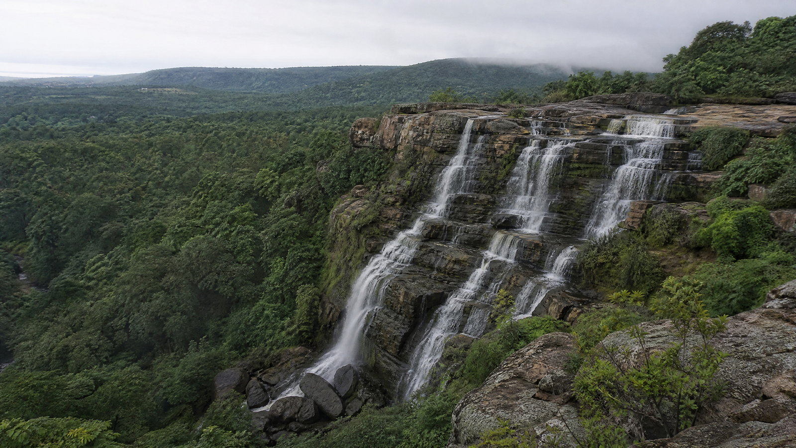
Hundru Falls is a major Subarnarekha River drop east of Ranchi, where water falls roughly 98 metres through weathered rock. It is one of the state’s clearest illustrations of plateau rivers creating abrupt vertical drama at an escarpment. The experience changes through the year: monsoon brings volume, spray and a powerful soundscape, while drier months reveal more erosion-shaped rock. This is a natural viewpoint rather than a water-play attraction. Descent areas require care where wet stone, crowding or changing river flow make footing uncertain.
Why this place matters
Go for a concentrated expression of the Ranchi plateau rather than an adventure itinerary. The height, escarpment setting and Subarnarekha course make Hundru more substantial than a quick roadside stop, and it pairs naturally with Ranchi. It suits landscape photographers able to work with early light and uncertain skies. The trade-off is seasonality: winter generally means easier movement and exposed geology, while rains produce fuller water but more safety uncertainty. Admire the river from authorised viewpoints rather than trying to reach it.
hill plateau and viewpoint region · Latehar district
Netarhat Plateau
Netarhat occupies the western Chota Nagpur highlands in Latehar district, valued for broad horizons, forest margins and changing light rather than dense built attractions. Often called the Queen of Chhotanagpur, it is associated with sunrise and sunset views, Magnolia Point, Koel viewpoints and the Upper and Lower Ghaghri Falls. It is also the scenic transition between Ranchi’s urban plateau and Palamau’s larger forest landscape. The appeal is unhurried: cool-season mornings, open sky and side roads that need patience. It is not a conventional mountain resort; basic services and weather resilience matter.
Why this place matters
Netarhat is for travellers who want room around a journey. Its viewpoints work best at the beginning or end of the day, leaving time for falls and forest-edge scenery. Compared with Ranchi it feels more spacious and cooler in winter; compared with Palamau it centres plateau atmosphere rather than regulated wildlife. The trade-off is distance and limited after-dark flexibility, so an overnight is preferable to an ambitious day return. Come for light, horizon and slower rhythm, not fixed panoramas in cloud.
tiger reserve and national park · Latehar district
Palamau Tiger Reserve and Betla
Palamau Tiger Reserve is Jharkhand’s only tiger reserve and among the earliest created under Project Tiger. On the western Chota Nagpur Plateau, it combines sal forest, mixed deciduous woodland, bamboo, river catchments and elevations of roughly 300 to 1,140 metres. Betla National Park is part of this protected landscape and the main visitor focus. The reserve’s scale matters: it covers more than a thousand square kilometres, while only a defined area is for tourism. It is habitat first, with wildlife moving on its own terms. Forest texture, history and watersheds matter as much as sightings.
Why this place matters
Choose Palamau for a real forest stay, not a hurried safari expectation. It offers a way to understand western Jharkhand’s watershed forests, sal habitat and the relationship between protected landscapes and neighbouring communities. Betla is the logical visitor base, but two nights or more allows early starts and quiet time. The trade-off is strict seasonality and operational change: the forest department publishes a monsoon tourism closure, and wildlife never follows a schedule. It suits patient naturalists willing to put conservation rules first.
sal forest and hill landscape · West Singhbhum district
Saranda Forest
Saranda is the vast sal-forest landscape of West Singhbhum, commonly introduced as the land of seven hundred hills. Its value is not one landmark but continuity of canopy, ridgelines and forest corridors within the Chota Nagpur biogeographic zone. The forest division identifies connections toward Odisha and Chhattisgarh and cultural links of Ho, Munda and Oraon communities. Travel here feels more remote than the Ranchi waterfall belt: views are dispersed, services thinner and access tied to forest conditions. Its scale, silence and seasonal colour matter more than covering every track.
Why this place matters
Saranda is for a forest landscape with cultural and ecological depth, not a guaranteed wildlife show. Dense sal canopy and rolling hills offer a markedly different experience from temple towns and cities. A guided, permission-aware approach can be rewarding without intensive activity: forest-edge observation, local context and time at authorised viewpoints are enough. The trade-off is real remoteness. Administrative, security or weather conditions may affect stays and movement, while monsoon slows tracks. Select Saranda only with flexible dates, respect for restrictions and acceptance that some areas may be unavailable.
wildlife sanctuary and hill forest · East Singhbhum and Seraikela-Kharsawan districts
Dalma Wildlife Sanctuary
Dalma Wildlife Sanctuary rises above Jamshedpur along the Dalma Hills, forming a forested counterpoint to the industrial city below. The sanctuary covers roughly 193–195 square kilometres across East Singhbhum and Seraikela-Kharsawan, with dry peninsular sal and northern dry mixed deciduous forest. Hills reach about 915 metres, and the landscape is especially associated with Indian elephants. Seasonal leaf fall, summer dryness and monsoon renewal define its character. Proximity to a large city can make it appear simple to visit, but wildlife travel here still requires restraint, distance and attention to forest rules.
Why this place matters
Dalma suits travellers wanting a forest day or overnight near Jamshedpur without mistaking proximity for domestication. The hill forest’s view toward the city and its relationship with Dimna make a distinctive meeting point of ecology, watershed and urban region. It rewards birding, forest observation and attention to deciduous-season change. The trade-off is that elephant habitat requires careful behaviour and access may be management- or weather-dependent. Go for forest texture and protected-landscape learning, not close animal encounters or unstructured hill wandering.
planned industrial city and reservoir landscape · Jamshedpur and Boram Block, East Singhbhum district
Jamshedpur and Dimna Lake
Jamshedpur introduces a different Jharkhand: a planned industrial city framed by the Dalma Hills, parks and water infrastructure. Dimna Lake, an artificial reservoir in Boram Block near the sanctuary, supplies water to the city and places a broad reflective surface beneath the range. It is useful precisely because it is not wilderness. The pairing shows the relationship between a major urban economy, a working reservoir and protected forest nearby. The city supplies the transport, food and services that make Dalma accessible, while the lake offers a cool-season scenic pause and hill-framed perspective.
Why this place matters
Go to understand how Jharkhand’s urban-industrial and ecological stories overlap. Jamshedpur provides an easier base than a forest-edge town, while Dimna creates an immediate visual link to Dalma. This pairing works well around a sanctuary visit and suits travellers who see infrastructure as part of place. The trade-off is that shore use, water activity and crowd levels vary with season and management. It is best as a city-and-hills orientation half-day, not a substitute for a protected-area visit. Winter mornings can be atmospheric, though haze softens distance.
pilgrimage city and temple complex · Deoghar district
Deoghar and Baidyanath Dham
Deoghar is one of Jharkhand’s principal sacred cities, centred on Baidyanath Dham, a complex of 22 temples whose tallest shrine rises about 72 feet. The central temple houses one of the twelve Jyotirlingas, making this a living pilgrimage destination rather than a heritage structure viewed at leisure. During Shravan, devotees undertake a long water-bearing journey from Sultanganj before worshipping here, and many continue toward Basukinath. Beyond the core, Deoghar has hill, ashram and temple contexts, but the essential experience is devotional rhythm: queues, bells, ritual sequence and worshippers whose priorities come first.
Why this place matters
Deoghar belongs on an itinerary for a major living sacred landscape and insight into eastern India’s pilgrimage networks. The temple core offers intensity and architectural density, while the surrounding town can support a slower second day. It is strongest outside the highest pilgrimage surge, when visitors can observe without adding pressure to circulation. The trade-off is that religious calendars override ordinary sightseeing logic. During Shravan, routes, queues and security can change quickly. Arrive with time, dress modestly and follow instructions without expecting photography or movement privileges.
heritage village and terracotta temple group · Shikaripara area, Dumka district
Maluti Temple Village
Maluti is an intimate Dumka-district heritage village where clusters of brick temples hold rich terracotta work within a rural setting. Historical accounts associate temple building with Malla rulers and artisans between the seventeenth and nineteenth centuries. Plaques depict Ramayana and Krishna episodes, deities, social scenes and ornamental forms, using moulded brick rather than monumental stone. Sources differ on the surviving count after the original 108 temples; the durable point is that dozens remain, alongside the important Mauliksha shrine. The village’s scale is its power: it asks for close looking, low impact and recognition that conservation needs remain active.
Why this place matters
Choose Maluti for a slow heritage visit where craft, landscape and conservation are inseparable. The group rewards interest in eastern Indian terracotta, small sacred architecture and the way a village setting changes monument experience. It is a strong counterpoint to Deoghar: quieter, more fragmentary and dependent on patient visual attention. The trade-off is limited visitor infrastructure and vulnerable fabric. Erosion, vegetation, waterlogging and encroachment have been identified as threats. Visit in daylight, do not touch plaques or enter unstable areas, and accept local guidance on what may be approached.
sacred mountain and Jain pilgrimage landscape · Giridih district
Parasnath and Sammed Shikhar
Parasnath is Jharkhand’s highest hill range, rising to about 1,350 metres in Giridih district. Known to Jains as Sammed Shikhar, it is among the religion’s most important pilgrimage landscapes: tradition holds that twenty Tirthankaras attained salvation here, and associated shrines mark the hill. The mountain has overlapping meanings; Santhals know it as Marang Buru, the hill of the deity. That shared but distinct significance is central to respectful travel. Although rail serves the wider area, the sacred ascent is not a casual viewpoint walk. It combines weather exposure, fitness, ritual etiquette and changing arrangements.
Why this place matters
Go for a serious sacred-mountain experience, not merely a state high point. The landscape offers forested slopes, highland air and insight into Jain devotional geography, while the Santhal name shows that one ridge carries more than one cultural meaning. It suits fit travellers willing to move at a pilgrimage pace and respect quiet, diet, dress and photography norms. The trade-off is physical and ethical: rain, heat, cloud and fatigue can change the day, and insensitive behaviour can disturb worshippers. A base-and-ascent plan is better than a rushed transfer.
Shakta pilgrimage and river confluence · Ramgarh district
Rajrappa Chhinnamastika Temple
Rajrappa is a major Shakta pilgrimage landscape at the confluence of the Bhairavi and Damodar rivers, about 28 kilometres from Ramgarh. Its focus is the Chhinnamastika Temple, a living shrine with an intense ritual atmosphere and associated temples. The meeting of rivers gives the site a physical as well as devotional identity: water, rock, temple movement and seasonal crowd flow shape the visit. The setting is significant year-round, with especially large gatherings near new- and full-moon observances. It should be approached as active worship, where ritual and local management take priority over leisurely monument viewing or photography.
Why this place matters
Rajrappa is worthwhile for the geography of devotion: river confluence and Shakta shrine form one integrated destination. It contrasts with Deoghar’s Jyotirlinga complex and fits a Ranchi–Ramgarh route without a major detour. Visit outside the largest observances for a calmer experience and more room to understand the setting. The trade-off is intensity. Crowds, queues, sound and ritual activity can be substantial, while wet riverbanks require care. It suits culturally curious travellers comfortable with a sacred environment that does not reorganise itself around visitor convenience.
reservoir, valley road and industrial landscape · Ramgarh district
Patratu Valley and Dam
Patratu combines a working reservoir, surrounding hills and winding valley-road scenery west of Ramgarh. The dam, also associated with the Nalkarni River, was built to supply the Patratu Thermal Power Station; water from nearby hills and falls feeds the reservoir. This practical origin is crucial to reading the view. Hills border the water on several sides, creating broad vistas and serpentine road perspectives popular in winter. A nearby temple adds a sacred layer, but the distinctive character is the overlap of water infrastructure, plateau topography and a widely used road corridor. It is a scenic pause, not isolated wilderness.
Why this place matters
Choose Patratu for an accessible illustration of infrastructure meeting plateau landscape. It works as a half-day extension from Ranchi or Ramgarh, especially for visitors wanting open water and hills without a long forest transfer. The reservoir is a useful counterpoint to Ranchi’s river gorges. Its trade-off is popularity: weekends can mean traffic and roadside crowding, while fog, rain or works alter views and driving. Instead of chasing one road image, use authorised viewpoints and read the water body as part of regional energy and water history.
Season and pace
Choose a date window for the experience, then keep a fallback.
November through February is the broad travel sweet spot, making city walks, viewpoints and road journeys easier. Ranchi winter days are generally mild, although early mornings and exposed ridges can feel cool. March through mid-June is hot; May may bring daily highs near 37°C around Ranchi, with harsher conditions in lower exposed sectors. Start early, carry water and avoid demanding outdoor activity in the hottest afternoon.
Main rains usually dominate roughly July–September. They bring full waterfalls and green forest, but also downpours, lightning, mud, poor visibility and local road disruption. Palamau publishes a monsoon closure for park tourism; other forest and water sites can alter access. October may remain wet and March may already feel hot. Check current weather warnings, road conditions and site guidance before each transfer.
Movement and planning
Distance on a map is not the same as usable travel time.
Moving through the region
Ranchi is the practical hub, with air links and major roads; rail helps on selected corridors including Parasnath, Deoghar and Jamshedpur. Jamshedpur and Daltonganj are useful secondary bases; Ramgarh, Giridih, Dumka and Deoghar suit place-specific stops. A hired vehicle with a local driver gives flexibility for falls, forest edges and viewpoints, but does not guarantee quick travel: rain, works, traffic, wildlife management and unpaved final stretches alter timings.
Do not assume scenic roads are suitable after dark, especially in monsoon or forest. Regulated landscapes may use specific gateways, time windows or temporary restrictions. Public transport connects main towns but is less forgiving for precise same-day site schedules. Keep rural transfers short, share a next-stop plan with accommodation and reconfirm final approaches through a relevant local or official channel.
Building a workable route
A first visit works best as a focused arc. Ranchi plus Hundru and a plateau day suits a short break; Ranchi, Netarhat and Palamau make a western nature route; Jamshedpur, Dalma and Saranda form a south-eastern forest-and-city combination; Deoghar, Maluti and Parasnath create a longer heritage-and-pilgrimage route. Rajrappa and Patratu fit between Ranchi and Ramgarh, but should not be rushed on a festival or wet-weather day.
Treat sacred places as active settings, not quiet monuments. Shravan in Deoghar and lunar observances at Rajrappa can radically change crowds and services. At Parasnath, assess fitness, footwear, weather and devotional etiquette rather than relying on a generic hill-walk estimate. For every forest area, confirm opening status, permitted activity, vehicles and stay arrangements through the relevant local or official channel. Carry offline maps, water, a rain layer and modest clothing.
Travel responsibly
The regional context includes its limits.
Jharkhand’s forests are wildlife habitat, water catchment and the lived environment of neighbouring communities. Keep vehicles on authorised roads, never approach animals, avoid playback and flash photography, and accept that a wildlife visit may yield no sighting. Do not enter closed trails, climb barriers, swim near waterfalls or treat monsoon rivers as predictable. Carry waste out where collection is limited and avoid single-use material at viewpoints and temples.
Respect layered rights and meanings in sacred and community places. Follow dress, photography and queue guidance; do not photograph worshippers, ceremonies, homes or art without clear permission. Purchase crafts only when a maker or transparent community outlet can explain origin, and do not imitate ritual art. In rural areas, a patient low-volume visit is preferable to an intrusive one. Conditions, access, warnings and sensitivities change; confirm them through the relevant local or official channel before travel.
This is an evergreen regional guide. Weather, permits, closures, transport and local rules can change; confirm material conditions through the relevant local or official channel before travel.