North India · Union territory · JK
Jammu and Kashmir
Jammu and Kashmir is a high-contrast Himalayan union territory where lake-and-garden Srinagar, the pastoral Kashmir Valley, Pir Panjal mountains and warmer Jammu foothills make very different journeys. Srinagar is the summer capital and Jammu the winter capital, reflecting movement from subtropical plains through Shivalik ridges to temperate valleys and high mountains. The Jhelum, Chenab and Ravi shape its drainage; lakes, forests, meadows, pilgrimage routes and Dogra-era heritage broaden an itinerary beyond one valley circuit. Kashmiri crafts, literary and musical traditions and living religious landscapes sit alongside Jammu’s Dogri culture. A trip can shift in a few hours from urban water lanes and formal gardens to a forested national park, a high meadow or a busy shrine route. Weather, conservation rules, crowd management and road conditions need flexible pacing. Give each landscape adequate time, respect local rhythms, and plan around seasonal realities rather than promises. This is a considered selection of signature places, not an exhaustive directory.
Regional notebook
Begin with the shape of the region.
Jammu and Kashmir rewards an itinerary built around contrasts, not a checklist. Srinagar is a cultural and logistical base for lakes, gardens, museums and nearby wildlife; Gulmarg, Pahalgam and Sonamarg each read the valley’s mountain edge differently. Gurez and Wular add remote-valley and wetland perspectives, while Verinag, Martand and Naranag connect spring, archaeology and sacred landscape. Jammu city and Katra open a distinct Dogra heritage and pilgrimage geography. Combine two or three zones rather than attempt every mountain corridor. These selections emphasize distinctive landscape, cultural and conservation value; they are not exhaustive.
Landscape
Geography changes the journey.
The territory borders Ladakh to the north and east, Pakistan to the west, and Himachal Pradesh and Punjab to the south. Its official profile distinguishes a dry kandi belt, Shivalik ranges, and a high-mountain zone containing the Kashmir Valley and Pir Panjal. The Jhelum, Chenab and Ravi are principal rivers. This explains why warm Jammu and cool Srinagar coexist, and why short map distances can require a full day. Srinagar is about 1,585 metres above sea level; highland extensions climb far higher, so altitude, snow and slope exposure matter as much as distance.
Living culture
Arrive as a guest, not an audience.
No single shorthand captures Jammu and Kashmir. Kashmiri, Urdu, Dogri, Gojri, Pahari, Punjabi, Shina, Bhaderwahi, Hindi and English circulate across communities and settings. Public cultural institutions work across both divisions, reflecting a multilingual territory. In Srinagar, waterways, gardens, textile and wood traditions, Sufi-associated sites and Kashmiri Pandit heritage share the urban fabric. In Jammu, Dogra history appears in palaces, museums, temples and Hill School painting. Ask before photographing makers, value handwork without demanding a performance, and remember that religious spaces are places of worship, not backdrops.
Curated regional atlas
Places that reveal different parts of Jammu and Kashmir
This is a selective, geographically varied starting point rather than an exhaustive list. Use it to choose a coherent route, not to compress every place into one trip.
city, lake and historic garden landscape · Srinagar district, Kashmir Valley
Srinagar: Dal Lake, Jhelum and Mughal Gardens
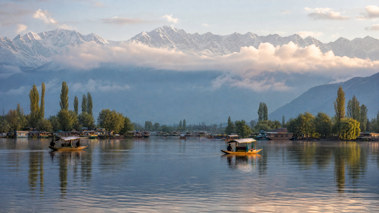
Srinagar is Jammu and Kashmir’s summer capital, set in the centre of the Kashmir Valley on the Jhelum River at roughly 1,585 metres. Its distinctive landscape is not one viewpoint but a connected urban water system: Dal Lake, adjoining waterways, houseboat neighbourhoods, old bridges and the Zabarwan foothills. Formal gardens add another historic layer, using terraces, water and mountain backdrop rather than separating culture from landscape. The city is also a strong place to approach Kashmiri handicrafts, dried fruit and everyday street life with more context than a brief lake visit allows. A flexible stay lets weather and light shape the order of outdoor visits.
Why this place matters
Choose Srinagar for the most rounded introduction to the Kashmir Valley. It combines waterborne observation, garden design, religious and civic heritage, food traditions and a walkable sense of daily life that mountain resorts cannot supply. The Jhelum’s bridges and neighbourhoods reward slow looking, while Dal Lake offers a different rhythm at dawn or late afternoon. Srinagar also reduces transfer fatigue before or after higher destinations, making it particularly useful for first visits, mixed-age groups and travellers who want culture without a difficult trail. Its appeal is depth and atmosphere rather than a single landmark, so two or three nights usually feel more satisfying than a hurried stop.
mountain meadow and winter-sports landscape · Baramulla district, Kashmir Valley
Gulmarg
Gulmarg, whose name translates as “Meadow of Flowers,” is a high mountain resort in Baramulla district, reached from the Srinagar side of the valley. Its character changes sharply by season: meadows and conifer slopes dominate the warmer months, while snow defines winter. The settlement sits beneath the Apharwat area, where the terrain becomes much more exposed and high. A cable-car route is a prominent feature, but Gulmarg is more than a lift ride; forest walks, meadow edges and changing weather give it an alpine scale. Its long history as a resort is visible in the planned open landscape and the contrast with nearby village life.
Why this place matters
Gulmarg is the clearest choice for travellers seeking a concentrated mountain experience with relatively developed facilities. Winter visitors come for snow activity and snowy scenery, while late spring through early autumn brings meadow walking, broad views and cooler air. It works well for people who want mountain drama without committing to a remote expedition, but that convenience also draws crowds at peak times. Stay overnight if possible: early and late hours show the landscape more quietly, and an extra night protects the itinerary from weather holds. The trade-off is altitude, cold, queues and rapid visibility changes, especially above the main settlement.
river valley and pastoral mountain landscape · Anantnag district, south Kashmir
Pahalgam and Aru Valley
Pahalgam is a south Kashmir valley town where river, pine forest, open pasture and mountain routes meet. The surrounding landscape is often understood through nearby side valleys rather than through the town alone; Aru, in particular, gives a more pastoral and higher-valley counterpoint. This is also a living seasonal landscape, shaped by residents, grazing and pilgrimage-linked movement, not an empty alpine park. Pahalgam’s broad appeal can make its central areas busy in the warmer months, while quieter edges and a longer stay offer a more measured experience. Terrain beyond settled areas becomes progressively rougher and more weather-sensitive, so day ambitions should match conditions and fitness.
Why this place matters
Choose Pahalgam when a trip needs river scenery, forested valleys and an easy transition toward mountain landscapes. It is especially good for travellers who prefer gentle walks and scenic pauses to high-adrenaline activity, and Aru adds a more open meadow setting without demanding a technical trek. The area’s visual variety—water, timbered slopes, grazing land and distant ridges—makes it rewarding in changing light. It also provides a useful base for understanding the human side of the valley, including its role in a major seasonal pilgrimage route. The trade-off is heavier seasonal demand and less predictability for higher excursions after rain or snow.
high mountain valley and glacier landscape · Ganderbal district, Kashmir Valley
Sonamarg and the Sind Valley
Sonamarg lies in the upper Sind Valley, where the scale shifts from Srinagar’s lakeside urbanity to a broad mountain corridor beneath snowfields and glaciers. The destination is valued for its river landscape, high pastures and the visual drama of the surrounding ranges. Nearby Gagangeer and the Thajiwas side of the valley show how quickly the terrain becomes colder, steeper and more seasonal. Sonamarg is also a gateway landscape rather than a static resort: its position on a major mountain approach gives it logistical importance but exposes it to weather and traffic constraints. Snow can remain well after the valley floor has turned green.
Why this place matters
Go to Sonamarg for a vivid encounter with Kashmir’s high-elevation edge without presenting a strenuous trek as compulsory. The Sind River, massive valley walls and seasonal snow create a sense of scale distinct from Gulmarg’s meadow resort character and Pahalgam’s forested river valley. It suits travellers who value geological drama, day walks of suitable difficulty and a slower look at a mountain corridor. An overnight visit is preferable when conditions allow, because a rushed out-and-back leaves little margin for weather or traffic. The trade-off is exposure: rain, snow, rockfall risk and temporary road restrictions can quickly remake the day’s plan.
national park and mountain wildlife habitat · Srinagar and Pulwama districts, Kashmir Valley
Dachigam National Park
Dachigam National Park is the closest major wildlife landscape to Srinagar, yet it should be approached as habitat rather than an extension of urban sightseeing. The park’s mountain forest, scrub, streams and elevational range support the endangered Hangul, or Kashmir stag, along with many other Himalayan species. Jammu and Kashmir’s wildlife authority identifies Dachigam within the protected-area network and highlights the territory’s exceptional mountain biodiversity. Wildlife activity and visibility change with season, time of day and disturbance; absence of an animal is normal. The value of a visit lies in respectful observation of a protected ecosystem and in learning why habitat continuity matters.
Why this place matters
Dachigam offers a conservation-focused counterweight to the region’s celebrated lakes and meadows. It is meaningful for visitors who want to see how a national park functions near a capital city, understand the story of Hangul conservation, and spend time in wooded mountain terrain with a guide-led, low-impact mindset. The experience can be rewarding even without a flagship sighting: birdlife, vegetation, water and the changing slopes explain the ecological setting. This is not a wildlife guarantee or a place for loud group behaviour. Visitor access, routes and timing are managed, so it is best for flexible travellers willing to follow staff direction and accept conservation priorities.
Ramsar wetland and freshwater lake · Bandipora and Sopore area, north Kashmir
Wular Lake
Wular Lake is a vast freshwater wetland north of Srinagar, lying between the Bandipora and Sopore areas. It is designated as a Ramsar site and its published site record describes extensive marshes and emergent and floating vegetation. The wetland supports fishing, irrigation, domestic water use, birdlife and livestock-linked livelihoods, which makes it a cultural landscape as much as a scenic lake. Its large surface and open horizon offer a different visual language from Dal Lake’s intimate urban waterways. Water level, bird presence and shoreline appearance are seasonal, and the most responsible visit treats local work and habitat as central rather than incidental.
Why this place matters
Visit Wular to understand Kashmir through wetland ecology and livelihoods rather than only through mountain viewpoints. Its scale can be especially compelling for birdwatchers, photographers working at a respectful distance and travellers interested in how freshwater systems sustain communities. Winter and migration periods may bring more bird activity, but nature is variable and should never be treated as a schedule. Wular also encourages a slower itinerary: pause, listen and learn what is visible from an appropriate public edge instead of forcing access to every shoreline. The trade-off is that it has fewer formal visitor facilities than headline resorts and needs more careful local orientation.
remote mountain valley and cultural landscape · Bandipora district, north Kashmir
Gurez Valley
Gurez Valley is a high, remote valley in Bandipora district, associated with the Kishanganga River, steep mountain walls, meadow country and a distinctive Shina-speaking cultural setting. Its appeal is distance from the standard Srinagar–Gulmarg–Pahalgam circuit, but remoteness is not a blank space: settlements, herding, weather and the valley’s sensitive geography shape the visit. The tourism authorities present Gurez as an alpine landscape, while its actual experience depends strongly on the season and current travel conditions. Long approach roads, finite services and a short warm-season window mean it should be given time rather than treated as a casual day trip from the capital.
Why this place matters
Gurez is for travellers seeking a quieter, more immersive mountain-valley stay where landscape and community life are inseparable. The Kishanganga corridor, timbered homes, grazing landscapes and long views create a sense of place unlike the region’s larger resorts. It rewards patient observation, short walks agreed locally and conversation that respects privacy and daily work. Choose it only if your schedule can absorb a delayed departure or altered plan; its remoteness is the attraction and the constraint. Visitors looking chiefly for dense sightseeing or fixed hour-by-hour movement will usually be better served by Srinagar or the established valley resorts.
historic spring and Mughal garden · Anantnag district, south Kashmir
Verinag Spring and Garden
Verinag is a spring-and-garden landscape in south Kashmir, revered as the source of the Jhelum. The present formal setting reflects a Mughal intervention: an octagonal stone basin and arcade commissioned under Emperor Jahangir in 1620, followed by Shah Jahan-era garden works. That combination makes Verinag unusually legible: water rises from the ground, then enters a composed architectural sequence of stone, arches, channels and vegetation. It is quieter in character than Srinagar’s larger gardens and offers an instructive connection between hydrology, imperial design and the river that organizes much of the Kashmir Valley. Its beauty rests on careful looking, not on demanding activity.
Why this place matters
Go to Verinag for a concentrated encounter with Kashmir’s spring culture and garden history. It suits travellers who enjoy architecture and landscape as one experience, and it pairs naturally with Martand or a longer south Kashmir stay. The source setting offers a valuable perspective on the Jhelum before it becomes Srinagar’s urban river. Because the site is compact, it works well as a half-day cultural pause rather than an all-day destination; lingering around the water and arcade is more rewarding than racing through. The trade-off is that it has less nightlife and fewer diversions than the main valley bases, so combine it with nearby heritage or countryside.
archaeological temple complex · Mattan area, Anantnag district, south Kashmir
Martand Sun Temple
Martand Sun Temple is a major medieval Hindu shrine near Anantnag, dedicated to Surya and generally dated to the eighth century. Its ruined stone complex remains powerful because the plan, walls and sculptural fragments show the ambition of Kashmiri temple architecture even without an intact roofline. The site also carries living religious significance for Kashmiri Pandits, so it should not be reduced to a photogenic ruin. Its open setting and elevated views help explain why architecture, ritual and landscape are inseparable here. Visit with a sense of archaeological fragility: masonry, carved surfaces and interpretation need space, patience and no climbing.
Why this place matters
Martand is essential for visitors who want Kashmir’s history to extend beyond Mughal gardens and nineteenth-century palaces. It presents an older architectural vocabulary and a layered sacred narrative in a setting that connects stonework to the wider valley. The experience is especially valuable when paired with Verinag, because one reveals a designed spring landscape and the other a monumental temple complex; together they disrupt an overly narrow picture of Kashmir. It is best for reflective travellers, architecture students and anyone willing to spend time reading form and setting rather than seeking entertainment. Uneven surfaces and exposure make it less suitable for rushed or mobility-limited visits.
archaeological temple complex and mountain trailhead · Ganderbal district, Sind Valley
Naranag Temple Complex
Naranag is a stone temple complex on the Bhuteshwara slope of the Harmukh range in the Sind Valley. Its name is associated locally with a spring, and the setting still makes water, mountain and ruins feel closely connected. The tourism description identifies it as a Buddhist architectural marvel, while the visible complex is also widely encountered as a historic temple landscape; the site merits care precisely because its chronology and meanings are layered. Naranag’s value lies in the contrast between carved masonry, valley settlement and the dramatic Harmukh backdrop. It also functions as a starting point for higher country, so a heritage visit may share space with hikers and local movement.
Why this place matters
Choose Naranag for a less crowded archaeological stop that retains an immediate mountain context. It offers a compelling alternative to city-based heritage: rather than viewing objects indoors, visitors read walls, water and slope together. The complex can anchor a day in the Sind Valley or become the cultural beginning of a carefully planned mountain walk. It particularly suits travellers interested in Kashmir’s plural historical record and in places where the landscape has not been separated from sacred architecture. The trade-off is modest visitor infrastructure and uneven terrain. Do not assume a high-country route is suitable simply because the ruins are reachable; conditions change quickly beyond the settlement.
historic city and palace complex · Jammu district, Jammu division
Jammu City and Mubarak Mandi Palace
Jammu, the winter capital, brings a warmer foothill and plains perspective to a territory often represented only by the Kashmir Valley. The city is known for a dense religious landscape across faiths and for Dogra cultural heritage. Mubarak Mandi Palace was the Dogra Maharajas’ principal residence until 1925, and its architecture combines Rajasthani and Mughal elements. The Pink Hall houses the Dogra Art Museum, noted for Hill School miniatures from Kangra, Jammu and Basholi. Taken together, city streets, shrines and palace precincts help visitors understand the historic political centre from which the wider region was once governed.
Why this place matters
Jammu is the right choice for travellers who want to broaden a Kashmir itinerary rather than merely pass through a transport hub. Mubarak Mandi gives the Dogra period an architectural focal point, while museums, temples and mixed sacred sites add texture to the city’s public life. It pairs well with Katra but deserves its own time, particularly for art, history and an urban climate that differs markedly from Srinagar. The trade-off is heat: warmer months can make midday sightseeing tiring, so morning and late-afternoon pacing matters. The palace’s museum context also makes Jammu a strong indoor cultural option when mountain weather interrupts plans elsewhere.
pilgrimage town and sacred mountain route · Reasi district, Jammu division
Katra and Shri Mata Vaishno Devi Shrine
Katra is the base town for the Shri Mata Vaishno Devi Shrine in the Trikuta Hills of Reasi district. The shrine lies about 13 kilometres from Katra and is one of India’s major Hindu pilgrimage destinations, managed by a statutory shrine board since 1986. It is best understood as a living devotional route, not a scenic hike marketed as an ordinary leisure excursion. The journey’s pace, crowd flows, weather, medical needs and religious etiquette shape the experience. Katra also sits within Jammu’s foothill geography, so it can be paired thoughtfully with Jammu city while retaining enough time for the pilgrimage on its own terms.
Why this place matters
This is a meaningful destination for pilgrims and for travellers wishing to understand the scale and organization of a major contemporary sacred landscape. The route links a base town, hill paths, service areas and the holy cave in a continuous act of worship, making respectful participation more important than speed. It can also be instructive for visitors interested in public pilgrimage management and mountain access. Choose it only if you can accommodate variable queues, physical exertion or assisted-mobility needs, and seasonal crowd controls. The trade-off is intensity: high demand and changing conditions mean an inflexible itinerary, casual behaviour or a last-minute arrival are poor fits.
Season and pace
Choose a date window for the experience, then keep a fallback.
Spring, broadly March to May, brings blossom, garden colour and reopening highland roads, though late snow or rain can alter plans. Valley summer, roughly June to August, is green and comparatively cool, but monsoon-linked rain can affect Jammu and trigger slope hazards. September and October often offer clear light and autumn colour, with cold high-elevation nights. December through March is snow-oriented: Gulmarg changes character, while upper trails, lakes and roads may close. Srinagar and Jammu receive very different annual rainfall. Treat month ranges as guides, not guarantees, and follow current warnings.
Movement and planning
Distance on a map is not the same as usable travel time.
Moving through the region
Air travel commonly anchors journeys through Srinagar or Jammu, while the Udhampur–Srinagar–Baramulla rail corridor improves the connection between them. Rail reduces dependence on the long mountain road for some journeys, but onward movement relies on roads and local transport. In Srinagar, walking, short vehicle trips and water travel serve different neighbourhoods; elsewhere, valleys, traffic controls and weather set the pace. Roads can close after rain, snow, landslides or maintenance. Build daylight buffers, avoid same-day mountain-transfer connections, and reconfirm transport locally.
Building a workable route
Use a base-and-spokes plan: three nights around Srinagar can absorb gardens, old-city texture, Dal Lake and a nearby protected area, while separate stays suit Gulmarg, Pahalgam or Sonamarg. Add Jammu and Katra when Dogra heritage or pilgrimage is central. Gurez, high lakes and trailheads need contingency. Carry layers, sun and rain protection, a refillable bottle and footwear for uneven ground. City promenades, selected gardens and shrine facilities are generally more feasible for limited mobility than steep paths, rough archaeology or upper-mountain excursions. Confirm current entry, crowd, weather, road and activity rules locally.
Travel responsibly
The regional context includes its limits.
Travel choices affect fragile mountains and wetlands. In protected areas, remain on permitted routes, keep quiet and distant from animals, never feed wildlife, and accept that sightings are never owed. Around Wular, Dal and other water bodies, avoid litter and disposable plastic; wetlands support livelihoods, fish and migratory birds. On trails, carry waste back, do not shortcut turf, and do not collect plants, stones or artefacts. At shrines and temples, dress and behave respectfully, follow photography guidance and yield space during worship or crowd control. Be careful sharing locations near sensitive terrain. Revise plans when weather, conservation staff or civil authorities advise restraint.
This is an evergreen regional guide. Weather, permits, closures, transport and local rules can change; confirm material conditions through the relevant local or official channel before travel.