North India · State · HP
Himachal Pradesh
Himachal Pradesh is a mountain state of sharp contrasts: subtropical Shivalik foothills, cedar valleys, orchard country, historic hill towns, trans-Himalayan cold desert and high glacial catchments. Shimla provides the civic and rail heritage entry point; Kangra and Chamba reward slower cultural travel; Kullu, Kinnaur and Lahaul–Spiti require more time and flexibility. The Sutlej, Beas, Ravi and Parbati link landscapes that otherwise feel distinct. Travel decisions should begin with altitude, season and road resilience rather than a checklist. Spring and autumn often balance visibility and access in the middle hills, while winter birding at Pong and summer in the high valleys follow different calendars. Mountain weather, snow, rainfall, landslides and maintenance can change plans quickly. This selection is a considered introduction, not a complete inventory of the state’s places. It is best experienced through one or two carefully chosen valleys, with room to pause, walk, and revise plans responsibly.
Regional notebook
Begin with the shape of the region.
Himachal Pradesh rewards a valley-by-valley approach. A short journey can connect Shimla’s built heritage with Kangra’s temples and Dharamshala’s Tibetan cultural life; a longer one can add Kullu’s river valleys or the dry, high plateaux of Kinnaur and Spiti. The appeal is not only snow views: it is working orchards, local deities, monasteries, historic trade corridors and protected forests. Distances look modest but switchbacks, weather and elevation make travel slow. Choose one coherent arc rather than treating the state as a drive-through. The most dramatic high country asks for more days, acclimatisation and tolerance for disruption; lower and middle hills offer fuller services and more flexible year-round choices.
Landscape
Geography changes the journey.
The state spans roughly 350 to 6,975 metres, from low foothills to high Himalayan terrain. Its Sutlej, Beas, Ravi and Parbati catchments contain reservoirs, conifer belts, meadows and cold-desert basins. A warm day in lower Kangra can coincide with snow-bound passes elsewhere. The Dhauladhar rises abruptly above Kangra; Kullu and Parbati are wetter mountain landscapes; Kinnaur follows the Sutlej into drier high country; Spiti is a rain-shadow mountain desert. Do not assume a statewide forecast describes a particular valley. Altitude, aspect and the condition of one road or pass often matter more than straight-line distance.
Living culture
Arrive as a guest, not an audience.
Himachal’s culture is plural and strongly local. Hindu temple traditions and village-deity systems shape many valleys, while Buddhist monastic life is central in trans-Himalayan districts. Kangra painting, Chamba rumals, wood-and-stone building practices and seasonal fairs make this cultural landscape visible beyond museums. Hindi is widely used, but local speech changes quickly: Kangri is associated with the Kangra Valley, Kullui and Mandeali are heard farther east, and Kinnauri and Bhoti-related varieties reflect highland communities. Temples, monasteries and village spaces are active religious and social settings. Ask before photographing people or ritual activity, dress modestly, and follow directions about footwear, quiet areas and offerings.
Curated regional atlas
Places that reveal different parts of Himachal Pradesh
This is a selective, geographically varied starting point rather than an exhaustive list. Use it to choose a coherent route, not to compress every place into one trip.
historic hill city and mountain railway · Shimla district; rail approach through Solan district
Shimla and the Kalka–Shimla Railway
Shimla is Himachal Pradesh’s administrative capital, a hill city whose ridges, civic buildings and pedestrian stretches layer colonial-era planning with everyday mountain life. Its distinctive approach is the Kalka–Shimla Railway, a narrow-gauge working line within the Mountain Railways of India World Heritage property. The route climbs through tunnels, bridges and sharp curves to Shimla. In town, heritage walks work best as an exploration of topography, public buildings and local life rather than a rushed photo circuit. Railway and city together offer an accessible introduction to how mountain mobility shaped settlement.
Why this place matters
Choose Shimla for architectural texture, walkable stretches and mountain-transport history. The rail journey makes the gradient tangible: engineering, forested slopes and villages unfold at a scale road travel often erases. It is a useful counterpoint to wilder parts of the state and suits visitors interested in railways, built heritage or mountain urbanism. Peak holidays bring crowds, and central terrain is steep. Allow time beyond the main promenade and treat rail timing as flexible rather than using the journey as a tight same-day transfer.
mountain town and Tibetan cultural landscape · Kangra district
Dharamshala and McLeod Ganj
Dharamshala spreads across the lower Dhauladhar foothills, while McLeod Ganj sits higher at about 2,082 metres. The area is known for its Tibetan community and institutions connected with Tibetan life in exile, alongside older hill-station traces and Kangra’s cultural setting. Mountain slopes rise abruptly behind the town. It is not a sealed enclave: Tibetan, Himachali and visitor economies meet in an active settlement. Use the area to learn through respectful observation, museums or public cultural spaces, and leave time for the lower town rather than treating McLeod Ganj as the whole destination.
Why this place matters
This is the state’s clearest introduction to a living Tibetan cultural landscape without immediately entering remote high country. Its mix of monasteries, public institutions, forest edges and mountain views sustains an unhurried stay, while Kangra’s temples and forts lie within reach. Compact streets can be busy and steep, especially in high season, and weather closes in quickly against the Dhauladhar. Respect quiet spaces and do not assume religious institutions are open to unscheduled access or photography. Its position also makes it a sensible starting point for lower-elevation Kangra exploration before committing to more remote valleys.
historic fortress · Kangra, Kangra district
Kangra Fort
Kangra Fort occupies a strategic ridge in the Kangra Valley and is associated with the long history of the Katoch dynasty. Its gateways, walls and ruined precincts read as a topographical fortress rather than a fully intact palace. The 1905 earthquake damaged structures across the region, an important lens for its present condition. Views over the valley explain why the location mattered, while museum displays and stone remains introduce the area’s political and artistic worlds. Combine it with Kangra town or Masroor, allowing time to move carefully through uneven historic fabric.
Why this place matters
Go to read power, geology and loss in one place. Kangra Fort’s ridge position, layered construction and earthquake-marked ruins offer a different heritage experience from Shimla’s civic architecture or Chamba’s active temples. It suits travellers interested in fortifications, regional dynasties and Himalayan conservation. Morning and later afternoon can make contours easier to appreciate, though quiet is not assured. Uneven steps and exposed sections can challenge visitors with limited mobility, especially after rain. It is best approached with sturdy footwear and enough time to interpret the site rather than simply collect a panorama.
rock-cut temple complex · Masroor, Kangra district
Masroor Rock-Cut Temples
Masroor is an early medieval complex of monolithic rock-cut Hindu temples in the Kangra Valley, facing the Dhauladhar. Its clustered shrines, shikharas, sacred tank and square-grid arrangement make it an exceptional northern Indian example of rock-cut Nagara architecture. The complex references Shiva, Vishnu, Devi and Saura traditions, while incomplete entrances remain visible in stone. Earthquake damage and lost sculpture are part of its story, not reasons to imagine a pristine reconstruction. The setting is quieter than large city monuments, but its scale and carved geometry reward unhurried looking.
Why this place matters
Masroor offers a concentrated encounter with Himalayan temple architecture that is both monumental and fragile. Unfinished elements and seismic damage make craft, time and preservation visible together. It suits travellers who value archaeology, sacred architecture and landscape, and pairs well with Kangra Fort’s defensive stonework. The complex lies outside the most convenient urban loop and needs a dedicated half day or more. Treat the pool, carvings and sanctums with care: living worship and conservation come before close-up content creation. Its location also makes a quieter, more considered alternative to the faster rhythm of nearby hill-town sightseeing.
historic temple town and craft centre · Chamba district
Chamba Town
Chamba is a historic hill town around the broad Chowgan and Ravi valley, shaped by a former princely state, temple patronage and fine arts. The Laxmi Narayan complex, begun in the tenth century, adapts shikhara forms with wooden roof elements suited to snowfall. The Bhuri Singh Museum adds paintings, inscriptions, costumes, jewellery and Chamba rumals, while the Chowgan remains a civic space associated with the Minjar fair. Chamba’s value is the relationship between active worship, public ground, craft memory and mountain urban form rather than one headline sight.
Why this place matters
Choose Chamba for a heritage stay where temple architecture, museum collections and living public landscape reinforce one another. It rewards interest in Pahari painting, embroidery, festivals and climate-shaped building. The Chowgan offers breathing room, and the temple complex repays repeat visits. Chamba is not an effortless add-on to Kangra or Shimla, so it deserves at least an overnight stay. Respect worship patterns and remember that fair dates, museum access and public-space use can change. For many travellers, this slower rhythm is precisely the advantage over a rapid, place-collecting mountain itinerary.
mountain town and river valley · Kullu district
Manali and the Upper Kullu Valley
Manali sits near the upper Kullu Valley, where the Beas, orchards, forests and snow-lined slopes meet a long route toward Lahaul, Ladakh and Spiti. The town is associated with the Manu tradition; nearby Vashisht and Naggar add springs, temples, former-capital history and valley views. Kullu district’s cultural landscape includes deity traditions and Dussehra centred on Raghunath at Kullu town. Manali is therefore more than a high-season resort: it is a gateway to multiple Himalayan ecologies and routes. Its popularity makes thoughtful timing and a slower base essential.
Why this place matters
Go for a versatile mountain base where forests, river landscapes, village architecture and high-country access converge. It suits first-time Himalayan travellers wanting services and day-scale variety, and repeat visitors learning Kullu’s deity culture and trade connections. Naggar offers a historical counterpoint to busier Manali. Peak demand strains roads and public space. Do not build an itinerary around a pass crossing without contingency, and do not assume Manali’s conditions apply farther north. Give the valley time instead of trying to add several remote side trips in one crowded day.
protected mountain landscape · Kullu district
Great Himalayan National Park Conservation Area
The Great Himalayan National Park Conservation Area protects a western Himalayan mosaic of riverine forest, conifer and broadleaf belts, alpine meadows and peaks above 6,000 metres. It contains the Jiwa Nal, Sainj, Tirthan and Parvati headwaters feeding the Beas basin, and ranges from below 2,000 metres to high alpine terrain. World Heritage recognition rests on biodiversity: 25 forest types and habitat for threatened fauna and plants. This is not a theme-park wilderness but a regulated conservation landscape whose integrity is tied to careful access, surrounding communities and long walking approaches.
Why this place matters
Choose this area for ecological depth, not instant viewpoints. The reward is a journey through forest and meadow habitats, an understanding of Himalayan headwaters and low-impact nature travel. It suits prepared walkers and birders willing to exchange dense itineraries for days in one valley. High biodiversity and close regulation are inseparable: wildlife cannot be promised and routes should not be improvised. Time, weather and physical demands are meaningful trade-offs. Follow designated arrangements and treat habitat limits as the reason the landscape endures.
trans-Himalayan valley and monastic landscape · Spiti subdivision, Lahaul and Spiti district
Spiti Valley and Key Monastery
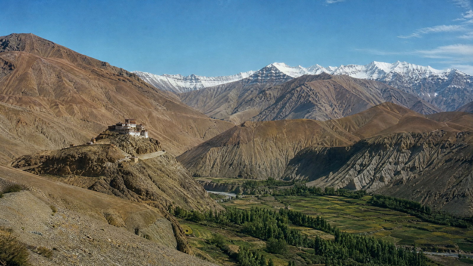
Spiti is a high cold desert enclosed by ranges and shaped by the Spiti River before it joins the Sutlej. The district describes an average valley-floor elevation around 4,270 metres and low annual rainfall, very different from Kullu or Kangra. Key Monastery, above the valley near Kaza, is a defining landmark within a wider Buddhist landscape of villages, fields and monasteries. Sparse terrain can create a false sense of ease: sunlight is strong, nights are cold and altitude is real. Spiti merits a paced visit rather than a rapid driving circuit.
Why this place matters
This is Himachal’s sharpest geographic and cultural contrast: an austere trans-Himalayan basin where Buddhist monastic life, irrigated settlement and giant erosional forms coexist. It suits travellers prepared to acclimatise, accept simple logistics and change plans when roads require it. The reward is perspective rather than activity volume. Altitude can affect anyone, facilities thin out away from Kaza and some foreign visitors face protected-area requirements at listed locations. Seek local health advice if symptoms persist or worsen. Build in an extra buffer day so that safety and acclimatisation remain more important than a fixed checklist.
high-altitude alpine lake · Lahaul and Spiti district
Chandra Taal
Chandra Taal is a high-altitude lake in the Lahaul–Spiti environment, reached through terrain governed by short seasons, snow and exposure. Open highland forms, distant glaciers and intense light replace the dense forests of lower Himachal. It belongs in an itinerary as a fragile mountain ecosystem, not merely a roadside scene. The lake lies near the Kunzum Pass approach in a district where conditions shift rapidly. Plan around acclimatisation, conservative walking and the possibility that access or camping arrangements change with weather and conservation management.
Why this place matters
Go for an elemental high-Himalayan landscape that reveals the scale and aridity of Lahaul–Spiti. Chandra Taal is most meaningful after time in Spiti because it makes altitude, water and seasonal access visible. It suits low-impact lake travel rather than developed recreation. Cold, wind, uneven ground and altitude can make a short walk demanding, while weather can close the approach. Do not rush in from low elevation, leave no trace and do not assume access because it is summer elsewhere. Carry adequate water and warm layers, and be ready to retreat if weather, fatigue or breathing comfort deteriorate.
heritage village and high-mountain cultural landscape · Kinnaur district
Kalpa and Kinner Kailash
Kalpa is a heritage village above the Sutlej corridor at about 2,759 metres, looking toward Kinner Kailash. Its position on the old Hindustan–Tibet Road gives it historic-route context, while local temples and Buddhist monasteries show the meeting of mountain traditions. The Narayan-Nagani temple is noted for local craftsmanship, and early light on the massif is a defining experience. Near Reckong Peo, Kalpa functions as a quieter, steeper base oriented toward orchards, roofs and mountain views. It introduces Kinnaur’s transition from greener middle Himalaya to drier high country.
Why this place matters
Kalpa rewards travellers who want cultural landscape as much as spectacle. It brings together route history, wood-and-stone craft, Hindu and Buddhist presences, orchard economy and the changing face of Kinner Kailash. It is a strong alternative to rushing toward more distant valleys, providing time to adjust and observe. Kinnaur remains mountain-road travel: delays, rockfall risk and a long approach can reshape plans. Use a two-night pause where possible, respect sacred sites and learn about the village as well as its view.
highland valley and village landscape · Kinnaur district
Sangla, Chitkul and the Baspa Valley
The Baspa Valley combines river, cultivated slopes, conifer forest and high peaks in one of Kinnaur’s most recognisable inhabited landscapes. Sangla sits at about 2,621 metres on the Baspa’s right bank, while Chitkul, around 3,450 metres, is the valley’s last and highest village. Houses climb slopes, and Chitkul’s local goddess temples express continuing religious life. This is not a wilderness void: farms, roads, homes and sacred sites are integral to its appeal. The journey from Karcham is part of the experience and a reminder that dramatic valleys depend on exposed roads.
Why this place matters
Choose the Baspa Valley for a more intimate highland landscape than Spiti’s broad dry grandeur. Village life, fields, river sound, forest texture and snow peaks suit slow walking and observation. Sangla offers a base, while Chitkul marks a higher, colder settlement environment. Road conditions can change, weather narrows visibility and high-season demand strains the small valley. A two- or three-night stay reduces pressure to hurry. Stay on public paths, ask before entering fields or photographing homes, and respect directions around temples and water.
reservoir wetland and bird sanctuary · Kangra district
Pong Dam Lake Wildlife Sanctuary
Pong Dam Lake, also called Maharana Pratap Sagar, is a large Beas reservoir in the Shivalik foothills and an internationally important wetland. Its open water, marshy edges and village landscape support major seasonal bird concentrations, notably bar-headed geese. District records identify more than 420 bird species across 56 families and winter as the prime birding period. This lower-elevation wetland broadens the idea of Himachal beyond peaks and passes: water levels, migration and reservoir ecology are the story. Nagrota Surian is a key bird-sanctuary area, with views and recreation spread around the lake.
Why this place matters
Pong is one of the state’s strongest choices for patient wildlife observation, especially when high passes are cold or inaccessible. It suits birders, families and travellers seeking a gentler landscape after mountain travel. Watch quietly from appropriate public viewpoints and give the wetland time rather than chase sightings. Bird concentrations, water levels, boating and paths vary seasonally. Wildlife sets the terms, so no species should be expected on cue. Avoid drones, loud sound and close approach, and carry litter away from the shore.
sacred lake and wildlife sanctuary · Sirmaur district
Renuka Lake and Wildlife Sanctuary
Renuka is a lower-elevation cultural and ecological counterpoint to Himachal’s alpine destinations. The sanctuary in Sirmaur covers Renuka Reserve Forest around the lake and has a contiguous buffer belt. Renuka Lake is closely linked with the worship of Renukaji and Parshuram, making the landscape a religious destination and habitat. Its forests include dry mixed deciduous and dry sal types, with birds and mammals recorded by district administration. The lake’s sacred narrative gives it a rhythm unlike a recreation-only waterbody: temples, pilgrims, forest boundaries and quiet observation coexist.
Why this place matters
Visit Renuka for a compact introduction to lower Himalayan ecology and sacred geography. The lake and forest contrast with Pong’s broad reservoir and Lahaul–Spiti’s cold-desert lakes. It suits interest in Hindu pilgrimage landscapes, birdwatching and dry-forest ecology, particularly when high routes are snowbound. Religious, conservation and visitor functions overlap, so expectations should remain flexible. Observe temple customs, keep distance from animals and do not enter restricted forest. A quiet lake circuit is more meaningful than treating the site as a high-adrenaline outing.
Season and pace
Choose a date window for the experience, then keep a fallback.
March to June usually brings milder middle-hill conditions, blossom and green slopes, but lower valleys can become hot before the monsoon. July to September makes many high-altitude routes viable, yet rain can bring landslides, swollen streams and service interruptions. October and November often offer clearer light, cooler nights and harvest texture. Winter transforms the map: Pong becomes compelling for migratory birds, middle hills are crisp, and high valleys may face severe cold, snow and limited mobility. Lahaul–Spiti is drier than monsoon-facing valleys but altitude risk remains. Treat seasonal ranges as planning guides, then confirm current forecasts and road status.
Movement and planning
Distance on a map is not the same as usable travel time.
Moving through the region
Most regional travel is by road, so include buffers for slow climbs, congestion and weather-related holds. The Kalka–Shimla railway is a heritage journey as well as transport, but its timing can change and it should not be the only connection in a tight plan. Main towns have wider options; last-mile access to villages, temples and wetlands can be sparse. Roads to Kinnaur, Lahaul and Spiti pass through exposed terrain and require daylight, an unhurried itinerary and fuel, water and cash margin. High passes and lake approaches are seasonal. Some border-area locations in Lahaul–Spiti have protected-area rules for foreign visitors; confirm eligibility and documents before booking travel.
Building a workable route
Build the trip around elevation bands. Shimla, Kangra, Chamba, Pong and Renuka suit lower or middle-elevation cultural and nature stops. Manali and the Great Himalayan National Park need more time; Kinnaur and Spiti deserve separate slow circuits. Rest after a large altitude gain and avoid demanding walks on arrival in high country. Carry layers, rain and sun protection, a refillable bottle, basic offline navigation and needed medicines. Heritage cores may have steps and uneven stone; mountain paths can be unsuitable for wheels or unsteady walkers. Confirm hours, rail services, local transport, seasonal access and permissions through the relevant official or local channel near departure.
Travel responsibly
The regional context includes its limits.
Water, slopes and sacred spaces are shared resources, not scenery to consume. Refill rather than rely on disposable bottles, keep waste where collection is limited, and use water and electricity carefully in dry settlements. Stay on marked paths; do not approach wildlife, feed birds, enter closed areas or use loud sound near monasteries, temples and nesting habitat. At Pong, give birds feeding and resting space. In the Great Himalayan National Park conservation landscape, follow current rules rather than improvising routes. Do not stop on blind bends, cross barriers or press onward during alerts. Support locally made crafts through transparent purchases, but avoid treating residents, worship or traditional dress as props. Revise plans when official weather or road guidance changes.
This is an evergreen regional guide. Weather, permits, closures, transport and local rules can change; confirm material conditions through the relevant local or official channel before travel.