West India · State · GA
Goa
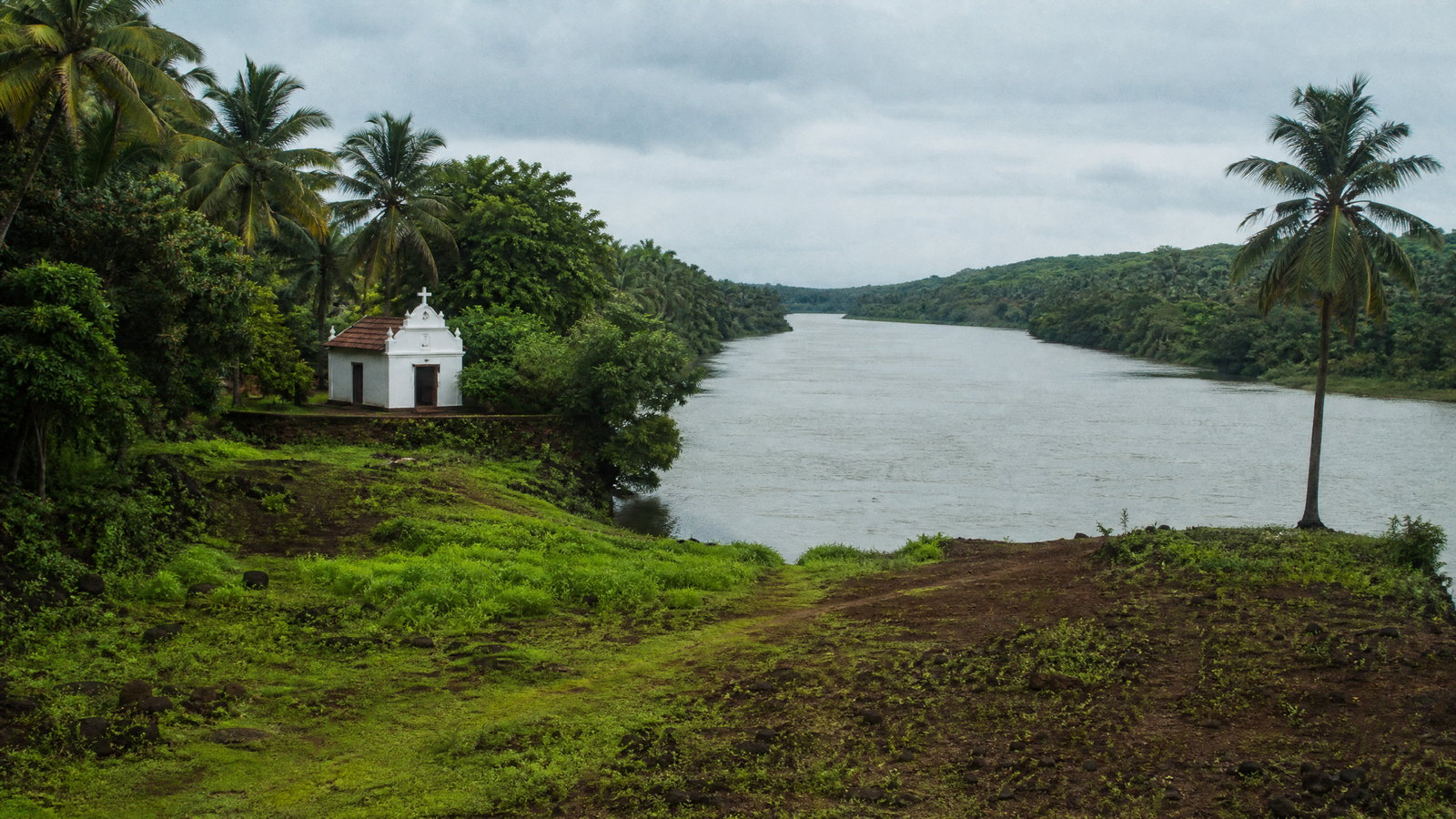
Goa is India’s smallest state by area, yet its short Arabian Sea frontage, tidal rivers and forested Western Ghats create sharply different journeys in a compact region. Panaji and Old Goa reveal a riverine capital and a major sacred and architectural ensemble; Ponda’s temples and Divar’s fields show living village landscapes; the east turns quickly toward evergreen corridors, waterfalls and protected forest. The coast offers both animated headlands and quieter nesting beaches, with seasonal sea conditions shaping what is sensible. A rewarding first visit usually combines two or three zones rather than attempting every beach and reserve. Build time for slow travel, religious etiquette and weather disruption. Goa is not only a coastal holiday setting: it is a Konkani-speaking state whose Hindu, Christian and Muslim traditions, Indo-Portuguese built forms, rice fields, mangroves and wildlife habitats remain closely linked to everyday life. Panaji is the administrative capital.
Regional notebook
Begin with the shape of the region.
Goa rewards an itinerary built around landscapes rather than a single coast. Sandy shores, laterite headlands and estuaries occupy the west; Mandovi and Zuari river settlements, paddy fields and old villages shape the centre; the east rises into protected Western Ghats forest. Panaji is the riverine capital, Old Goa lies upriver, and Ponda and Margao are useful cultural anchors.
Pair one heritage cluster with one ecological landscape and one coast. Panaji–Old Goa–Divar is a low-mileage circuit; Ponda–Tambdi Surla–Mollem is an inland arc; Canacona and Cotigao form a southern cluster. A short distance can conceal major changes in road character, tide, rain exposure, crowd level and walking surface. This record is orientation, not a promise of access; confirm current local or official information before committing to a route.
Landscape
Geography changes the journey.
Goa covers about 3,702 square kilometres on India’s west coast. The Terekhol River marks much of its northern edge, Karnataka borders the east and south, and the Arabian Sea lies west. Coastal sand and lateritic plateaux give way through tidal estuaries to the forested western flank of the Deccan plateau. Mandovi and Zuari systems shape settlement, agriculture, ferry links and islands.
Compact size does not mean easy terrain. Coastal and central corridors are settled, while the east and far south are more wooded and slower after rain. Humid heat, monsoon downpours, flood-prone low points and changing sea conditions are practical limits. Protected areas contain mangrove, moist-deciduous, semi-evergreen and evergreen habitats. Stay on authorized paths, avoid river crossings after heavy rain and follow forest instructions.
Living culture
Arrive as a guest, not an audience.
Konkani is Goa’s official language in the Devanagari script; Marathi is also used for official purposes, while English and Hindi are widely useful to visitors. Goa’s identity draws on Konkan and Deccan connections, centuries of Portuguese rule, liberation in 1961 and coastal trade. Catholic churches and Indo-Portuguese houses stand alongside Hindu temples, local deities, mosques, village commons and agricultural calendars.
Old Goa’s churches adapt European styles using local materials; Ponda’s temples reveal another sacred geography; Divar’s fields and sluice gates join water management to settlement. These are living settings, not scenery. Dress modestly, give worshippers space and ask before photographing people, homes, artisans or rituals. Festival schedules and access arrangements may shift yearly, so confirm changing details through the relevant local or official channel.
Curated regional atlas
Places that reveal different parts of Goa
This is a selective, geographically varied starting point rather than an exhaustive list. Use it to choose a coherent route, not to compress every place into one trip.
Capital city and heritage quarter · Panaji, North Goa
Panaji and Fontainhas
Panaji sits on the Mandovi’s south bank and provides Goa’s most walkable urban introduction. Its riverfront, civic core and Fontainhas heritage lanes connect a working capital with layered architectural history. In Fontainhas, tiled roofs, balconies, shrines, drainage channels and tropical planting reveal how climate and building traditions shaped a dense quarter. Homes, worship and daily services continue here, so the experience is residential rather than museum-like. Add the waterfront, a museum or market area, then allow time for unhurried observation of laterite, plaster and the small public spaces between lanes.
Why this place matters
Choose Panaji for architecture, urban texture and a low-mileage beginning before remote coast or forest. Fontainhas works best in morning or late afternoon, when heat eases and residential lanes are quieter. It is a practical base for Old Goa, Divar and Chorao, making it especially useful on a short itinerary. The trade-off is physical: narrow streets, shifting traffic patterns and uneven pavements reward walking but can frustrate hurried driving or fully step-free exploration. Treat the quarter as a lived neighbourhood, not a photographic set.
World Heritage religious and architectural ensemble · Old Goa, Tiswadi
Old Goa: Churches and Convents
Old Goa holds the major surviving monuments of the former capital of Portuguese India, now a World Heritage ensemble. Basilica of Bom Jesus, Sé Cathedral, St Francis of Assisi, St Catherine, Our Lady of the Rosary, St Cajetan and St Augustine ruins demonstrate an exceptional concentration of sacred architecture. Manueline, Mannerist and Baroque forms were adapted through local materials and conditions, creating an Indo-Portuguese language. The precinct remains a religious landscape: services, commemorations and pilgrim activity are part of its meaning, not interruptions to a monument visit.
Why this place matters
This is Goa’s key heritage anchor for architecture, Christianity in Asia, conservation and layered history. A slow half-day reveals differences among church scale, ornament, ruins and open grounds better than a rushed circuit. Go early for cooler walking and quieter light. The main trade-off is crowding around observances, when spiritual use should take priority over sightseeing. Some interiors or zones can be restricted during services, conservation work or ceremonial periods. Visitors interested in more than façades will find the greatest reward in patient looking and respectful conduct.
River island and living cultural landscape · Mandovi River, Tiswadi
Divar Island
Divar is a settled Mandovi river island reached through everyday ferry connections. Its villages retain a rural rhythm of fields, church precincts, temple traces, tiled homes and tidal infrastructure. Old sluice gates show how water control, cultivation and settlement have long been linked. Ruins associated with Saptakoteshwar, the Church of Our Lady of Compassion and smaller shrines invite a layered visit without separating heritage from landscape. The appeal is a gentle sequence of lanes, elevated viewpoints, wetlands and village edges, not a checklist of formal monuments.
Why this place matters
Go to Divar for a quiet river landscape close to Panaji and Old Goa. It suits travellers interested in agriculture, vernacular architecture and tidal environments. Ferry arrival naturally slows the pace and distinguishes the island from the main road network. The trade-off is limited formal interpretation and a visit based on respectful self-guided observation. Ferries, weather, flooding at low points and local event traffic can alter the day. Leave the schedule loose and enjoy the crossing as working transport rather than a fixed excursion.
Living pilgrimage and temple district · Ponda taluka, central Goa
Ponda Temple Landscape
Ponda’s temple belt broadens Goa beyond church architecture. Shrines such as Shantadurga at Kavalem and Mangeshi are active worship places, recognized for towers, lamp pillars, courtyards and tiled-roof forms rooted in local building traditions. Shantadurga is associated with a deity understood as a mediator of peace. Together, these sites show how faith, family pilgrimage and village economy meet in central Goa. Visit for sacred practice and architectural detail rather than speed. The surrounding countryside makes Ponda a useful link in an inland day toward Tambdi Surla or Mollem.
Why this place matters
Choose Ponda for a living Hindu sacred landscape and a fuller understanding of Goa’s cultural plurality. It suits visitors who value ritual atmosphere, regional architecture and a slower central-Goa route. Early morning or quieter daytime periods are more comfortable than peak heat. The trade-off is that etiquette matters: entry, clothing, footwear, photography and queues can differ by shrine or festival. Temple visits are most rewarding when allowed to unfold at the pace of worship instead of becoming brief photo stops. Be observant, modest and prepared to adapt.
Historic forest temple · Dharbandora, eastern Goa
Tambdi Surla Mahadev Temple
Tambdi Surla Mahadev Temple stands in wooded eastern Goa and is valued as a rare surviving early stone temple. Its compact plan and finely carved basalt elements contrast with larger later temple precincts and coastal churches. Stream, canopy, humidity and laterite roads frame a site where history and ecology are inseparable. Its Kadamba-era association makes it an important pre-colonial reference point, while ongoing religious use calls for more restraint than at a purely archaeological ruin. The temple rewards close attention to carving, roof form and its relationship with forest.
Why this place matters
Go for an intimate encounter with early Goan sacred architecture in a genuinely inland setting. It combines naturally with Ponda or Mollem but deserves an unhurried stop. The road journey and woodland edge are part of the appeal, but make it less convenient than central temples. Monsoon can make the approach wet and slippery, and heavy rain can alter rural road conditions. It suits travellers comfortable with a low-facility setting rather than a polished monument circuit. Respectful observation, not a quick landmark stop, gives the place its value.
National park, wildlife sanctuary and waterfall landscape · Dharbandora and Sanguem, eastern Goa
Mollem and Dudhsagar Falls
Bhagwan Mahavir National Park and its surrounding wildlife sanctuary form Goa’s largest protected forest landscape along the Karnataka border. Mollem’s streams, escarpments and mixed forest contain Dudhsagar Falls, Tambdi Surla and other nature features. The falls are dramatic in wet conditions, but the broader value is a Western Ghats corridor with diverse plant and animal life. Treat Dudhsagar as a managed forest visit, not an unrestricted swimming or rail-side excursion. Conservation controls, weather and operating decisions are central to a safe experience in this landscape.
Why this place matters
Choose Mollem for Goa’s strongest single introduction to inland forest scale and waterfall scenery. It suits travellers who can start early, allow a full day and value ecology alongside a photographic landmark. Dry months generally simplify road movement; monsoon increases flow and greenery but also rain hazards and access changes. The key trade-off is uncertainty: route format, vehicle controls, guide arrangements, daily limits and closures can change. Keep Dudhsagar a flexible objective rather than a guaranteed outcome, and the day will be safer and more satisfying.
Western Ghats wildlife sanctuary and watershed · Sanguem, south-eastern Goa
Netravali Wildlife Sanctuary
Netravali Wildlife Sanctuary protects a large south-eastern Western Ghats corridor of moist-deciduous forest mixed with evergreen and semi-evergreen habitat. The Netravali, an important tributary of the Zuari, rises here, making the sanctuary important for wildlife and downstream water systems. Its character is forest depth, village margins, streams and seasonal change, not a single landmark. It shows why Goa cannot be reduced to shorelines: the interior protects biodiversity, watershed functions and a different travel rhythm. Wildlife encounters are possible but should never be expected or pursued closely.
Why this place matters
Visit Netravali for a quiet landscape-scale encounter with the Western Ghats and a conservation-led day. It rewards patient observers interested in plants, birds, water and forest ambience. The trade-off is less predictable infrastructure and greater reliance on current local guidance. Rain can make paths, stream crossings and rural roads difficult; dry heat can tax exposed approaches. This is not a place for improvised off-trail movement. Let authorized access, local conditions and habitat protection determine the day’s scope, and accept observation rather than a guaranteed wildlife spectacle.
Mangrove bird sanctuary · Chorao Island, Tiswadi
Dr Salim Ali Bird Sanctuary
Dr Salim Ali Bird Sanctuary occupies estuarine mangroves on Chorao’s western tip along the Mandovi. Though small, it gives a concentrated lesson in tidal ecology: mudflats, narrow channels, roots, crabs, fish and resident or migratory birds occupy habitat far from the open beach. Named for the Indian ornithologist Salim Ali, it complements Divar and Old Goa. Quiet observation from appropriate routes or authorized boat movement can reveal egrets, herons, kingfishers, raptors and other wetland life, although species and visibility change with tide, season and disturbance.
Why this place matters
This is the strongest near-Panaji choice for understanding river ecology without a long inland drive. It rewards early, patient visits and shifts attention from landmark collecting to tide, light and habitat. Winter can bring a stronger migratory-bird dimension, but no species is assured. The trade-off is that tide governs viewing and boat movement. Mud, humidity, insects and narrow access points are part of the setting. It is not a controlled wildlife display; that unpredictability is precisely its value. Bring patience and leave bird behaviour undisturbed.
Wildlife sanctuary and southern forest · Canacona, South Goa
Cotigao Wildlife Sanctuary
Cotigao Wildlife Sanctuary protects an 86-square-kilometre southern Goa woodland near the Karnataka border. Created to safeguard an exposed forest belt, it is a remote counterpoint to central Goa and the northern coast. The attraction is layered forest: tall trees, shaded paths, bird calls and the possibility of wildlife observation without separating animals from habitat. Sightings are uncertain and should not be forced. Cotigao fits within a Canacona itinerary that also includes quieter beaches, but it requires a deliberate shift from coastal leisure to responsible forest travel.
Why this place matters
Choose Cotigao for a southern wildlife experience with a sense of forest continuity. It adds environmental depth to a coastal trip and works best early, when conditions are cooler and observation is quieter. The trade-off is distance from Panaji and the need for dedicated road time. Monsoon rain can affect paths and visibility; dry-season warmth can be strenuous. A calm, low-impact visit is more appropriate than a search for close animal contact. Plan enough time to let habitat, weather and local instructions set the rhythm.
Historic coastal fort and laterite headland · Bardez, North Goa
Chapora Fort and Vagator Headland
Chapora Fort occupies a laterite ridge above the Chapora River mouth and Vagator’s coastal curves. Its surviving walls and open interior are less about intact rooms than strategic position: river, estuary, headland and sea become immediately legible. The site has passed through changing regional powers and later Portuguese rebuilding, while the broad view explains why the ridge mattered. Combine it with attentive observation of the headland rather than treating it only as a sunset platform. The fort offers a clear introduction to Goa’s northern coastal geology and defensive geography.
Why this place matters
Go for coastal views, laterite architecture and a compact historical stop near north Goa’s beach belt. It suits travellers who want topography rather than a furnished fort experience. Morning is cooler and calmer; later heat and crowds can rise. The trade-off is exposure: steps, uneven stone, steep edges and little shade make the site demanding and unsuitable for some visitors. Conservation conditions can change, so treat it as a flexible outdoor visit. Stable footwear, time and attention to weather make the experience much better.
Historic fort and southern coastal promontory · Canacona, South Goa
Cabo de Rama Fort and Coast
Cabo de Rama is a large southern promontory where fort walls, a chapel setting, laterite slopes and the Arabian Sea meet. Local tradition associates it with the Ramayana, while visible fortifications reflect later strategic use and changing political control. Its importance comes as much from landscape as masonry: high ground reveals the southern coast’s broken, green-edged profile. The fort provides a historical counterpoint to nearby beaches for visitors willing to accept a more exposed, less polished setting. Approach it with the care appropriate to a weathered coastal monument.
Why this place matters
Choose Cabo de Rama for a southern alternative to northern headlands and for a view of fortification meeting coastline. It works with Canacona or Agonda but needs real road-time allowance from Panaji. Early or late light softens heat and clarifies cliffs and sea. The trade-off is accessibility: terrain can be irregular, walls and edges exposed, and weather can change comfort quickly. Visitors seeking a historic landscape, wind and broad coastal scale will be rewarded; those seeking swimming or nightlife should choose a different kind of stop.
Protected nesting beach and river mouth · Canacona, South Goa
Galgibaga Turtle Coast
Galgibaga is a southern beach where the Galgibag River meets the Arabian Sea, creating broad sand, palms and a protected Olive Ridley turtle nesting area at its northern end. It is one of Goa’s important nesting shores, and its quiet character is inseparable from ecological responsibility. The river mouth, vegetation and long sand differ from heavily built beach strips. Visit for a low-key coastal walk and a sense of river meeting sea, understanding that conservation places clear limits on visitor behaviour. The sea can be rough, so visual appreciation should not become casual water risk.
Why this place matters
Go to Galgibaga for a southern coast experience where habitat protection is central. It suits travellers who value open landscape, birdlife potential and a less built shoreline, especially with Cotigao or Cabo de Rama. Winter usually offers comfortable beach weather, although seasonal nesting protection may shape walking or lighting. The trade-off is deliberate restraint: do not expect intensive facilities or unrestricted beach access. Rough water, tides and conservation measures are reasons to slow down, not problems to bypass. Respect every marked habitat boundary.
Season and pace
Choose a date window for the experience, then keep a fallback.
November through February is usually the most comfortable period for walking, birding and coastal drives, although popular shores and major heritage precincts are busiest. March to May is hotter and more humid; schedule exposed heritage walks early, carry water and do not assume every beach is safe for swimming. Local wind, tide and safety flags matter more than a calendar.
The southwest monsoon generally runs from June through September, bringing lush forest and powerful waterfalls but also rough seas, waterlogged lanes, trail restrictions and delays. October is transitional and residual showers are possible; timing varies from year to year. Dry months ease multi-stop logistics, while wet months suit slow, weather-led observation. Use current meteorological warnings and local instructions for exact dates rather than averages.
Movement and planning
Distance on a map is not the same as usable travel time.
Moving through the region
Goa is reached by air, rail and road, but arrival links do not guarantee seamless local movement. Panaji, Margao, Vasco da Gama, Mapusa and Ponda have the strongest connections. Rail works for selected corridors; inland sanctuaries, southern beaches and remote temples often need a dedicated road plan. River ferries are everyday transport and their timing is functional, not guaranteed for sightseeing.
Reduce backtracking: Panaji–Old Goa–Divar/Chorao is a river circuit; Ponda–Tambdi Surla–Mollem is an inland arc; Canacona and Cotigao are a southern cluster. Public transport can serve towns but may not suit dawn wildlife visits. Cobbles, temple steps, muddy paths and soft sand limit step-free access. Ask ahead about ramps, toilets, vehicle approach and boat-transfer conditions, and reconfirm routes after heavy rain or local events.
Building a workable route
Six to nine days permit a considered north–central–south sequence. Start with Panaji and Old Goa, add a river island or mangrove morning, then choose Ponda and eastern forest or the southern coast. On a short visit, resist crossing the state daily. Put sacred sites and wildlife early in the day, use hot hours for town lanes or rest, and preserve buffers for monsoon drives.
Carry sun protection, a refillable bottle, light rain layers, grippy footwear and clothing that covers shoulders and knees at worship places. Do not plan a waterfall, reserve, ferry, church service or sea activity around a fixed listing alone. Hours, vehicle controls, guide arrangements, tides and safety notices change. Confirm these through the relevant local or official channel just before travel. Wildlife sightings are never predictable.
Travel responsibly
The regional context includes its limits.
Mangroves, nesting beaches, wet forest edges and village lanes can look informal while remaining fragile. Keep distance from birds, turtles and other animals; do not feed wildlife, use bright lights near nesting shorelines, enter marked habitat or leave litter. Follow forest staff, authorized guides where required and seasonal closures. Avoid swimming during rough weather or contrary safety advice.
At churches, temples, chapels and cemeteries, dress respectfully, observe footwear and photography rules, and give worshippers space. Ask before photographing people, homes, artisans or rituals. Carry reusables, keep music quiet and drive patiently on roads shared with residents and pedestrians. Spend with locally rooted services where possible without treating residents or faith as attractions. Confirm current safety, access and conservation instructions before arrival and report hazards through appropriate local authorities.
This is an evergreen regional guide. Weather, permits, closures, transport and local rules can change; confirm material conditions through the relevant local or official channel before travel.