Central India · State · CG
Chhattisgarh
Chhattisgarh rewards travellers who plan for range rather than a single circuit. The central Mahanadi plain links Raipur, early historic Sirpur, temple landscapes and reservoirs; northward, Mainpat offers a cooler plateau rhythm; southward, Bastar unfolds through forest, rivers, craft towns, pilgrimage and living ceremonial traditions. The state is inland and often hot, so its most comfortable broad window is November to February, while the rains transform waterfalls and reservoir scenery but can complicate overland movement. Wildlife areas operate on conservation terms, not a promise of sightings, and some forest, cave and remote-road access is seasonal or locally regulated. Give the region time: a central heritage-and-nature route can be short, but adding Bastar deserves several unhurried days. Chhattisgarh is especially compelling for travellers willing to exchange dense landmark-hopping for riverside archaeology, forest-edge communities, handcraft knowledge and a careful awareness of weather, cultural protocol and changing local conditions.
Regional notebook
Begin with the shape of the region.
Chhattisgarh is an inland Central Indian state whose travel character shifts between the rice-growing central plain, northern hills and Bastar Plateau. Raipur is the administrative capital and principal gateway, but the best experiences are distributed: Sirpur and Bhoramdeo for early history, central sanctuaries for dry forest, Mainpat for highland atmosphere, and Bastar for rivers, craft towns, pilgrimage and ceremony. This is not a destination for treating every attraction as a day trip from one base. Distances, weather and local transport make region-by-region planning more rewarding. The central trade-off is dry-season mobility against monsoon river drama. Build slack for weather, seek local advice before leaving towns, and treat protected and sacred spaces as living places with rules.
Landscape
Geography changes the journey.
The state centres on the upper Mahanadi basin and its agricultural plain, framed by uplands. Northern districts rise toward hills and plateau edges, while the Bastar Plateau belongs to the Deccan drainage, including the Indravati. This explains why a map can be misleading: journeys from Raipur to Mainpat or Bastar cross changes in elevation, forest cover, road character and settlement pattern. Deciduous forest covers a large share of the state and rivers are both cultural anchors and seasonal constraints. Chitrakote depends on the Indravati; Gangrel sits on the Mahanadi; Sirpur faces the Mahanadi. There is no coast. At waterfalls, reservoirs, caves and forest tracks, terrain and water conditions matter more than straight-line distance.
Living culture
Arrive as a guest, not an audience.
Chhattisgarh’s culture is regionally varied. Chhattisgarhi and Hindi connect much of the central belt, while Bastar holds distinct linguistic and cultural worlds, including communities identified locally as Gond, Maria, Muria, Dhruva, Bhatra and Halba. Its material culture includes bell-metal casting, wrought iron, terracotta, bamboo, woodwork and weaving; Kondagaon is an important place to encounter this as contemporary livelihood rather than a souvenir category. Sirpur preserves a historic setting where Hindu, Buddhist and Jain traditions developed in proximity, while Bhoramdeo and Danteshwari are active Hindu contexts. Bastar Dussehra is a ritual season, not a generic staged festival. Ask before photographing people, worship or workshops, and let artisans and hosts set the terms of interaction.
Curated regional atlas
Places that reveal different parts of Chhattisgarh
This is a selective, geographically varied starting point rather than an exhaustive list. Use it to choose a coherent route, not to compress every place into one trip.
archaeological and sacred landscape · Sirpur village, Mahasamund district
Sirpur Archaeological Landscape
Sirpur spreads across the Mahanadi-bank landscape once known as Shripur, a capital of South Kosal under the Somavanshi rulers. Its significance lies in the ensemble rather than one monument: the Lakshman Temple, Buddhist viharas, a Buddha image, Baleshwar Shiva Temple and other excavated remains point to a historic centre of artistic and religious exchange. The setting is quieter and more dispersed than a walled monument complex, which makes it suited to slow looking. Brick architecture, sculptural fragments and the riverine context together give the site unusual depth within central India. It is a heritage visit with active sacred associations, not simply an archaeological display.
Why this place matters
Come for a concentrated introduction to Chhattisgarh’s early history and its layered Hindu, Buddhist and Jain heritage. Sirpur offers a strong counterpoint to the state’s forest-led imagery: its pleasure is in tracing the relationship between landscape, excavation and belief rather than ticking off a single dramatic building. It fits naturally into a central circuit from Raipur and can be paired with Barnawapara or Bhoramdeo if time permits. Photographers and architecture-minded travellers will appreciate morning or late-afternoon light, while curious general visitors benefit from allowing enough time for the sites to read as a connected landscape. The main reward is context, not speed.
historic Hindu temple complex · Chouragaon, Kabirdham district
Bhoramdeo Temple Complex
Bhoramdeo is a Shaiva temple landscape set among low mountain ranges near Kawardha. The principal east-facing temple, developed between roughly the seventh and eleventh centuries, stands on a raised platform and is approached from three sides. Its sculpted stone surfaces and pillar-rich pavilion make it one of the state’s most compelling architectural visits. The broader complex includes additional shrines, so the experience is not only of one sanctum but of a historical setting shaped by religion, craftsmanship and the foothill landscape. Popular comparisons to other North Indian temple traditions can be useful visually, but Bhoramdeo merits attention on its own terms and as an active place of reverence.
Why this place matters
Go for close, unhurried observation of stone carving in a setting that feels quite different from Sirpur’s brick-and-excavation landscape. Bhoramdeo is a rewarding central-region detour for travellers interested in architecture, devotional history or the transition from plain to upland terrain. It works well as a full excursion when paired with Kawardha rather than squeezed into a long transit day. Visitors who arrive early can focus on details of the pavilion and exterior sculpture before the heat builds. The key decision value is its blend of formal temple artistry and a quieter rural setting, with the need to maintain the respect expected at a living religious site.
wildlife sanctuary and wetland forest · Barnawapara area, Baloda Bazar district
Barnawapara Wildlife Sanctuary
Barnawapara protects an undulating central-Chhattisgarh mosaic of teak, sal and mixed forest, with the Balar reservoir adding a wetland element. It is one of the more accessible wildlife landscapes from Raipur, yet it should be approached as a habitat rather than a guaranteed animal encounter. The sanctuary’s documented fauna includes deer, gaur, sloth bear and diverse birdlife, while the forest structure itself is a reason to go. Its relatively low, dry-deciduous terrain differs markedly from Kanger Valley’s moist southern forest. The sanctuary therefore offers a useful ecological counterpoint within a short central circuit.
Why this place matters
Choose Barnawapara if you want a forest experience without committing to the longer southern journey to Bastar. Birders can value the reservoir and forest edge; first-time wildlife visitors can appreciate the manageable scale and the chance to learn why silence, distance and timing matter. It pairs sensibly with Sirpur because both sit in the wider central belt, but do not treat that pairing as a promise of a quick day. The productive choice here is to reserve time for an authorised visit and to accept whatever the habitat reveals, rather than trying to maximise sightings. Winter offers the most comfortable general conditions.
tiger reserve and biosphere landscape · Mungeli–Bilaspur forest landscape, northwestern Chhattisgarh
Achanakmar Tiger Reserve
Achanakmar is a large forest reserve within the wider Achanakmar–Amarkantak biosphere landscape. Sal, bamboo and teak forests cover hills, valleys and river systems, including the Maniyari, creating a Central Indian habitat rather than a landscaped park. Tigers, leopards, gaur, deer and birds are part of the reserve’s ecological story, but no animal can be expected on demand. The scale and conservation setting are the attraction: it is a place to understand forest continuity, prey habitat and the need for managed visitor pressure. Its location makes it a different proposition from Barnawapara, better suited to a dedicated northern-central nature segment.
Why this place matters
Go when you can give wildlife travel enough time and accept uncertainty as part of the experience. Achanakmar offers a stronger sense of large forest landscape than a short city excursion, and its biosphere context adds interest for travellers who care about conservation beyond a single safari. It can be considered alongside Bilaspur or as part of a longer route toward northern Chhattisgarh, not as an afterthought on a rapid state crossing. The most valuable outcome may be birdlife, forest atmosphere or a guide’s ecological interpretation rather than a major-mammal encounter. Cooler dry-season months make patient observation more comfortable.
hill plateau and rural highland · Mainpat, Surguja district
Mainpat Plateau
Mainpat is a small hill settlement and plateau in northern Chhattisgarh, reached from the Ambikapur side. It introduces a cooler-feeling, more open highland rhythm to a state often imagined through hot plains and dense southern forest. The draw is not one monumental sight but a composite of plateau roads, fields, forest edges, village life and seasonal weather. Its value lies in slowing down and noticing the change in terrain and temperature rather than chasing a long list of stops. As a rural highland, Mainpat should be planned with modest expectations for services and with respect for private land and local routines.
Why this place matters
Choose Mainpat to experience the northern hills as a deliberate contrast to Raipur or Bastar. It suits travellers who prefer landscape, light walks where conditions allow and a quieter overnight over large attractions. The route from Ambikapur makes it practical as a regional base, though it is not efficient to force into a short central-and-southern itinerary. In warmer months it can offer welcome relief from the plains, but weather remains variable and rain can alter road conditions. The decision is simple: Mainpat is for atmosphere and geographic contrast, not for a rushed checklist or a substitute for a conventional mountain resort.
forested hill road and cultural landscape · Keshkal, Kondagaon district
Keshkal Valley
Keshkal Valley is a forested hill landscape on the road corridor between Kondagaon and Kanker. Its identity comes from curved road geometry, dense greenery, ridges and small sacred stops rather than a single admission-gated attraction. The district identifies the valley as a scenic route with a temple along the way, and the surrounding area also holds archaeological and religious references. It makes sense as a pause between the central belt and Bastar, especially for travellers who want to read the transition from plain to plateau. The valley’s visual appeal should never eclipse the fact that it is a working road through a living cultural landscape.
Why this place matters
Go for a landscape break that adds geographic logic to a southbound journey. Keshkal offers a real shift in terrain before Bastar, with forested slopes and road views that reward an unhurried daylight stop. It is most useful when combined with Kondagaon’s craft context, turning a transit leg into a fuller encounter with the northern edge of Bastar. Rain brings richer greens but also reduced visibility and potentially slippery or disrupted conditions; dry months are usually easier for road travel. It is not a substitute for a protected-area visit, but it provides an accessible introduction to the region’s hill-and-forest character.
living craft town · Kondagaon town, Kondagaon district
Kondagaon Craft City
Kondagaon is widely identified in the state as a craft city, where bell-metal casting, wrought iron, terracotta, bamboo, woodwork and handloom traditions remain tied to artisan livelihoods. Dhokra, the bell-metal practice associated with lost-wax casting, is a major point of interest, but the town’s value is broader than one technique. District documentation frames the craft sector as a living economy with hundreds of registered makers and real pressures around income, materials and market access. A visit is most meaningful when it focuses on process, authorship and respectful exchange rather than collecting objects quickly. Kondagaon also makes an intelligent cultural stop on the route toward Jagdalpur.
Why this place matters
Come to understand craft as knowledge, labour and contemporary livelihood. Kondagaon is especially valuable for travellers who want a human-scale complement to Bastar’s waterfalls and forests, or who wish to purchase with clearer links to makers. Workshops can reveal the transformation from wax model to metal form, though access should never be assumed. Allow time for conversation if welcomed and expect work rhythms to take priority over visitors. The town pairs naturally with Keshkal Valley and can break the longer overland route to Jagdalpur. Its most durable reward is a more informed relationship with Bastar’s material culture, not a fixed shopping itinerary.
district town and living cultural landscape · Jagdalpur, Bastar district
Jagdalpur and the Bastar Cultural Landscape
Jagdalpur is the practical urban base for central Bastar and the district headquarters, set within the southern plateau landscape. It is the place from which the region’s waterfalls, Kanger Valley and cultural sites become logistically possible, but it is also linked to Bastar’s living ceremonial calendar. Bastar Dussehra is a long ritual season shaped by local traditions and does not follow the familiar effigy-burning model associated elsewhere with Dussehra. The wider district is home to diverse communities, including Gond, Maria, Muria, Dhruva, Bhatra and Halba people. Treat Jagdalpur as more than a stopover: it is a place to orient, listen and plan carefully before moving into surrounding forest and river country.
Why this place matters
Jagdalpur is the best choice for travellers who want a coherent Bastar base rather than repeated long road days. It supports visits to Chitrakote and Kanger Valley while providing a more urban setting for supplies, rest and local orientation. The cultural value is strongest when visitors approach festival and community contexts with humility: this is not an event designed around visitor convenience. A stay also helps separate the substantial Bastar journey from the central Chhattisgarh circuit, reducing pressure to travel after dark. Go for the combination of gateway practicality and cultural depth, while allowing local schedules and public guidance to shape your plan.
waterfall and river landscape · Indravati River, Bastar district
Chitrakote Falls
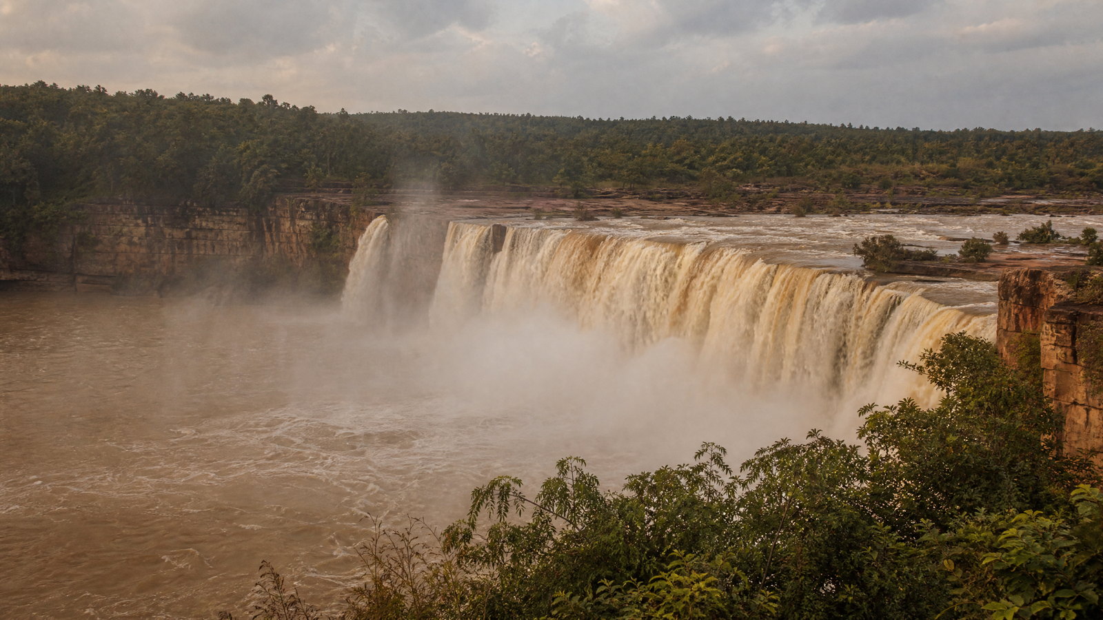
Chitrakote is a broad, horseshoe-shaped waterfall on the Indravati River in Bastar, reached from the Jagdalpur side. The falls are celebrated for their breadth and for the way monsoon flow transforms the river into a powerful curtain of water. This is a landscape attraction first: the scale of the cascade, forested river setting and changing light matter more than any one viewpoint. In low water, the visual character can be markedly different; during and after the rains, the volume is most dramatic but water-edge risk rises sharply. The right way to experience Chitrakote is from safe, designated ground with time for changing conditions rather than close approaches to the river.
Why this place matters
Go to see how the Indravati shapes Bastar’s landscape, especially if your travel dates align with post-rain river volume. Chitrakote is visually immediate, making it a strong contrast to the slower cultural and archaeological experiences elsewhere in the state. It works well as a Jagdalpur-based outing, but its beauty does not make it a risk-free monsoon stop: viewpoints, water level and local access must guide the visit. Dry-season travellers may trade torrent-like drama for simpler movement and more stable conditions. The best choice is to match expectations to season rather than expecting the same scene year-round.
national park, forest and limestone cave landscape · Near Jagdalpur, Bastar district
Kanger Valley National Park
Kanger Valley National Park protects a 200-square-kilometre core forest in Bastar, where moist peninsular sal forest meets the northern reach of teak. The Kanger River runs through a hilly valley whose attractions include forest, streams, Tirathgarh Falls and limestone caves such as Kutumsar and Kailash. The park is ecologically distinctive because its entire designated area is core, not a casual recreational zone. Wildlife and the Bastar hill myna are part of the setting, but the stronger reason to visit is the whole forest-and-geology relationship. Its caves and waterfalls are subject to conservation, weather and safety decisions, so a flexible plan is essential.
Why this place matters
Choose Kanger Valley for a deeper southern forest experience than a roadside waterfall alone can provide. It combines a distinctive sal-and-teak transition, river valley, cave geology and the possibility of wildlife interpretation in one protected landscape. It is best approached from Jagdalpur with enough time to accept gate procedures and any closure, rather than as a tightly scheduled excursion. The dry-season visiting period has historically made November through June the core window; monsoon can be visually rich outside the park but is not a reason to assume internal access. For conservation-minded travellers, Kanger is a place to move slowly and let park rules define the visit.
reservoir and river landscape · Near Dhamtari, Dhamtari district
Gangrel Reservoir
Gangrel, also known as Ravishankar Dam, is a Mahanadi reservoir near Dhamtari in the central part of the state. Its wide water, vegetated edges and islands make it a useful water landscape within reach of the Raipur region, particularly when monsoon replenishes the reservoir and surrounding greenery. The appeal is scenic and seasonal rather than historic: open horizons, reservoir light and a change of pace from temple and forest circuits. Water activities have been promoted here at times, but they are operational details, not the essence of the place. Gangrel is best understood as a managed water body whose appearance and permitted activities shift with water level and weather.
Why this place matters
Visit Gangrel to add river-and-reservoir scale to a central Chhattisgarh route. It is a sensible counterbalance to the enclosed forest of Barnawapara or the carved stone of Bhoramdeo, and can work for travellers with limited time outside Raipur. The strongest visual season may coincide with rain, but that is also when wind, surface conditions and changing water level deserve the most caution. In drier months, the calmer practical conditions may be preferable even if the scene is less lush. Go for an unhurried waterside view, not a promise of a specific activity or access to an island.
pilgrimage town and temple landscape · Dantewada town, Dantewada district
Dantewada and Danteshwari Temple
Dantewada is a southern Chhattisgarh town of hills, streams and deeply rooted sacred geography. The Danteshwari Temple is the district’s defining pilgrimage landmark and is closely connected to the wider cultural imagination of Bastar. District material places it among a broader field of temples, waterfalls and hill sites, including the historic temple landscape at Barsur. The value of Dantewada is therefore not only architectural: it is the experience of a living place of worship within a forested plateau region. Its southern location and local conditions mean that it deserves its own measured planning rather than an impulsive extension from Jagdalpur.
Why this place matters
Go if you want to understand the devotional dimension that underlies much of Bastar’s cultural landscape. Danteshwari Temple gives a meaningful spiritual counterpoint to Jagdalpur’s festival context, Kondagaon’s material arts and the region’s natural scenery. It can be combined thoughtfully with Barsur or other district sites only when road, weather and public guidance support it; the priority should be a respectful temple visit, not distance accumulation. Travellers who value pilgrimage architecture, local ritual and less formulaic regional travel will find Dantewada compelling. It is less suitable for those seeking a quick, frictionless excursion without time for current local orientation.
Season and pace
Choose a date window for the experience, then keep a fallback.
November through February is the widest comfort window: days are generally manageable for temples, towns and wildlife routes, although upland mornings can be cool. March through June brings severe heat in the plains; plan outdoor time early and protect against sun exposure. Mainpat can feel gentler but remains weather-variable. Monsoon usually reshapes the state from late June into October. Waterfalls, forests and reservoirs gain visual force, yet heavy rain, slippery paths, high water and local road disruption are real trade-offs. Kanger’s published visitor period has historically excluded the rains, and sanctuaries have seasonal patterns; opening dates, cave access and water activity depend on current orders. Forecasts and public alerts should override generalisations, particularly near forest, river and waterfall landscapes.
Movement and planning
Distance on a map is not the same as usable travel time.
Moving through the region
Raipur is the practical arrival and resupply hub, but it does not erase the state’s scale. Road travel links many places; private vehicles, vetted local drivers and local transport may each suit different districts. Jagdalpur is the base for Chitrakote, Kanger Valley and Bastar; Ambikapur serves Mainpat. Sirpur, Bhoramdeo, Barnawapara and Gangrel are more realistic central additions than a rapid cross-state loop. Plan daylight arrivals in forested or hilly areas, retain offline navigation and carry water. Do not assume uniform fuel, repair, cash or mobile access outside major towns. Avoid tightly timing caves, safaris, waterfalls or mountain roads. Confirm current transport, gate rules, road repairs and public-safety guidance through the relevant local or official channel before departure.
Building a workable route
Pair one central cluster with either the south or north. For three or four heritage-focused days, base around Raipur and connect Sirpur with Bhoramdeo, Barnawapara or Gangrel according to conditions. For a fuller week, use Jagdalpur for Chitrakote, Kanger Valley and Bastar’s living culture, with Kondagaon or Keshkal as a purposeful stop. A northern alternative links Ambikapur and Mainpat; do not force it into a short Bastar itinerary. Keep protected-area visits flexible: wildlife cannot be scheduled, and entry or guide rules may change. Dress modestly at temples, respect restricted spaces and carry layers for winter mornings, rain protection in the wet season and sturdy footwear. Confirm weather, roads, local permissions and operating hours shortly before travel.
Travel responsibly
The regional context includes its limits.
Forest, river, craft and ritual landscapes in Chhattisgarh are not empty backdrops. In protected areas, use authorised access, keep quiet, never feed wildlife and do not pressure staff for an encounter. At waterfalls, remain on designated safe ground; monsoon flow and wet rock can change risk quickly. In villages, workshops and ceremonies, ask before making images, recording sound or entering workspaces, and accept a refusal. Sacred sites may have footwear, dress, entry or photography rules that change during worship. Reduce single-use waste and carry litter out of rural areas. Prioritise locally made craft with transparent authorship, while recognising skilled labour fairly. Follow weather and public-safety instructions without improvising alternatives; changed conditions are a reason to reroute.
This is an evergreen regional guide. Weather, permits, closures, transport and local rules can change; confirm material conditions through the relevant local or official channel before travel.