East India · State · BR
Bihar
Bihar is an East Indian state where a broad, river-made plain carries some of South Asia’s most consequential sacred and intellectual landscapes. Patna, its capital on the Ganga, is a practical urban base; south and east lie the brick ruins of Nalanda and Vikramshila, while Bodh Gaya, Rajgir, Pawapuri and Vaishali connect Buddhist, Jain, Hindu and Sikh histories that remain living traditions. North Bihar shifts the emphasis toward Mithila’s painted visual language, fertile floodplains and the Himalayan-terai edge of Valmiki Tiger Reserve. This is not a single-circuit destination: a reflective heritage journey, a religious pilgrimage, a craft-focused stay and a wildlife visit involve very different distances, facilities and rhythms. The strongest itineraries pair nearby clusters rather than treating the state as a quick transit between monuments. Cool, drier months usually make long road days and open archaeological sites more comfortable. In the monsoon, river conditions, rain and local disruption can reshape plans, especially across the north; flexible timing and current local confirmation are essential.
Regional notebook
Begin with the shape of the region.
Bihar is best approached as a network of living sacred places, archaeological landscapes and river-plain communities, not a monument checklist. Patna is the main urban gateway; Bodh Gaya, Rajgir, Nalanda and Pawapuri form the most coherent south-central cluster. North Bihar shifts toward Vaishali, Kesariya, Mithila art and wetlands, while Valmiki and Vikramshila are separate extensions. Buddhist, Jain, Sikh, Hindu and Islamic traditions are present in the cultural landscape. This selection is representative, not exhaustive. Strong itineraries pair nearby places and leave time for context. The trade-off is distance: rural heritage, forest and wetland visits require more patience than the principal pilgrimage hubs.
Landscape
Geography changes the journey.
Bihar covers about 94,163 square kilometres in the central Indo-Gangetic plain. The Ganga is the principal east–west drainage corridor, with North Bihar on its left-bank side and South Bihar on its right-bank side. Himalayan-fed northern systems include the Gandak, Bagmati, Kamla-Balan, Kosi and Mahananda; southern basins include the Son and Punpun. Most travel is low-altitude plains travel. Rajgir and Barabar introduce rocky, uneven hill terrain, while Valmiki touches the Himalayan-terai forest edge. The dynamic floodplain creates fertile fields and oxbow wetlands, but it also makes water levels, bridges and monsoon conditions fundamental practical considerations.
Living culture
Arrive as a guest, not an audience.
Bihar’s cultural geography is plural. Bodh Gaya, Nalanda, Rajgir, Vaishali and Vikramshila anchor globally significant Buddhist memory and scholarship; Pawapuri is a major Jain pilgrimage setting; and Patna Sahib is one of Sikhism’s five Takhts. Hindu and Islamic traditions are equally woven into local life. Hindi and Urdu are official languages, while Maithili, Bhojpuri, Magahi, Angika and Bajjika shape regional speech. Mithila painting is a living practice and creative livelihood, not merely decoration. At all sacred places, follow the host community’s norms for dress, silence, footwear, queues and photography. Ask before photographing people, homes, artists or rituals.
Curated regional atlas
Places that reveal different parts of Bihar
This is a selective, geographically varied starting point rather than an exhaustive list. Use it to choose a coherent route, not to compress every place into one trip.
historic city and Sikh pilgrimage precinct · Patna City, Patna district
Patna: Patna Sahib and the Ganga River City
Patna is Bihar’s capital, principal transport hub and a long-settled Ganga city. Its historic core is markedly different from newer administrative districts. Takhat Sri Harimandir Ji Patna Sahib is the key cultural stop: it marks the birthplace of Guru Gobind Singh and is one of Sikhism’s five Takhts. It is an active place of worship rather than architecture alone. The wider city provides river views, museums and an introduction to Bihar’s urban scale. Use Patna as a practical arrival or departure base, but allow time for security, traffic and the devotional rhythm of the old city.
Why this place matters
Choose Patna for Sikh heritage and a grounded view of Bihar’s contemporary civic life. Patna Sahib is a major living pilgrimage institution whose meaning comes from respectful participation or observation, not a rushed monument visit. The city is also the most useful point for recovering from an arrival before travelling to rural heritage clusters. Travellers interested in religious plurality can pair the shrine with the Ganga setting and museums. Visitors seeking quiet rural landscapes should treat Patna as an urban anchor rather than a scenic retreat. Pilgrim and festival movement can make the historic quarter especially busy.
Buddhist pilgrimage city and World Heritage site · Bodh Gaya, Gaya district
Bodh Gaya and the Mahabodhi Temple Complex
Bodh Gaya is Bihar’s foremost Buddhist pilgrimage setting, centred on the Mahabodhi Temple Complex, where tradition locates the Buddha’s enlightenment. The World Heritage property contains the present fifth- or sixth-century brick temple, the Vajrasana, sacred Bodhi Tree and other associated places. Its compact precinct carries both architectural and devotional weight: meditation, circumambulation, chanting and offerings continue alongside conservation. International monasteries give the town a trans-Asian character. This is a place to slow down, observe silence where expected and distinguish the sacred temple precinct from the practical needs of the broader town.
Why this place matters
Go for one of the world’s most consequential living Buddhist sites and an unusually legible early brick monument. It suits pilgrims, students of religion, architecture and conservation, and visitors seeking a contemplative day rather than fast sightseeing. The associated markers make sense as a sequence of sacred memory, not isolated photo points. Bodh Gaya also works as a base for the Gaya area. Major pilgrimage periods can be crowded, while hot months make outdoor waiting tiring. Visitors wanting a quieter experience should arrive early but expect devotional activity throughout the day.
archaeological site and World Heritage site · Nalanda, Nalanda district
Archaeological Site of Nalanda Mahavihara
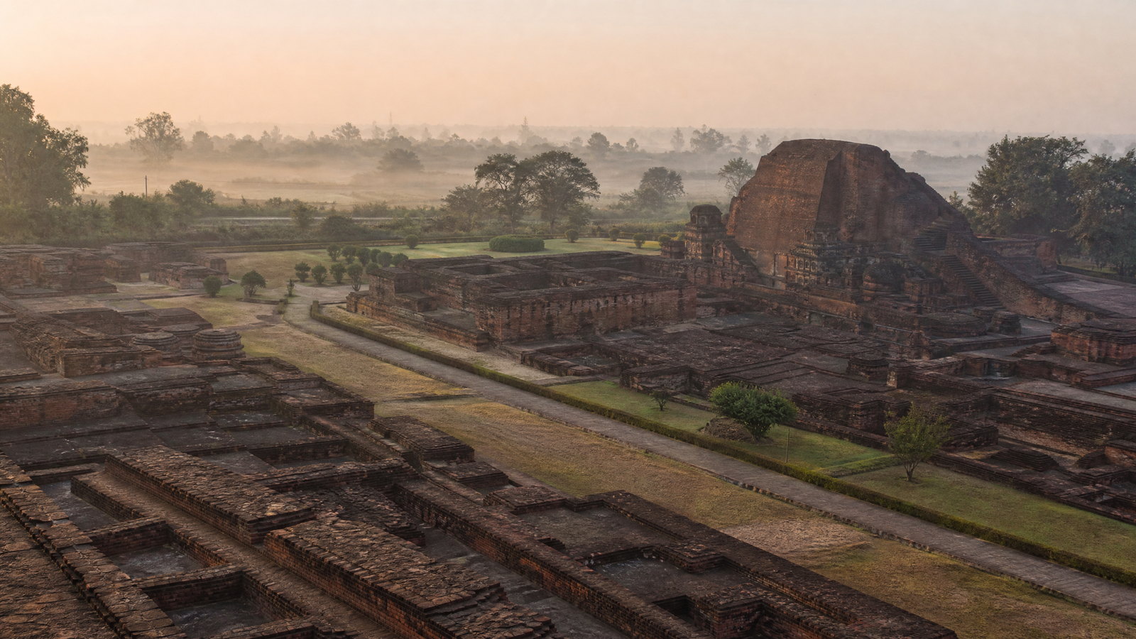
Nalanda Mahavihara preserves excavated remains of a monastic and scholastic institution that developed from the third century BCE and flourished for centuries. The World Heritage site presents brick viharas, temples, shrines, stupas and art remains on a clear north–south plan. It is not a reconstructed university; its strength lies in reading foundations, courtyards, stairs and surviving ornament as evidence of residence, learning and ritual. The agricultural setting helps explain the archaeological landscape’s scale. An unhurried visit, ideally with museum time, clarifies that the excavated remains represent only part of a once much larger institution.
Why this place matters
Nalanda is essential for travellers interested in knowledge systems, Buddhist monasticism, archaeology and the long afterlife of an educational ideal across Asia. It differs from Bodh Gaya: rather than a single active shrine, it offers spatial evidence for institutional life. It pairs naturally with Rajgir and Pawapuri for a coherent two- or three-day cluster. Open brick terrain is exposed to heat and can become slippery after rain, so early hours are wise. Visitors expecting complete standing buildings should adjust expectations; this is an evocative excavation rather than a rebuilt campus.
historic hill town and multi-faith cultural landscape · Rajgir, Nalanda district
Rajgir Hills and Heritage Landscape
Rajgir is a low-hill basin linking ancient Magadha, Buddhist memory, Jain pilgrimage, Hindu sacred geography and contemporary recreation. Features include the Cyclopean Wall, hot springs, Ghora Katora, Gridhakuta Hill and Vishwa Shanti Stupa, but the town-and-hills setting is the meaningful unit. The enclosing hills provide relief from Bihar’s flat plains and make Rajgir a natural companion to Nalanda. They also create constraints: slopes, steps, exposed paths and variable transport access. Rajgir can be busy around popular attractions, yet early starts and a paced itinerary reveal the contour and depth of its older landscape.
Why this place matters
Choose Rajgir when you want heritage interpreted through terrain. Defensive-wall traces, caves, springs and hills make historical movement visible in a way Nalanda’s flat excavation does not. It is also a strong place for understanding religious coexistence across time. A full day prevents the hill setting becoming a series of quick stops. The trade-off is mobility: uneven terrain, heat and crowding may limit comfort. Travellers preferring level, barrier-free attractions should select individual accessible features. Confirm hill transport and current conditions before committing to a demanding route.
Jain pilgrimage site · Pawapuri, Nalanda district
Pawapuri and Jal Mandir
Pawapuri is a major Jain pilgrimage town, known for Jal Mandir, a white temple in a lotus-filled tank. Jain tradition associates the place with Mahavira’s liberation and cremation, and the temple holds a Charan Paduka connected with him. The water-and-walkway composition is visually calm, but the precinct’s importance is devotional rather than scenic alone. Pawapuri pairs naturally with Rajgir and Nalanda, adding a living Jain dimension to a route often dominated by Buddhist heritage. Allow time to arrive respectfully, remove footwear where required and sit quietly rather than treating the temple as a brief photographic stop.
Why this place matters
Go to understand the plural character of Bihar’s heritage routes. Pawapuri offers a focused Jain setting unlike Nalanda’s archaeological remains or Rajgir’s dispersed hills, making it an important counterweight to Buddhist-only itineraries. Its island-like form and lotus water create a calm spatial experience in cooler light. It suits a half-day visit within the Nalanda cluster and travellers interested in pilgrimage, ethics and religious architecture. Observances can increase crowds, and the walkway may feel constrained for some visitors. Recognise that reverence and ritual shape the encounter.
archaeological and multi-faith pilgrimage landscape · Kolhua and Vaishali area, Vaishali district
Vaishali and Kolhua
Vaishali is an important north Bihar pilgrimage and archaeological landscape associated with the Licchavi polity, Mahavira’s birthplace tradition and events in the Buddha’s life. At Kolhua, the polished sandstone Ashokan Pillar and nearby Buddhist remains provide a tangible focus. District authorities also identify a relic stupa and early republican political memory. This is an open, dispersed historical landscape rather than a dense museum precinct. Rural roads, weather and distances between features make it a destination for a planned day, not a casual stop between Patna and the northeast.
Why this place matters
Vaishali joins political memory, Buddhist pilgrimage and Jain tradition in the riverine north. The Ashokan pillar offers an elegant material contrast to Nalanda’s vast brick ruins and Kesariya’s stupa mass. It suits travellers connecting sacred geography with questions of governance, mobility and ancient urban life. Pairing it with Patna or Kesariya makes sense, but it needs time for its rural setting. Facilities can be more limited than at Bodh Gaya or Patna, and monsoon conditions may slow access. Carry water and shade protection, and maintain flexible expectations about pace.
Buddhist archaeological monument · Kesariya, East Champaran district
Kesariya Stupa
Kesariya Stupa rises from East Champaran’s plains as a large tiered Buddhist monument linked by tradition to the Buddha’s final journey and gift of his alms bowl to the Licchavis. The visible structure has multiple polygonal levels and reflects early construction with later expansion. It is a protected archaeological monument, so the experience is looking closely at brick geometry and open landscape rather than entering a functioning temple. Its scale is striking because it stands away from a major city. Kesariya works as a dedicated north Bihar heritage stop, especially with Vaishali, not as a rushed southern-circuit add-on.
Why this place matters
Go for monumental scale and a different expression of Buddhist heritage from Bodh Gaya’s active temple or Nalanda’s excavation. Kesariya shows how a stupa orders a rural horizon and how conservation protects vulnerable brick fabric. It rewards interest in pilgrimage routes, Gupta-period development and archaeology in an agricultural setting. The place has little shade and can be intensely hot, with limited reason to linger at midday in summer. Do not climb for a view. Its value lies in form, history and setting, which require distance and care rather than physical conquest.
Mauryan rock-cut cave complex · Barabar Hills near Makhdumpur, Jehanabad district
Barabar Caves
The Barabar Caves are granite chambers cut into the Barabar Hills in Jehanabad district and are widely recognised as India’s earliest surviving rock-cut caves. Their Mauryan-period interiors are remarkable for precise forms, polished surfaces and acoustic effects; inscriptions and historical associations connect the complex to ancient religious communities. The experience is intimate rather than monumental: a dark hard-stone chamber makes the technical achievement immediate. The hill setting is integral, with uneven approaches, exposed rock and a rural context. Barabar complements Bihar’s brick archaeology by showing a radically different material tradition from the same broad ancient world.
Why this place matters
Choose Barabar for architecture, craft and sensory experience. The caves show that ancient heritage is not only large ruins: polished granite, vault-like profiles and resonant sound preserve extraordinary technical knowledge. It suits visitors willing to walk carefully on hill terrain and look slowly at few features. Pair it with Gaya or south Bihar rather than the northern circuit. Interiors can feel close, dark or echoing. Heat, rain-slick rock and limited accessibility are important trade-offs. Visit in daylight and follow every barrier; the site rewards attention, not speed.
Buddhist archaeological site · Antichak, Kahalgaon area, Bhagalpur district
Ruins of Vikramshila
At Antichak near Kahalgaon, Vikramshila preserves a major Pala-period Buddhist centre of learning established by King Dharmapala. Excavated remains include a substantial central shrine or stupa complex, monastery traces and evidence of a large institutional settlement. Its setting near the Ganga gives it a different character from Nalanda: this is east Bihar, reached through Bhagalpur’s riverine landscape rather than Rajgir’s hills. Vikramshila feels quieter and more remote, so preparation matters. The site rewards visitors who can read foundations and spatial traces; little survives as a complete standing historic building.
Why this place matters
Vikramshila suits travellers moving beyond Bihar’s best-known Buddhist sites to understand the wider Pala-era network of scholarship. Its scale and plan help explain how a monastic university functioned as an organised settlement, while its Ganga-side context suggests routes, patronage and exchange. Pair it with Bhagalpur as a dedicated eastern extension, not a rushed day from Patna. Distance and a limited visitor environment are the trade-offs. Archaeology enthusiasts, students and repeat visitors will gain most; those wanting polished interpretation or indoor displays should set expectations accordingly and allow a full travel day.
craft region and cultural town · Madhubani and surrounding Mithila, Madhubani district
Madhubani and the Mithila Art Region
Madhubani is the main urban reference point for Mithila painting, a living visual tradition rooted in the wider Mithila region. It is known for line drawing, bright colour, dense patterning and subjects from nature, mythology, ritual and social life. Historically created on plastered walls and floors, it later moved onto paper, cloth and canvas; artists use fingers, twigs, brushes and pens. The town and nearby villages are not a single open-air gallery, so meaningful engagement depends on respectful local connections when welcome. This is a cultural landscape where artistic knowledge, household practice and contemporary livelihoods meet.
Why this place matters
Go to encounter living art in regional context, not merely to acquire a souvenir. Madhubani shows how inherited wall-painting traditions became important creative work for many households while artists continue to reshape the practice. It counterbalances Bihar’s ancient monuments by centring contemporary makers. Visitors interested in visual culture, craft ethics and regional language will find more depth than at a quick retail stop. Quality, access and workshop availability vary. Ask before photographing people, homes or art, and seek clear attribution for any work. A respectful, pre-arranged interaction is more meaningful than uninvited observation.
Ramsar wetland and bird habitat · Begusarai district
Kabartal Wetland
Kabartal Wetland, also known as Kanwar Lake, is a freshwater oxbow wetland in Begusarai and Bihar’s first Ramsar site. Its Ramsar area was designated in 2020 and covers 2,620 hectares. Water levels, vegetation and season alter its character; it is not an urban lake with uniform viewpoints. Birdlife and wetland processes are the central reasons to visit, particularly when migratory and resident birds use the habitat. The site also reveals the ecological stakes of Bihar’s riverine plain, where water retention, agriculture, fishing and biodiversity intersect. View it with restraint and patience rather than pursuing close wildlife encounters.
Why this place matters
Choose Kabartal for a nature-focused counterweight to Bihar’s sacred and archaeological sites. The wetland introduces oxbow formation, seasonal water and bird habitat within an intensely inhabited agricultural region. Cooler months are often most comfortable for observation, but wildlife presence and viewing conditions cannot be guaranteed. It suits birders, long-lens photographers, ecology students and travellers who value quiet landscapes. The trade-off is unpredictability: water level, vegetation, bird movement, access and local guidance can change. Accept distant views, minimise noise and avoid putting birds or wetland-edge communities under pressure.
tiger reserve and Himalayan-terai forest · Valmiki Nagar area, West Champaran district
Valmiki Tiger Reserve
Valmiki Tiger Reserve in northwestern Bihar is the state’s only tiger reserve and forms the easternmost limit of India’s Himalayan-terai forests. In the Gangetic Plains biogeographic zone, its landscape combines bhabar and terai tracts and supports forest wildlife, birds, reptiles and amphibians. It lies far from the core Buddhist circuit, which is part of its value: this is Bihar as forest edge and floodplain rather than brick monument country. Visits should follow lawful reserve procedures, habitat respect and realistic wildlife expectations. A forest drive or birdwatching session can be worthwhile even when large mammals remain unseen.
Why this place matters
Go for Bihar’s strongest forest experience and the contrast between terai ecology and cultivated plains. Valmiki offers a way to learn about habitat, birdlife and conservation in a landscape shaped by Himalayan foothill processes. It suits wildlife-minded travellers willing to give the reserve time and accept that sightings cannot be promised. Distance is the key trade-off: it needs a northwestern extension rather than a rushed overnight from Patna. Operations can be seasonal and weather-sensitive. Prioritise quiet observation, authorised guidance where required and a low-impact pace over attempts to maximise animal encounters.
Season and pace
Choose a date window for the experience, then keep a fallback.
October to March is generally Bihar’s most comfortable travel window. Cool, drier conditions suit archaeological walks, hill paths and long road days; winter mist can affect visibility and movement, but can also suit wetland birding. March and April remain workable with early starts, water and heat caution. May and early June can be severely hot on exposed brick and stone. The southwest monsoon, broadly June to September, brings humidity, thunderstorms, waterlogging and variable northern flood disruption. September is transitional. Seasonal labels are planning guidance, not a forecast: check current district weather warnings and travel conditions before outdoor days or long transfers.
Movement and planning
Distance on a map is not the same as usable travel time.
Moving through the region
Patna is the principal air, rail and road gateway; Gaya is useful for Bodh Gaya and the southern circuit. Rail serves major towns, but a last-mile road journey is common. A hired vehicle can simplify multi-stop rural days, especially for Vaishali, Kesariya, Barabar, Madhubani, Kabar Tal and Vikramshila, though it cannot make times predictable. Local autos and buses are useful but can be crowded and less accessible. Site accessibility varies sharply: heritage terrain, hill paths, wetland edges and forest vehicles may be uneven or step-heavy. Travellers using mobility aids should confirm the exact approach, seating, washrooms and assistance through the relevant local or official channel.
Building a workable route
Plan by clusters, not by straight-line distance. Allow distinct days for Bodh Gaya, the Rajgir–Nalanda–Pawapuri group and Patna; extend north for Vaishali, Kesariya, Madhubani or Kabar Tal. Valmiki and Vikramshila deserve dedicated overnight extensions. Carry sun protection, refillable water, stable footwear and clothing suitable for worship spaces. Morning is best for exposed archaeological terrain. Before departure, confirm current opening arrangements, security procedures, photography rules, transport changes, weather alerts, festival effects and site-specific access through the relevant local or official channel. Keep buffer time around every rail, flight or long road connection, particularly in monsoon or major pilgrimage periods.
Travel responsibly
The regional context includes its limits.
Treat sacred sites as active religious spaces, not backdrops. Follow rules on dress, head covering, footwear, silence, queues and photography; never photograph worshippers or private rituals without clear permission. At archaeological sites, do not climb, touch, trace, rub or sit on masonry, inscriptions, cave surfaces or sculpture. Carry out waste and reduce single-use plastic. In wetlands and forests, keep distance from wildlife, do not feed or call animals, use no playback and remain in authorised areas. Respect weather and flood warnings over fixed schedules. In craft settings, seek permission, credit makers and pay fairly for work or guidance when invited.
This is an evergreen regional guide. Weather, permits, closures, transport and local rules can change; confirm material conditions through the relevant local or official channel before travel.