South India · State · AP
Andhra Pradesh
Andhra Pradesh rewards a route built around contrasts rather than a single circuit. The Bay of Bengal edge moves from Visakhapatnam’s city-and-sea setting to mangrove estuaries and the bird-rich Pulicat lagoon; inland, river plains meet Buddhist archaeology and pilgrimage towns. The Eastern Ghats rise into the forested, coffee-growing Araku landscape, while the drier southwest holds granite, fort walls, and the Penna gorge at Gandikota. Sacred travel is central rather than incidental: Tirumala and Srisailam are living places of worship with their own rhythms, while Amaravati and Nagarjunakonda illuminate the lower Krishna valley’s Buddhist past. Telugu is the everyday anchor, but the state’s cultural geography also includes tribal communities of the northern hills and craft lineages in towns such as Pedana and Kuchipudi.
Regional notebook
Begin with the shape of the region.
Andhra Pradesh is an east-coast state whose visitor geography is best understood as several linked regions: the northern Eastern Ghats and Visakhapatnam coast, the Krishna–Godavari delta and central river plains, the Nallamala forests, and the drier Rayalaseema interior. Amaravati is the state capital, with its modern capital-region project layered beside an older Buddhist and Shaiva landscape on the Krishna.
Landscape
Geography changes the journey.
The Bay of Bengal coastline creates humid maritime conditions and a broad deltaic world of rivers, backwaters, sandy spits, and mangroves. The Krishna and Godavari systems have supported settlement, farming, and major Buddhist sites. North of Visakhapatnam, the Eastern Ghats rise into the Araku–Ananthagiri uplands, where much of the district landscape sits roughly 600–900 metres above sea level and higher peaks surround it. West and south, the Nallamala’s dry deciduous forest, ridges, gorges, and Krishna valley contrast with Rayalaseema’s hotter, rockier country.
Living culture
Arrive as a guest, not an audience.
Telugu provides the main linguistic and literary frame, while faith, craft, food, and performance vary by locality. Kuchipudi emerged as a dance-drama tradition in Krishna district; the region also sustains Andhra Natyam, folk forms, puppetry, and ritual music. Northern hill communities maintain distinct social and artistic traditions; Dhimsa is associated with the Araku cultural landscape. Pedana’s block-printed Kalamkari and other artisan practices are working livelihoods, not merely souvenirs. Temple towns are living religious environments, so dress, photography, entry, queues, and festival access must respect local rules.
Curated regional atlas
Places that reveal different parts of Andhra Pradesh
This is a selective, geographically varied starting point rather than an exhaustive list. Use it to choose a coherent route, not to compress every place into one trip.
capital city and Buddhist heritage landscape · Palnadu and Guntur capital-region area, Krishna River
Amaravati
Amaravati is both Andhra Pradesh’s capital and a layered riverbank landscape rather than a finished capital-city spectacle. The Krishna-side settlement is associated with the Amareswara temple and with a major Buddhist past: the area was a seat of Buddhism before the Satavahanas, and its stupa and monastery tradition reaches back to the Mauryan period in official accounts. The archaeological remains and museum context make the ancient site a thoughtful counterpoint to the changing capital region around it. This is a place for visitors interested in how sacred geography, early Buddhist art, farming country, and contemporary state-building coexist in a compact but evolving setting.
Why this place matters
Choose Amaravati for a measured introduction to the state’s historical depth and its present administrative identity. It works especially well for travellers who prefer archaeology and riverside context to a conventional urban checklist, and it links naturally with Vijayawada, Guntur, and Nagarjunakonda. The value lies in reading the stupa site, museum objects, temple setting, and capital-region landscape together. It is less satisfying for someone seeking a dense, fully built metropolitan experience: development, access patterns, and visitor amenities can change. Give the site time, avoid treating it as a quick roadside stop, and let current on-site guidance determine what is viewable.
coastal city and heritage corridor · Visakhapatnam district, Bay of Bengal coast
Visakhapatnam
Visakhapatnam places a working east-coast city between the Bay of Bengal and the Eastern Ghats. Its appeal is not only the urban shoreline: the district’s recognised heritage list includes the hilltop Buddhist sites of Thotlakonda and Bavikonda, the Simhachalam temple, and Borra Caves as a geo-heritage destination farther inland. This gives the city a useful role as a gateway, where a waterfront stay can be paired with early Buddhist history, temple architecture, museums, or a climb toward the hills. The coastal atmosphere is humid, and sea conditions can change quickly, but the city remains the region’s most practical northern base.
Why this place matters
Go to Visakhapatnam when you want a genuinely urban pause without leaving Andhra Pradesh’s larger landscape story behind. It is the logical start or finish for Araku and a sensible base for a short coast-and-heritage route. The mix of beach roads, port-city energy, hill viewpoints, and nearby Buddhist sites is more varied than a beach-only visit. Trade-offs are traffic, humidity, and a coastline exposed to seasonal weather systems. Use the city for flexible logistics, but reserve enough time to visit one heritage hill in cooler hours and to experience the shore with appropriate caution rather than assuming all water activities are available.
Eastern Ghats hill landscape and limestone cave system · Alluri Sitarama Raju district
Araku Valley and Borra Caves
Araku Valley lies high in the Eastern Ghats, roughly 115 kilometres from Visakhapatnam, with much of the valley between about 600 and 900 metres above sea level. Forested ghat roads, coffee-growing Ananthagiri slopes, horticulture, and tribal cultural life distinguish it from the coast. Nearby Borra Caves are a limestone system in the Ananthagiri hills, known for stalactites and stalagmites formed by water over long periods. The valley is inhabited by Indigenous communities whose traditions, including Dhimsa in the regional cultural landscape, deserve respectful, consent-led engagement. Araku is best approached as a living hill region, not a theme set.
Why this place matters
This is Andhra Pradesh’s strongest counterpoint to the hot plains: cooler air, dramatic relief, coffee landscapes, cave geology, and a slower hill rhythm. It suits travellers who can stay overnight and value landscape interpretation over rapid sightseeing. The cave visit adds a distinct geological layer, while the valley can support thoughtful learning about local agriculture and cultural traditions. The trade-off is that hill weather, fog, rain, and winding roads make same-day ambitions fragile. Some activities marketed locally are seasonal or operator-dependent.
mangrove and estuarine wildlife sanctuary · Kakinada–Konaseema coast, Godavari delta
Coringa Wildlife Sanctuary
Coringa is an estuarine sanctuary in the Godavari delta landscape near Kakinada, where deltaic branches of the Godavari and the Coringa and Gaderu river systems intersect marshland, backwaters, mangroves, and dry deciduous forest. The sanctuary covers about 235.7 square kilometres in the district account and includes Andhra Pradesh’s largest surviving mangrove patch. Its significance is ecological rather than theatrical: mangrove roots, tides, mudflats, birds, fish nurseries, and the protective work of coastal vegetation are the story. It provides a valuable change of scale after city and monument travel, and a reason to understand the coast as a lived river–sea system.
Why this place matters
Visit Coringa for a quiet encounter with the Godavari delta, especially if you are interested in wetlands, mangrove ecology, or coastal resilience. It pairs well with Kakinada or a broader east-coast route and encourages a slower, observation-led day rather than an activity-packed excursion. The sanctuary is not a reliable place to demand close wildlife encounters; tides, weather, seasonal access, and conservation management determine what can be seen. That uncertainty is part of its value. Choose authorised routes, keep a respectful distance from birds and animals, and let knowledgeable local interpretation guide the visit instead of treating mangroves as a backdrop.
pilgrimage town and dry-forest landscape · Nandyal district, Nagarjunasagar–Srisailam landscape
Srisailam and the Nallamala
Srisailam is a major living pilgrimage centre in the Nallamala hills, set within the wider geography of the Nagarjunasagar–Srisailam Tiger Reserve. The reserve is an immense dry deciduous forest system of plateau, ridges, gorges, deep valleys, bamboo, and grass around the Krishna, with a documented mosaic of wildlife and human-use edges. Srisailam therefore needs two kinds of attention: the devotional rhythm around the Mallikarjuna–Bhramaramba shrine and the ecological limits of a protected forest. Community-based nature initiatives at nearby Nallamala villages show that conservation and local livelihoods are part of the visitor story. Do not confuse a pilgrimage road with unrestricted forest access.
Why this place matters
Srisailam is compelling for travellers who want spiritual practice, Deccan landscape, and conservation context in one journey. The temple is meaningful as an active place of worship, while the surrounding Nallamala makes the approach visually and ecologically distinct from lowland temple towns. It is best for visitors willing to adjust to queues, festival crowds, road timing, and forest regulations. Wildlife sightings are never assured, and responsible visitors do not pursue them beyond permitted areas. Stay long enough to separate temple time from any nature visit, arrive with modest clothing, and accept a closure or altered route as an appropriate conservation decision.
living pilgrimage city and hill temple complex · Tirupati district, Seshachalam hills
Tirumala–Tirupati
Tirumala–Tirupati is one of South India’s most important living pilgrimage environments, centred on the hill shrine of Sri Venkateswara at Tirumala and the service city below. The main temple complex occupies a substantial sacred precinct shaped over generations, with gateways, mandapas, ritual passages, and visible Vijayanagara-era patronage. Its importance is devotional before it is architectural, and the visitor experience is organised around worship schedules, queue systems, security, and crowd management. The surrounding Seshachalam hill setting adds elevation and forest context, but temple access should not be treated as a casual mountain outing. The best visit is patient, prepared, and respectful of religious priority.
Why this place matters
Go if you wish to understand how a major contemporary pilgrimage functions at scale, or if the temple’s sacred and architectural history is a central interest. Tirupati offers stronger transport links and services than many interior places, making it a useful southern anchor. However, it is not a quiet heritage stop: queues can be long, access procedures may change, and festival periods can transform the pace. A well-planned visit rewards those who leave ample time, observe dress and conduct requirements, and distinguish reliable historical context from beliefs held within the tradition.
Vijayanagara temple and sculpture complex · Sri Sathya Sai district
Lepakshi
Lepakshi’s Sri Veerabhadra temple and monolithic Nandi form one of Andhra Pradesh’s most concentrated statements of Vijayanagara sculpture, painting, and granite craftsmanship. The complex sits on the low granite Kurmasaila hill, with three shrine zones, pillared halls, enclosure walls, a Naga-sivalinga, and murals that narrate epic and Puranic themes. Major construction belongs to the mature Vijayanagara period, especially the sixteenth century, though its architectural story has earlier and later phases. The property is on India’s UNESCO Tentative List, a status that recognises its proposed significance but is not the same as World Heritage inscription. It remains a place of worship as well as study.
Why this place matters
Lepakshi is essential for travellers who want to look slowly at South Indian stonework and painted temple interiors. The interplay of sculpted pillars, narrative ceilings, monolithic forms, and a functioning sacred setting gives it more depth than a single landmark photograph. It fits a Bengaluru-facing or Rayalaseema route, but deserves at least a half-day rather than a hurried stop. The key trade-off is fragility: murals and carvings are not durable props. Avoid touching surfaces, respect worship activity, and heed any photography or access limitations.
historic fort and Penna River gorge · YSR Kadapa district
Gandikota
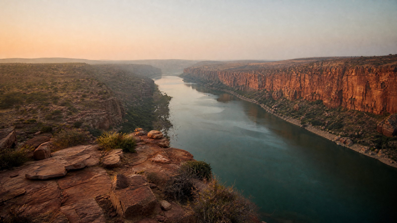
Gandikota rises above the Penna River where the river has cut a dramatic gorge through the Erramala hills. Its name joins the Telugu words for gorge and fort, and the fortified landscape carries a long political history involving Kakatiya, Vijayanagara, Qutb Shahi, Mughal, Mysore, and British periods. Within the enclosure, temple architecture, a mosque, defensive walls, granary, and other structures reveal changing patronage rather than a single-era monument. The river viewpoint gives the site its visual force, but the geological setting and layered built fabric make it more than a canyon stop. Sun and stone dominate the experience.
Why this place matters
Choose Gandikota for an unusually direct encounter between Deccan fort history and river-cut geology. It is especially rewarding for travellers who enjoy ruins, long views, and the texture of a dry interior landscape. The Madhavaraya temple, Jama Masjid, and Penna gorge together make a strong half- or full-day visit, particularly in lower-temperature months. The trade-off is exposure: shade is limited, uneven surfaces are common, and viewpoint conditions change with weather and water. Do not climb beyond safe, designated areas or sacrifice caution for a photograph.
brackish lagoon and bird sanctuary landscape · Tirupati district, Andhra Pradesh–Tamil Nadu coast
Pulicat Lake
Pulicat Lake is a large brackish lagoon shared by Andhra Pradesh and Tamil Nadu, and is identified by the Tirupati district as India’s second-largest brackish-water lagoon. Its bird sanctuary landscape supports flamingos, painted storks, egrets, pelicans, herons, pintails, stilts, shovelers, and terns, though species presence changes with water, season, and migration. The lagoon’s coast is also shaped by the Sriharikota barrier and by weather systems that bring northeast-monsoon rain. This is a wetland to observe with patience: light, wind, salinity, bird movement, fishing livelihoods, and access routes all affect the experience. It is not simply a checklist of species.
Why this place matters
Pulicat is one of the state’s clearest opportunities to see a coastal wetland as an interconnected bird, water, weather, and community landscape. It suits birders, photographers who work at a distance, and travellers seeking an ecological complement to Tirupati’s pilgrimage focus. Winter can be especially compelling, but wildlife is never guaranteed and water access is not a fixed entitlement. Sensitive habitats and nearby restricted infrastructure make rule-following essential. Use viewing areas and authorised local arrangements, keep voices low, avoid flash and playback, and do not pursue birds or attempt access across restricted shorelines or islands.
dance heritage village · Krishna district
Kuchipudi
Kuchipudi is the Krishna district village associated with the classical dance-drama form of the same name. The tradition developed as a religiously rooted performance art connected with temple practice, spiritual narratives, travelling performers, and later formal repertoires. District documentation describes a performance structure that can move from invocation and short dance to pure dance and expressive dance, often oriented around Krishna and Vaishnava themes. The village’s value is place-memory: it helps ground a globally taught classical form in a specific Telugu cultural landscape. It should not be treated as a guarantee of an on-demand performance or as a museum frozen outside ordinary village life.
Why this place matters
Visit Kuchipudi if you want to connect an art form to its geographical and social origins, especially as part of a Krishna district route with Amaravati, Vijayawada, Pedana, or Machilipatnam. The experience is most meaningful when framed as cultural learning rather than entertainment consumption. Seek locally appropriate information about any public programme, leave room for ordinary village rhythms, and approach dance institutions or artists with courtesy. It is a more specialised stop than a broad scenic destination, but that is precisely its strength: it reveals how language, devotional literature, training, and performance are embedded in place.
textile craft town and working artisan landscape · Pedana and Machilipatnam area, Krishna district
Pedana Kalamkari Landscape
Pedana, near Machilipatnam on the coastal plain, is the centre of the Machilipatnam or Pedana style of Kalamkari. This is one of India’s two principal Kalamkari traditions and uses carved wooden blocks and vegetable dyes on cloth, unlike the hand-painted Srikalahasti style. Production is geographically rooted in Pedana and nearby localities, where scouring, mordant preparation, block printing, drying, washing, and finishing reflect a sequence of skilled labour rather than a single decorative gesture. The style received geographical-indication recognition in 2013. A visit can make visible the relationship among design, natural-dye knowledge, water, workshop organisation, and coastal-town history.
Why this place matters
Pedana gives craft-minded travellers a way to encounter a living textile tradition at its source. It works well with Kuchipudi or Machilipatnam and is more rewarding when approached as an artisan economy, not merely a shopping stop. The block-printed method, vegetable-dye process, and local concentration of workshops provide real interpretive depth. Yet workshops are workplaces, and production schedules, dye stages, and visitor welcome vary. Ask before entering or photographing, avoid pressing for demonstrations, and buy only when the maker or seller can explain provenance and process.
archaeological island museum and Buddhist heritage landscape · Palnadu district, Nagarjuna Sagar reservoir
Nagarjunakonda
Nagarjunakonda, or Nagarjuna’s hill, preserves the memory of ancient Vijayapuri in a Krishna valley later transformed by the Nagarjuna Sagar reservoir. Intensive mid-twentieth-century archaeology salvaged remains from more than 130 sites as the valley faced submergence; selected structures were reconstructed on the island and eastern bank, and excavated material is displayed in the Archaeological Survey of India museum. The site records a long sequence from prehistoric settlement to Buddhist and Brahmanical activity, with the Ikshvaku-period city becoming a major centre of art, architecture, inscriptions, and Buddhist study. Its island setting makes the preservation story as important as the galleries.
Why this place matters
Nagarjunakonda is for travellers who want archaeology with an ethical and technical preservation dimension. The museum’s limestone reliefs, inscriptions, models, and material from Buddhist and Brahmanical contexts make it a powerful companion to Amaravati, while the reservoir setting explains why the site is arranged as it is. The visit asks for flexibility rather than speed: lake access, launch operation, weather, water levels, and museum arrangements can all determine feasibility. Plan it as a dedicated excursion, not an inflexible connection. Once there, read the reconstructed remains as evidence of both ancient Vijayapuri and a modern rescue effort under difficult conditions.
Season and pace
Choose a date window for the experience, then keep a fallback.
For most itineraries, November through February reduces heat stress and suits outdoor heritage, coastal walks, and the Pulicat bird season. Araku is cooler than the plains but can be misty or wet, so winter mornings and monsoon edges need flexible plans. March to June can bring intense heat, especially in inland and Rayalaseema districts; early starts, shade, hydration, and a reduced outdoor schedule are prudent. The southwest monsoon broadly affects June to September, while the coast also faces northeast-monsoon rain and Bay of Bengal cyclone risk later in the year. Rain can transform scenery but also disrupt road, boat, forest, and cave plans.
Movement and planning
Distance on a map is not the same as usable travel time.
Moving through the region
Visakhapatnam, Vijayawada, Tirupati, and the Amaravati–Guntur area are useful transport anchors, with rail and road corridors connecting the coast and central plains. Gannavaram serves the Vijayawada region; Visakhapatnam and Tirupati provide other practical air gateways. Public transport can work well between major centres, but the strongest experience of Gandikota, Araku-side villages, Coringa, Pulicat, and dispersed heritage is usually easier with a locally arranged road transfer. Hill roads bring curves, fog, and slower progress; do not plan mountain travel after dark merely to meet a tight schedule. Nagarjunakonda depends on lake-side access and boat operations, while forest visits and temple approaches can have separate timing systems.
Building a workable route
Choose a spine rather than attempt every signature place. A north-and-coast route can pair Visakhapatnam, Araku, and Coringa; a central route can join Amaravati, Vijayawada, Kuchipudi or Pedana, and Nagarjunakonda; a south-and-interior route can connect Tirumala, Pulicat, Lepakshi, Gandikota, and Srisailam. Combining all three usually needs at least ten unhurried days. Keep temple visits separate from archaeology or city sightseeing on festival days, and do not make a pilgrimage queue the final event before a train or flight. Carry sun protection, refillable water, modest clothing, sturdy shoes, and a light rain layer in wet periods.
Travel responsibly
The regional context includes its limits.
Andhra Pradesh’s natural and cultural places are vulnerable to daily choices. In Coringa and Pulicat, keep distance from birds, avoid loud playback, do not leave plastic or food waste, and use only authorised access or water transport when available. In the Nallamala, stay on permitted visitor areas, never seek wildlife sightings off-route, and accept closures for fire, weather, or conservation reasons. At caves, temples, murals, carvings, and fort walls, do not touch, climb, mark, or fly equipment where it may disturb heritage, worship, or wildlife. Coastal communities and hill villages are homes and workplaces: request consent for portraits and buy crafts with clear provenance and fair, direct payment. Heat, heavy rain, rough water, and cyclone warnings are safety boundaries, not inconveniences.
This is an evergreen regional guide. Weather, permits, closures, transport and local rules can change; confirm material conditions through the relevant local or official channel before travel.